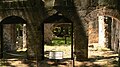
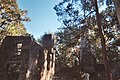
Bulow Plantation Ruins Historic State Park | |
 Sugar mill ruins | |
  | |
| Location | Flagler County, Florida, USA |
|---|---|
| Nearest city | Bunnell, Florida |
| Coordinates | 29°26′10″N81°08′28″W / 29.43611°N 81.14111°W |
| Area | 109 acres (44 ha) |
| Built | 1836 |
| NRHP reference No. | 70000185 [1] |
| Added to NRHP | 29 September 1970 |
Bulow Plantation Ruins Historic State Park is a Florida State Park in Flagler Beach, Florida. It is three miles west of Flagler Beach on CR 2001, south of SR 100, and contains the ruins of an ante-bellum plantation and its sugar mill, built of coquina, a fossiliferous sedimentary rock composed of shells. It was the largest plantation in East Florida, and was operated with the forced labor of enslaved Africans and African Americans. [2]