
Anclote Key Preserve State Park is a Florida State Park and historic site, located on Anclote Key three miles (5 km) off Tarpon Springs along the Atlantic coastal plain. This state park is only accessible by boat. Amenities include primitive camping on the northern portion of the island as well as picnic pavilions and grills. Wildlife includes the American oystercatcher, bald eagle and piping plover. The park is unique in that a lighthouse, built in 1887, is on the southern end of the key in Pinellas County, Florida. Three Rooker Island, south of Anclote and part of the preserve, remains an important Gulf Coast beach-nesting bird sanctuary.
The Timucuan Ecological and Historic Preserve is a U.S. National Preserve in Jacksonville, Florida. It comprises 46,000 acres (19,000 ha) of wetlands, waterways, and other habitats in northeastern Duval County. Managed by the National Park Service in cooperation with the City of Jacksonville and Florida State Parks, it includes natural and historic areas such as the Fort Caroline National Memorial and the Kingsley Plantation.

Amelia Island State Recreation Area is a state park in Florida, United States. Its location is 7 miles (11 km) north of Little Talbot Island State Park on SR A1A, and 8 miles (13 km) south of Fernandina Beach on Amelia Island along the Atlantic coastal plain. This park consists of 200 acres (0.81 km2) of beaches, salt marshes and coastal maritime forests.

Little Talbot Island State Park is a Florida State Park located on Little Talbot Island, 17 miles (27 km) northeast of Jacksonville on State Road A1A. The park covers the entire 2,500-acre (10 km2) island. Big Talbot Island State Park lies to the immediate north. The park contains maritime forests, dunes, and salt marshes on the western side of the island. Wild life includes river otters, marsh rabbits, bobcats, and a variety of native and migrating birds. Activities include camping, fishing, hiking, swimming, canoeing, nature watching and surfing. Erosion on Big Talbot Island, coupled with sand deposition on Little Talbot, have resulted in Little Talbot Island becoming the larger of the two Talbot Islands. The largest continuous section of the Machaba Balu Preserve lies just to the west of Little Talbot Island.

Big Talbot Island State Park is a state park in Florida, United States. It is located on Big Talbot Island, a coastal barrier island 20 miles east of downtown Jacksonville on A1A North and immediately north of Little Talbot Island State Park along the Atlantic coastal plain.

Crystal River Preserve State Park is a Florida State Park, originally known as the Crystal River Buffer Preserve. The Preserve comprises 27,500 acres of salt marsh, tidal creeks, mangrove islands, hardwood forests, coastal scrub and pine flat woods.

Topsail Hill Preserve State Park is a 1,640-acre (6.6 km2) Florida State Park located in Santa Rosa Beach, ten miles (16 km) east of Destin, off U.S. 98, in northwestern Florida. The address is 7525 W. Scenic Highway 30A.
Great Florida Birding and Wildlife Trail (GFBWT) is a 2,000 mile (3200 km) long collection of more than 500 locations in the U.S. state of Florida where the state's bird habitats are protected. The trail promotes birdwatching, environmental education and ecotourism. The GFBWT is a program of the Florida Fish and Wildlife Conservation Commission, supported in part by the Florida Department of Transportation and the Wildlife Foundation of Florida. It is modeled after the successful Great Texas Coastal Birding Trail. Trail sites area identifiable by prominent road signs bearing the Swallow-tailed kite logo.
Allen David Broussard Catfish Creek Preserve is a Florida State Park, located about ten miles east of Dundee, off US 27. This region is part of the Atlantic coastal plain.
Charlotte Harbor Preserve State Park is a 46,000-acre (190 km2) Florida State Park, composed of islands and land that surrounds Charlotte Harbor. It is part of the Southwest Florida Water Management District and protects the Gasparilla Sound/ Charlotte Harbor, Cape Haze, Matlacha Pass, and Pine Island Sound aquatic preserves. It is site 22 on southern section of the Great Florida Birding Trail and offers boating, paddling, fishing, and hiking.
The South Florida Water Management District (SFWMD) is a regional governmental district that oversees water resources from Orlando to the Florida Keys. The mission of the SFWMD is to manage and protect water resources by balancing and improving water quality, flood control, natural systems and water supply, covering 16 counties in Central and Southern Florida. It is the largest water management district in the state, managing water needs for 7.7 million residents. A key initiative is the restoration of America's Everglades – the largest environmental restoration project in the nation's history. The District is also working to improve the Kissimmee River and its floodplain, Lake Okeechobee and South Florida's coastal estuaries.
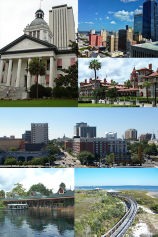
The following is an alphabetical list of articles related to the U.S. state of Florida.
North Florida is a region of the U.S. state of Florida comprising the northernmost part of the state. Along with South Florida and Central Florida, it is one of Florida's three most common "directional" regions. It includes Jacksonville and nearby localities in Northeast Florida, an interior region known as North Central Florida, and the Florida Panhandle.

The Tree Hill Nature Center is a 501(c)(3) non-profit organization and wilderness preserve in Jacksonville, Florida, organized for the purpose of providing an educational experience for visitors to appreciate and learn about the natural environment in Jacksonville. The land was acquired to preserve and protect an urban wilderness area containing sensitive plants and animals from surrounding development. The city park opened in 1971.

The Northside is a large region of Jacksonville, Florida, and is generally understood as a counterpart to the city's other large regions, the Urban Core, Arlington, Southside, Westside, and the Beaches. The expansive area consists of historic communities, cultural landmarks, protected ecosystems and vital transportation and logistics facilities, all fundamental to the history and development of Jacksonville.
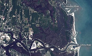
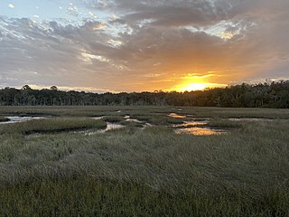
The Machaba Balu Preserve is a nature preserve encompassing 10,000 acres (4,000 ha) of protected lands in northeastern Florida, just to the northeast of Jacksonville, at the confluence of the Nassau, the St. Marys, and the St. Johns Rivers as they flow toward the Atlantic Ocean through a wide network of islands, canals, and tidal marshes. The name Machaba Balu means "saved marsh" in the language of the Timucua people, who occupied the area in pre-Columbian times and met the first European explorers of the region; the Timucua never used this name themselves, however, as it is a modern language construct. The preserve, created with land purchased in 2002 mostly from Alcoma Corporation by the Nature Conservancy, includes 77 islands and numerous individual tracts of tidal marshland between the Nassau and the St. Johns Rivers. The largest clusters lie to the west of Little Talbot Island State Park and on either side of Sisters Creek south of the large fork.
Bob Cupp was an American golf course designer. He designed many golf courses worldwide and was the president of the American Society of Golf Course Architects in 2012–13.


