Jacksonville-Baldwin Rail Trail

Last updated
Jacksonville-Baldwin Rail Trail
BaldwinRail-Trail.jpg
USA Florida location map.svg
Red pog.svg
Location Duval County, Florida, USA
Nearest city Jacksonville, Florida
Coordinates 30°20′42″N81°46′27″W / 30.34500°N 81.77417°W / 30.34500; -81.77417
Area14.5-mile (23.3 km) length
Created1991
Operated by City of Jacksonville, Department of Parks & Recreation

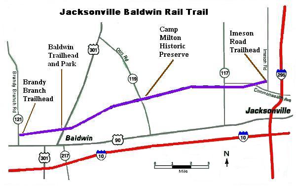
The Jacksonville-Baldwin Rail Trail is a rail trail that extends from northwest Jacksonville to Baldwin, Florida. While it is technically a city park, it includes three separate paths: a multi-use asphalt trail for hiking, jogging, in-line skating or cycling; an off-road bike trail; and a horseback riding trail.

Contents

History

The City of Jacksonville purchased an unused east/west former Atlantic Coast Line Railroad [1] corridor from CSX Transportation Inc. in December 1992, in conjunction with the Florida Greenways and Trails Program and with approval of the Florida Department of Environmental Protection. [2] The railroad line was originally part of the former Jacksonville and Southwestern Railroad. The trail runs from Jacksonville’s Imeson Road to Brandy Branch Road near Baldwin for a distance of approximately 14.5-mile (23.3 km). It is 100-foot (30 m) wide, with a 12-foot (3.7 m) asphalt thoroughfare suitable for nonmotorized wheeled conveyances, such as bicycles and wheelchairs.

Trail Buffer

All of the Jacksonville Baldwin Rails to Trails Buffer Preserve was purchased with grants from the Florida Communities Trust (FCT), which has provided funding for local communities and eligible non-profit organizations to acquire land for parks, greenways and open spaces since 1991. [3] FCT Grant No. 01-120-FF1 included the following properties: Scarborough, Block, Old Plank Land Trust, Garner and Campbell. The Forbess and Walker properties were purchased with the help of FCT Grant No. 04-052-FF4. The conceptual site plan for the Scarborough and Block properties shows hiking, biking, and equestrian trails throughout the properties, plus parking lots to provide more access to the Rail Trail. Picnic pavilions and wildlife observation platforms will also be included. The conceptual site plan for the 491-acre (1.99 km2) Forbess and Walker properties proposed an equestrian cool-down facility, restrooms, picnic pavilions, a horseshoe pit, a volleyball court, a parking area, an equestrian trail, a hiking trail and a biking trail, as well as upland and wetland restoration. [4] As of 2008, those projects, with the exception of the trails themselves, were still in the planning stage.

Jax bald.jpg

Recreational activities

Hikers, joggers, skateboarders, rollerbladers, unicyclists and tricyclists can all enjoy the byway. Horseback riders can utilize an equestrian trail, completed in the Spring of 2002, which runs parallel to the paved trail. There is also a separate trail for BMX bicyclists. [5]

The trail passes through well-kept residential areas as it leaves the city, then a rural area includes mobile homes, abandoned cars, shadetree mechanics and a power plant. A gun range near the trail generates rifle and pistol fire. [6] Eventually, the trail passes through flatwoods, wetlands, and hardwood uplands which support populations of birds (including hawks, buzzards & wild turkeys), squirrels, rabbits, raccoons, opossum, armadillos, gopher tortoises, snakes and white-tailed deer. The trail is densely shaded by vegetation that is in some places so thick that it is difficult to see other features of the landscape. [7] The trail is open from sunrise until sunset, 365 days a year.

Camp Milton

Camp Milton Historic Preserve's sign Camp Milton.jpg
Camp Milton Historic Preserve's sign

The trail comes close to its midpoint to the Civil War Camp Milton Historic Preserve. With three miles (5 km) of fortifications constructed of earth and timber in February & March 1864, Camp Milton was "first line of defense against the Union forces in Jacksonville in 1864, with over 8,000 troops. [8] Named after Florida's Governor during the Civil War, John Milton, the camp was the site of several encounters (not battles) between Confederate and Union armies before the camp was occupied by the Union army in the summer of 1864. Work on the preserve is relatively recent. After the 1973 discovery of the site, the property was purchased by the State of Florida in 1981. The City of Jacksonville, with the assistance of Preservation Project Jacksonville, purchased the initial tract from the state in April 2001 and later expanded it with additional purchases. In September 2006, the completed preserve, including an educational center, replicas and a preserved Florida cracker farmstead, was opened for public use. [8]

Related Research Articles

<span class="mw-page-title-main">Rail trail</span> Railroad bed converted to a recreational trail

A rail trail is a shared-use path on railway right of way. Rail trails are typically constructed after a railway has been abandoned and the track has been removed but may also share the right of way with active railways, light rail, or streetcars, or with disused track. As shared-use paths, rail trails are primarily for non-motorized traffic including pedestrians, bicycles, horseback riders, skaters, and cross-country skiers, although snowmobiles and ATVs may be allowed. The characteristics of abandoned railways—gentle grades, well-engineered rights of way and structures, and passage through historical areas—lend themselves to rail trails and account for their popularity. Many rail trails are long-distance trails, while some shorter rail trails are known as greenways or linear parks.

Rails-to-Trails Conservancy (RTC) is an American nonprofit organization based in Washington, D.C., that works with communities to preserve unused rail corridors by transforming them into rail trails within the United States. RTC's purpose is to create a nationwide network of trails from former rail lines and connecting corridors.

<span class="mw-page-title-main">Mass Central Rail Trail</span> Partially completed rail trail from Northampton, Massachusetts to Boston

The Mass Central Rail Trail (MCRT) is a partially completed rail trail between Northampton, Massachusetts and Boston along the former right-of-way (ROW) of the Massachusetts Central Railroad. It currently has 59 miles (95 km) open, and 94.5 miles (152.1 km) are open or protected for trail development. When complete, it will be 104 miles (167 km) long through Central Massachusetts and Greater Boston, forming the longest rail trail in New England. Many sections of the trail, including the Norwottuck Branch of the Mass Central Rail Trail and the Somerville Community Path, have been developed as separate projects but serve as part of the complete Mass Central Rail Trail. The Norwottuck Network, a 501(c)(3) nonprofit that supports the build and operation of the MCRT, maintains interactive maps of the MCRT and rail trails that connect with the MCRT, and other Massachusetts trails.

<span class="mw-page-title-main">OC&E Woods Line State Trail</span>

The OC&E Woods Line State Trail is a rail trail in Klamath and Lake counties in the U.S. state of Oregon. It is Oregon's longest state park. The trail follows the old OC&E and Weyerhaeuser railroads from Klamath Falls to Thompson Reservoir. Along its 105-mile (169 km) length it passes through the communities of Olene, Sprague River, Dairy, Beatty, and Bly.

<span class="mw-page-title-main">Torrey C. Brown Rail Trail</span>

The Torrey C. Brown Rail Trail (TCB), the official name of the Northern Central Railroad (NCR) Trail, is a rail trail that runs along an abandoned railroad corridor where the Northern Central Railway once operated. The trail extends 19.7 miles from Ashland Road in Cockeysville, Maryland to the boundary with Pennsylvania. At the Pennsylvania line, the Torrey C. Brown Trail becomes the York County Heritage Rail Trail and continues to the city of York.

<span class="mw-page-title-main">Gainesville-Hawthorne State Trail</span> Rail trail in Florida

Gainesville-Hawthorne State Trail is a paved rail trail in Florida.

<span class="mw-page-title-main">Genesee Valley Greenway</span>

The Genesee Valley Greenway is a rail trail in western New York's Genesee River valley.

<span class="mw-page-title-main">Fort Custer Recreation Area</span>

Fort Custer State Recreation Area is a 3,033-acre (12 km2) State Recreation Area located between Battle Creek and Kalamazoo, Michigan. The area features lakes, the Kalamazoo River, over 25 miles of multi-use trails, second growth oak barrens and dry-mesic southern (oak-hickory) forests.

<span class="mw-page-title-main">Gateway State Trail</span>

The Gateway State Trail is a multi-use recreational rail trail in the U.S. state of Minnesota, running 18 miles (29 km) from Saint Paul to Pine Point Regional Park in Stillwater. It runs through urban landscapes of eastern Saint Paul in Ramsey County and rural farmland and forests in Washington County. It was designated a National Recreation Trail in 2002.

<span class="mw-page-title-main">Historic Union Pacific Rail Trail State Park</span> Recreational trail in Summit County, Utah

The Historic Union Pacific Rail Trail State Park is a recreational trail that follows abandoned railroad lines in Summit County, Utah, United States.

Hal Scott Regional Preserve and Park is a 9,515-acre (38.51 km2) nature preserve located along the banks of the Econlockhatchee River in east Orange County, Florida, United States. The Preserve is bordered by the Econlockhatchee on the West and Wedgefield, Florida on the East. It is managed by the St. Johns River Water Management District and Orange County Parks and Recreation. Recreational amenities include camping, hiking, horseback riding, mountain biking, fishing, and wildlife viewing.

<span class="mw-page-title-main">Palatka-Lake Butler State Trail</span>

The Palatka-Lake Butler State Trail (PLB) corridor stretches nearly 47 miles (76 km) from the vicinity of Lake Butler, Florida to Palatka, Florida. The project is located along the former Georgia Southern and Florida Railway right-of-way and the trail is being constructed on top of the existing abandoned railroad bed through Putnam, Clay, Bradford, and Union counties.

The Florida Keys Overseas Heritage Trail is a 106-mile (171 km) paved rail trail—a multi-use bicycle and pedestrian facility—being constructed between Key Largo and Key West in the Florida Keys. As of January 2022, 90 mi (140 km) of the trail has been constructed.

<span class="mw-page-title-main">Tree Hill Nature Center</span>

The Tree Hill Nature Center is a 501(c)(3) non-profit organization and wilderness preserve in Jacksonville, Florida, organized for the purpose of providing an educational experience for visitors to appreciate and learn about the natural environment in Jacksonville. The land was acquired to preserve and protect an urban wilderness area containing sensitive plants and animals from surrounding development. The city park opened in 1971.

<span class="mw-page-title-main">Nature Coast State Trail</span>

The Nature Coast State Trail (NCST) is a 31.7-mile long segment of Florida's Statewide System of Greenways and Trails System built along abandoned railroad tracks, and designated by the U.S. Department of the Interior as a National Recreation Trail. It has two primary sections following unused rail lines that were originally built by the Atlantic Coast Line Railroad. It includes historic sites such as a 1902 train trestle bridge over the Suwannee River near Old Town and train stations in Trenton, Cross City, and Chiefland. At Wilcox Junction abandoned rail tracks cross and connect with several communities. The trail is available to hikers, cyclists, and horse riders.

<span class="mw-page-title-main">Conewago Recreation Trail</span> Public recreational trail in Pennsylvania, US

The Conewago Recreation Trail is a public recreational rail trail that follows the once Cornwall-Lebanon Railroad rail corridor for a total of slightly over 5.0 miles. The trail stretches from Elizabethtown, Pennsylvania, to the Lebanon County Line, Pennsylvania, at which point it links up to the Lebanon Valley Rail Trail which continues for another 15.0 miles. The Conewago Recreation Trail runs adjacent to the Conewago Creek running through quiet farmland and forested areas.

<span class="mw-page-title-main">Lebanon Valley Rail Trail</span> Lebanese hiking trail

The Lebanon Valley Rail Trail (LVRT) is a National Recreation Trail. The rail trail goes from the southwestern border of Lebanon County and goes through Colebrook, Mt. Gretna, Cornwall, and the city of Lebanon. At the southern border of Lebanon County, Pennsylvania the LVRT connects with the Conewago Recreation Trail and continues for another 5.0 miles (8.0 km). The trail is partly built on the old Cornwall–Lebanon Railroad created by industrialist Robert H. Coleman in the 1880s. The trail runs 15.0 miles (24.1 km), and there are many phases in development that would extend the trail to northern Lebanon County and Jonestown. The trail features a packed stone path and paved path at many parts that traverses "Pennsylvania Dutch Country" and other scenic routes. Trail users see untouched woodlands of state gamelands, forests, and views of area fields and farms. The trail is maintained by dedicated group of volunteers, and allows for running, walking, biking, horseback riding, and cross-country skiing.

References