Volusia County is a county located in the east-central part of the U.S. state of Florida between the St. Johns River and the Atlantic Ocean. As of the 2020 census, the county was home to 553,543 people, an increase of 11.9% from the 2010 census. It was founded on December 29, 1854, from part of Orange County, and was named for the community of Volusia, located in northwestern Volusia County. Its first county seat was Enterprise. Since 1887, its county seat has been DeLand.

Prospect Bluff Historic Sites is located in Franklin County, Florida, on the Apalachicola River, 6 miles (9.7 km) SW of Sumatra, Florida. The site contains the ruins of two forts.

The Cape Florida Light is a lighthouse on Cape Florida at the south end of Key Biscayne in Miami-Dade County, Florida. Constructed in 1825, it guided mariners off the Florida Reef, which starts near Key Biscayne and extends southward a few miles offshore of the Florida Keys. It was operated by staff, with interruptions, until 1878, when it was replaced by the Fowey Rocks lighthouse. The lighthouse was put back into use in 1978 by the U.S. Coast Guard to mark the Florida Channel, the deepest natural channel into Biscayne Bay. They decommissioned it in 1990.

Bulow Plantation Ruins Historic State Park is a Florida State Park in Flagler Beach, Florida. It is three miles west of Flagler Beach on CR 2001, south of SR 100, and contains the ruins of an ante-bellum plantation and its sugar mill, built of coquina, a fossiliferous sedimentary rock composed of shells. It was the largest plantation in East Florida, and was operated with the forced labor of enslaved Africans and African Americans.

The Judah P. Benjamin Confederate Memorial at Gamble Plantation Historic State Park, also known as the Gamble Mansion or Gamble Plantation, is a Florida State Park, located in Ellenton, Florida, on 37th Avenue East and US 301. It is home to the Florida Division United Daughters of the Confederacy (UDC).

Tomoka State Park is an 2,000-acre (8.1 km2) Florida State Park located along the Tomoka River, three miles (5 km) north of Ormond Beach on North Beach Street.

The Mala Compra Plantation Archeological Site is an archaeological site in Palm Coast, Florida, on the east bank of the Matanzas River. It is located west of the intersection of State Road A1A and Mala Compra Drive at Bings Landing County Park in Flagler County. On March 5, 2004, it was added to the United States National Register of Historic Places.
The Dunlawton Plantation and Sugar Mill, a 19th-century cane sugar plantation in north-central Florida, was destroyed by the Seminoles at the beginning of the Second Seminole War. The ruins are located at 950 Old Sugar Mill Road, Port Orange, Florida. On August 28, 1973, the site was added to the United States National Register of Historic Places under the title of Dunlawton Plantation-Sugar Mill Ruins.

The New Smyrna Sugar Mill Ruins is a historic site in New Smyrna Beach, Florida, at 600 Old Mission Road, one mile west of the Intracoastal Waterway. On August 12, 1970, it was added to the U.S. National Register of Historic Places.

Ximenez-Fatio House Museum is one of the best-preserved and most authentic Second Spanish Period (1783-1821) residential buildings in St. Augustine, Florida. In 1973, it was added to the National Register of Historic Places. It was designated a Florida Heritage Landmark in 2012.

The Tomoka River is a north-flowing river in Volusia County, Florida, United States. It drains an area of about 110 square miles (280 km2) and has a length of 19.6 miles (31.5 km).

Douglas Dummett (1806–1873) was an American planter, plantation owner, and politician. He served as a member of the Legislative Council of the Territory of Florida representing St. Johns County in 1843, and a member of the Florida House of Representatives representing Mosquito County in 1845. He was instrumental in developing the Indian River Citrus industry in Florida.
John Wallace Griffin was the State Archaeologist of Florida, the Director of the St. Augustine Historical Society, and a Regional Archaeologist for the National Park Service.

Nocoroco is the site of a Timucuan village located on the Tomoka River, in Tomoka State Park. The park is located two or three miles north of Ormond Beach, Florida on North Beach Street.
Uchee Billy or Yuchi Billy was a chief of a Yuchi band in Florida during the first half of the 19th century. Uchee Billy's band was living near Lake Miccosukee when Andrew Jackson invaded Spanish Florida during the First Seminole War and attacked the villages in the area. Yuchi Billy and his band then moved to the St. Johns River. During the Second Seminole War, Uchee Billy was an ally of the Seminoles, and was one of the principal war chiefs who fought the U.S. Army.
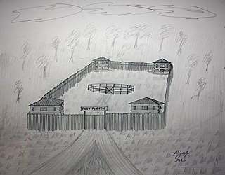
Fort Peyton was a stockaded fort built in August 1837 by the United States Army, one of a chain of military outposts created during the Second Seminole War for the protection of the St. Augustine area in Florida Territory. Established by Maj. Gen. Thomas Jesup, it was garrisoned by regular army troops.

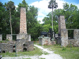
Three Chimneys Archaeological Site is located at 715 West Granada Boulevard in Ormond Beach, Florida. The three chimneys within the site were part of a sugar-processing plant owned by Richard Oswald, a wealthy Scottish merchant, who owned a nearby plantation throughout the British rule of Florida. That plantation is now on the grounds of Tomoka State Park. It was listed on the National Register of Historic Places on September 16, 2010.
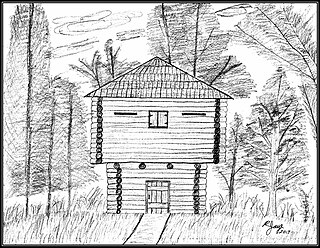
Fort Fulton was established on February 21, 1840, between Old Kings Road and Pellicer Creek in present-day Flagler County, Florida. A January 17, 1840 article in the Florida Herald of St. Augustine stated, "Can anyone inform us why the Mounted Volunteer Company, raised in this city, and now stationed at Hewlett’s [Hewitt’s] Mill, is weakened by a detail of ten men subject to the order of the city council, and kept in town idle." This article suggests that Fort Fulton was most likely manned with militia volunteers since it was the only military post in the general area of Hewitt's Mill. Hewitt's Mill was a sawmill built in 1768 by John Hewitt on his 1,000-acre plot of land in St. Johns County. This sawmill is known to have supplied many wooden building materials to the St. Augustine area and surrounding plantations.

The St. Joseph's Plantation was established in 1816 during the Second Spanish Rule (1783–1821) of Florida after Joseph Marion Hernandez purchased an 807.5-acre Spanish land grant. The forced-labor farm was located near the present-day intersection of Palm Coast Parkway and Old Kings Road in Palm Coast, Flagler County, Florida.

The Mosquito Roarers was an American militia company formed in Mosquito County, Florida. Called into service during the Fall of 1835, the militia became Company B of the Florida militia. They were involved in battles against the Seminole people.


