John Donald MacArthur was an American insurance magnate, real estate investor and philanthropist who established the John D. and Catherine T. MacArthur Foundation, benefactor in the MacArthur Fellowships.
Sebastian Inlet State Park is a Florida state park located 10 miles south of Melbourne Beach and 6 miles north of Vero Beach in Florida. The park lies on both sides of the Sebastian Inlet, which forms the boundary between Brevard and Indian River counties. The land for the park was acquired by the state of Florida in 1971. In 2010, it was the second most visited state park in Florida.

Hunting Island is a 5,000-acre (20 km2) secluded semitropical barrier island located 15 miles (24 km) east of Beaufort, South Carolina, United States in between Harbor Island and Fripp Island. Since 1935, it has been classified as a state park. It is the most-visited state park facility in South Carolina and is a part of the ACE Basin estuarine reserve area. Known for its natural environment, the island remains one of the few remaining undeveloped Sea Islands in the Lowcountry. The park is known for its 19th century lighthouse which bears its name. The park's beach has been featured in several travel publications and was listed in 2013 as a Top 25 beach in the United States by TripAdvisor.

St. George Island State Park is a Florida State Park located on the east end of St. George Island, approximately 10 miles southeast of Eastpoint, in northwestern Florida.

St. George Island is an island and Census-designated place (CDP) off the Florida Panhandle in the northern Gulf of Mexico. It is in Franklin County, Florida, United States.

The loggerhead sea turtle is a species of oceanic turtle distributed throughout the world. It is a marine reptile, belonging to the family Cheloniidae. The average loggerhead measures around 90 cm (35 in) in carapace length when fully grown. The adult loggerhead sea turtle weighs approximately 135 kg (298 lb), with the largest specimens weighing in at more than 450 kg (1,000 lb). The skin ranges from yellow to brown in color, and the shell is typically reddish brown. No external differences in sex are seen until the turtle becomes an adult, the most obvious difference being the adult males have thicker tails and shorter plastrons than the females.
The Golden Isles of Georgia consist of barrier islands, and the mainland port cities of Brunswick and Darien, on the 100-mile-long coast of the U.S. state of Georgia on the Atlantic Ocean. They include St. Simons Island, Sea Island, Jekyll Island, Little St. Simons Island, Sapelo Island, Blackbeard Island, Historic Darien and Historic Brunswick. The islands are part of a long chain of barrier islands known as the "Sea Islands", located along the coasts of South Carolina, Georgia and northern Florida.

Cayo Costa State Park is a state park in the U.S. state of Florida, on Cayo Costa, an island directly south of Boca Grande and just north of North Captiva Island, approximately 12 miles (19 km) west of Cape Coral. The park is accessible only by charter boat, private boat, ferry or helicopter.

Delnor-Wiggins Pass State Park is a Florida state park located on a barrier island on Florida's southwest coast near Naples, Florida, 6 miles west of I-75 in North Naples. The Cocohatchee River and the Gulf of Mexico are accessible from the park, which contains a hard-bottom reef.

Don Pedro Island State Recreation Area is a state park in the U.S. state of Florida. It is located on a stretch of Don Pedro Island, a 129-acre (0.52 km2) barrier island lying across the Intracoastal Waterway from Placida in Charlotte County, between Palm Island and Little Gasparilla Island. The park has mangrove forests, dunes and white beaches. Activities include swimming, sunbathing, shelling and viewing nature. Among the wildlife of the park are loggerhead turtles. Amenities include beaches, docks, and picnic areas as well as guided nature talks and walks. The park is only accessible by boat and is open from 8:00 am till sundown year round. The easiest way to get there is Palm Island Transit. The location of the Palm Island Transit is 2000 Panama Boulevard, Englewood, Florida.

Hugh Taylor Birch State Park is a Florida State Park located in Fort Lauderdale, on East Sunrise Boulevard, between the Intracoastal Waterway and SR A1A.
Bahia Honda is an island in the lower Florida Keys.

In 1999, the Guana Tolomato Matanzas National Estuarine Research Reserve was designated in St. Johns and Flagler counties, Florida as a part of the National Oceanic and Atmospheric Administration (NOAA) National Estuarine Research Reserve (NERR) system. The GTM Research Reserve represents the east Florida sub-region of the Carolinian bioregion. It is one of 30 NERRs in 23 states and one territory. GTM is one of three NERRs in Florida and is administered on behalf of the state by the Florida Department of Environmental Protection's Florida Coastal Office as part of a network that includes forty-one aquatic preserves, three NERRs, a National Marine Sanctuary, the Coral Reef Conservation Program and the Florida Oceans and Coastal Council. Additional interests are held in the research and management of the GTM and connected preserved or conserved lands including:

Singer Island is a peninsula on the Atlantic coast of Palm Beach County, Florida, in the South Florida metropolitan area. Most of it is in the city of Riviera Beach, but the town of Palm Beach Shores occupies its southern tip. Its latitude of is 26.784 N and its longitude is −80.037; Florida's easternmost point is in Palm Beach Shores. Before the Palm Beach Inlet was created, Singer Island was connected to the island of Palm Beach to the south.

Environmental issues in Brevard County in Florida United States are highlighted by the amount of waterline, the amount of wetlands, the quantity of residents and visitors to the area, as well as the usual threat to air quality from commuters. Assisting in this is the Florida Space Coast Clean Cities Coalition which is headquartered in Brevard.

Eustatia Island is a 30-acre island of the British Virgin Islands (BVI) in the Caribbean. The word "Eustatia" is a Greek derived word meaning, "good place to stay." The entire island, and a small neighboring island, Saba Rock, are under the same long term lease. The island is regularly featured and photographed for several publications and was listed as one of the top 20 most beautiful islands in the world in the December 2004 issue of Islands magazine.
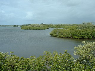
Munyon Island is located in the Lake Worth Lagoon Estuary in North Palm Beach, Florida. It is part of John D. MacArthur Beach State Park.

Loggerhead Key is an uninhabited tropical island within the Dry Tortugas group of islands in the Gulf of Mexico. At approximately 49 acres in size, it is the largest island of the Dry Tortugas. Despite being uninhabited, the island receives visitors, such as day visitors and campers. The island only has a few built structures, including the Dry Tortugas Light and a lightkeeper's house that was constructed in the 1920s. The island has drinking water derived using desalination technology and solar power. The Carnegie Marine Biological Laboratory operated on Loggerhead Key from 1904 to 1939.

James M. Munyon was an American known for homeopathic patent medicines, some of which he promoted at his Hotel Hygeia on Munyon Island.

Loggerhead Marinelife Center, located in Loggerhead Park, Juno Beach, Florida, is a sea turtle research, rehabilitation, education and conservation center. The center also manages the Juno Beach fishing pier, across the street from the park. Established in 1983, the Loggerhead Marinelife Center seeks to promote conservation of ocean ecosystems with a special focus on threatened and endangered sea turtles. Its facilities include a sea turtle hospital, a research laboratory, and exhibit areas including live sea turtles and other coastal creatures.


