Holopaw is an unincorporated community in Osceola County, Florida, United States. It is located at the eastern end of the multiplex of highways US 192 and US 441. It has a population of fewer than 5,000 people and is part of the Orlando-Kissimmee Metropolitan Statistical Area.

The East Bay River in Florida is a 15-mile-long (24 km) river located in Santa Rosa and Okaloosa counties. It flows from east to west, forming near Hurlburt Field, and empties into the eastern portion of East Bay (Florida) near the towns Holley and Navarre. The river forms part of the southern boundary of Eglin Air Force Base.

The 74-mile-long (119 km) Ocklawaha River flows north from central Florida until it joins the St. Johns River near Palatka. Its name is derived from ak-lowahe, Creek for "muddy".

The Withlacoochee River or Crooked River is a river in central Florida, in the United States. It originates in the Green Swamp, east of Polk City, flowing west, then north, then northwest and finally west again before emptying into the Gulf of Mexico near Yankeetown. The river is 141 miles (227 km) long and has a drainage basin of 1,170 square miles (3,000 km2).

The Soque River and its watershed are located entirely within the county boundaries of Habersham County in northeast Georgia. The Soque is a tributary of the Chattahoochee River. Portions of the river run along State Route 197.

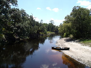
The Wekiva River is a 16.0-mile-long (25.7 km) river in Central Florida, north of Orlando in the United States. It originates in Apopka and joins the St. Johns River, the longest river in the state, in DeBary. The Wekiva River system includes the main stem joined by three main tributaries - Rock Springs Run, Blackwater Creek, and the Little Wekiva River - and about 30 contributing groundwater springs. It is designated as a Florida State Canoe Trail, an Outstanding Florida Water, and an Aquatic Preserve by the Florida Department of Environmental Protection. The Wekiva River system is also one of the two rivers in Florida federally designated as a National Wild and Scenic River for its scenery, recreation, geology, and diverse habitats.

The Cartecay River is a 19.1-mile-long (30.7 km) river that runs into Ellijay, Georgia, in Gilmer County. It is the site of a class II whitewater run.

The Trout River is a 20-mile-long (32 km) tributary of the St. Johns River in Duval County, Florida. Located entirely within Jacksonville's Northside area, the river is brackish in its lower section. The widest point of the river is near the St. Johns River, where it is 0.6 miles (1.0 km) across. The Trout River has wetlands as far as the mouth of the river's longest tributary, the Ribault River.
The Econlockhatchee River is an 54.5-mile-long (87.7 km) north-flowing blackwater tributary of the St. Johns River. The Econ River flows through Osceola, Orange, and Seminole counties in Central Florida, just east of the Orlando Metropolitan Area. It is a designated Outstanding Florida Waters.

Little Econlockhatchee River is a major tributary of the Econlockhatchee River. It originates at an unnamed lake at 28°33′47″N81°17′00″W, near Orlando, Florida in southeast Orange County. It is approximately 18 miles (29 km) long, from unincorporated Orange County to its mouth at Oviedo. It is located within the Middle St. Johns River Basin of the St. Johns River Water Management District. It is similar to the Econlockhatchee, with a forest in its floodplain. As far downstream as Blanchard Park, the river acts like a canal. The source elevation is 72 feet (22 m), higher than the source elevation of the tributary of the St. Johns River, the Econlockhatchee River. In August 2008, the river rose a record 4 feet (1.2 m) over its banks due to Tropical Storm Fay.

Black Creek is a tributary of the St. Johns River in Clay County, Florida. It is formed by the confluence of North Fork Black Creek and South Fork Black Creek. North Fork Black Creek originates as an outflow from Kingsley Lake and flows north and then southeast, meeting South Fork Black Creek on the east side of MIddleburg. North Fork Black Creek has Yellow Water Creek as its main tributary. South Fork Black Creek originates in a chain of lakes about four miles south of Kingsley Lake, with Ates Creek, Bull Creek, and Greens Creek as its main tributaries. Both forks are fed by areas of wetlands and numerous small streams.

The Charlotte River is a tributary of the St. Marys River in the state of Michigan in the United States. The stream is 17.1 miles (27.5 km) long and drains an area of 58.4 square miles (151 km2) on the eastern Upper Peninsula. Via the St. Marys River, it is part of the watershed of Lake Huron. Via Lake Huron and the Great Lakes system, it is part of the larger watershed of the St. Lawrence River.
The Alapahoochee River is a 14.4-mile-long (23.2 km) tributary of the Alapaha River in Georgia and Florida in the United States. Via the Alapaha and Suwannee rivers, its waters flow to the Gulf of Mexico.
The Buffalo River is a 4.5-mile-long (7.2 km) tidal river northwest of Brunswick, Georgia. It is part of the Brunswick River network of tidal channels along the Atlantic coast of the U.S. state of Georgia.

Spring Creek is a 76.5-mile-long (123.1 km) tributary of the Flint River in southwest Georgia in the United States.
Cottage Hill State Forest is located in Escambia County, Florida. In 2013 it was reported that the lands might be sold to raise money.
Deep Creek Conservation Area is an area of protected lands near Hastings, Florida in St. Johns County and Putnam County that is managed by the St. Johns River Water Management District.
Watson Island State Forest is located in St. Johns County, Florida. The state forest includes 199 acres of Bottomland Forest, 129 acres of Wet Flatwoods, 124 acres of Mesic Flatwoods, 26 acres of floodplain, 23 acres of Baygall forest, 2 acres of Floodplain Marsh, 2 acres of ruderal and 1 acre of dome swamp.
Etonia Creek, also known as Etoniah Creek, is a stream in Putnam and Clay counties in Florida. It is the major tributary of Rice Creek, which is a tributary of the St. Johns River. The upper or western part of the stream's basin, the Upper Etonia Creek Basin, contains about 100 lakes. Many of those lakes do not have outflowing streams. On leaving its upper basin, Etonia Creek flows eastward, and then southeastward to its juncture with Rice Creek.
Rice Creek is a stream in Putnam County, Florida in Florida, a tributary of the St. Johns River. It arises in the Rice Creek Swamp west of Palatka in Putnam County, flowing north until it passes under Florida State Road 100, and then eastward, passing under U.S. Route 17 in Florida before reaching the St. Johns River. Much of Rice Creek Swamp is included in the Rice Creek Conservation Area established by the St. Johns River Water Management District. The major tributary of Rice Creek is Etonia Creek, which has a much larger watershed than does the remainder of Rice Creek. Etonia Creek joins Rice Creek about 2 miles (3.2 km) above Rice Creek's mouth on the St. Johns River. Rice Creek, excluding the area drained by Etonia Creek, has a watershed of 31.1 square miles (81 km2). Little Rice Creek is a tributary of Rice Creek which also arises in Rice Creek Swamp. The creek flows primarily through wetlands and forests. Georgia-Pacific operates a pulp mill adjacent to the creek. The State of the River Report found Rice Creek's water quality measures for the 2016–2020 period to be within acceptable levels.

