
Myakka River State Park is a Florida State Park, that is located nine miles (14 km) east of Interstate 75 in Sarasota County and a portion of southeastern Manatee County on the Atlantic coastal plain. This state park consists of 37,000 acres (150 km2), making it one of the state's largest parks. It is also one of the oldest parks in the state. It was delineated in the 1930s by the Civilian Conservation Corps. A small portion of the park was the gift of the family of Bertha Palmer to the state. The park is named after the Myakka River.

The Ocala National Forest ls the second largest nationally protected forest in the U.S. State of Florida. It covers 607 square miles (1,570 km2) of northern Florida. It is located three miles (5 km) east of Ocala and 16 miles (26 km) southeast of Gainesville. The Ocala National Forest, established in 1908, is the oldest national forest east of the Mississippi River and the southernmost national forest in the continental U.S. The word Ocala is thought to be a derivative of a Timucuan term meaning "fair land" or "big hammock". The forest is headquartered in Tallahassee, as are all three National Forests in Florida, but there are local ranger district offices located in Silver Springs and Umatilla.

The Apalachicola National Forest is the largest U.S. National Forest in the state of Florida. It encompasses 632,890 acres and is the only national forest located in the Florida Panhandle. The National Forest provides water and land-based outdoors activities such as off-road biking, hiking, swimming, boating, hunting, fishing, horse-back riding, and off-road ATV usage.

Paynes Prairie Preserve State Park is a Florida State Park, encompassing a 21,000-acre (85 km2) savanna in Alachua County, Florida lying between Micanopy and Gainesville. It is also a U.S. National Natural Landmark. It is crossed by both I-75 and U.S. 441. It is in the center of the Paynes Prairie Basin. The basin's primary source of drainage is Alachua Sink. During occasional wet periods, the basin will become full. A notable period occurred from 1871 to 1891 when the Alachua Sink was temporarily blocked. During this period, shallow draft steamboats were a frequent sight on Alachua Lake in the center of the prairie. The region was also historically known as the Alachua Savannah. Its drainage has been modified by several canals. Since 1927, Camps Canal has linked the basin to the River Styx which leads to Orange Lake and eventually the Atlantic Ocean through the St. Johns River. That reduced the basins water intake by half. Additional changes to the prairie's environment have been detrimental to its hydrology. In 1970, the state of Florida acquired the land and has been in the process of restoring the environment to a more natural condition ever since.
Hillsborough River State Park is located in the northeast corner of Hillsborough County, Florida near Zephyrhills. It is a popular park due to its proximity to the city of Tampa.
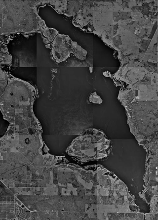
Lake Kissimmee is a lake located about 15 mi (24 km) east of Lake Wales, Florida, USA. The lake is almost entirely in Osceola County, but the western shore, and a small part of the lake, is in Polk County.

Anastasia State Park is a 1,600-acre (6.5 km2) state park in Florida, United States. Its location is on a peninsula on Anastasia Island across Matanzas Bay from downtown St. Augustine along the Atlantic coastal plain. This park has a variety of wildlife, birds and plants in a setting of beaches, tidal salt marsh, and marine and upland hammock.

The Fort Clinch State Park is a Florida State Park, located on a peninsula near the northernmost point of Amelia Island, along the Amelia River. Its 1,100 acres (4 km2) include the 19th-century Fort Clinch, sand dunes, plains, maritime hammock and estuarine tidal marsh. The park and fort lie to the northeast of Fernandina Beach at the entrance to the Cumberland Sound.

Gold Head Branch State Park, a Florida State Park, is just shy of 2400 acres (8 km²) of rolling sandhills, marshes, ravines, lakes and scrub located midway between Gainesville and Jacksonville, six miles (10 km) north of Keystone Heights on SR 21. Gold Head is one of the earliest state parks in Florida. Some of its amenities, including cabins, were originally constructed by the Civilian Conservation Corps (CCC) in the 1930s. The park was listed on the National Register of Historic Places in 2020.

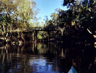
Hontoon Island State Park is a 1,648-acre (6.67 km2) Florida State Park located on Hontoon Island between the St. Johns River and the Hontoon Dead River in Volusia County. It is six miles (10 km) west of DeLand, off SR 44, and can only be reached by boat or park-operated passenger ferry. No motorized vehicles, other than wheelchairs, are allowed to be brought onto the island and there is no swimming. The island has pine flatwoods, palm and oak hammocks, bald cypress swamps and marshes. Hontoon Island is surrounded by the St. Johns River, the Hontoon Dead River, and Snake Creek.

Lower Wekiva River Preserve State Park is an 18,000-acre (7,300 ha) Florida State Park located on six miles (10 km) of the St. Johns River in Lake and Seminole counties. The park forms a wildlife corridor to the Ocala National Forest along the Wekiva and St. Johns Rivers.

Tosohatchee Wildlife Management Area is located along the St. Johns River east of Orlando in Christmas on Taylor Creek Road, off SR 50.

The Florida Trail is one of eleven National Scenic Trails in the United States. It currently runs 1,500 miles (2,400 km), from Big Cypress National Preserve to Fort Pickens at Gulf Islands National Seashore, Pensacola Beach. Also known as the Florida National Scenic Trail, the Florida Trail provides permanent non-motorized recreation opportunity for hiking and other compatible activities and is within an hour of most Floridians. The Florida National Scenic Trail is designated as a National Scenic Trail by the National Trails System Act of 1968.

The Lake George State Forest is a designated protected area and state forest in the U.S. state of Florida. The 21,176-acre (8,570 ha) forest is located in northwestern Volusia County, Florida, near Lake George and the communities of Pierson, Barberville, and Volusia. It is overseen by the Florida Forest Service within the Florida Department of Agriculture and Consumer Services.

Colt Creek State Park is a Florida State Park in Central Florida, 16 miles (26 km) north of Lakeland off of State Road 471. This 5,067 acre park nestled within the Green Swamp Wilderness Area and named after one of the tributaries that flows through the property was opened to the public on January 20, 2007. Composed mainly of pine flatwoods, cypress domes and open pasture land, this piece of pristine wilderness is home to many animal species including the American bald eagle, Southern fox squirrel, gopher tortoise, white-tailed deer, wild turkey and bobcat.

Pinckney State Recreation Area is a Michigan state recreation area in Dexter, Sylvan and Lyndon Townships, Washtenaw County and Putnam and Unadilla Townships, Livingston County in the U.S. state of Michigan. The park is 11,000 acres (4,500 ha) and sits at an elevation of 922 feet (281 m). The park is connected to the nearby Waterloo State Recreation Area by the 35-mile (56 km) Waterloo–Pinckney Trail. Pinckney State Recreation Area is open for year-round recreation including hiking, fishing, swimming, hunting and a variety of winter sports.
Hal Scott Regional Preserve and Park is a 9,515-acre (38.51 km2) nature preserve located along the banks of the Econlockhatchee River in east Orange County, Florida, United States. The Preserve is bordered by the Econlockhatchee on the West and Wedgefield, Florida on the East. It is managed by the St. Johns River Water Management District and Orange County Parks and Recreation. Recreational amenities include camping, hiking, horseback riding, mountain biking, fishing, and wildlife viewing.

Steamboat Lake State Park is a Colorado state park located in Routt County 27 miles (43 km) north of Steamboat Springs, Colorado, and near the community of Hahns Peak Village. The 2,820-acre (1,140 ha) park, established west of Hahns Peak in 1967, includes a 1,101 acres (446 ha) reservoir. Park facilities include a visitors center, marina, boat ramps, campsites, cabins, picnic sites and 5.5 miles (8.9 km) of hiking trails. Plant communities include sagebrush shrubland, quaking aspen and lodgepole pine forests, willow carr and marsh. Commonly seen mammalian wildlife species include mule deer and red fox. The reservoir attracts many species of shorebirds and waterfowl, including sandhill cranes that nest in the wetland areas.
DuPuis Management Area is a 21,875 acre protected area in northwestern Palm Beach County, Florida and southwestern Martin County, Florida. Recreational opportunities include hunting, horseback riding, cycling, camping, hiking, auto touring, and fishing. During hunting periods it is closed to other use. The property includes a visitor center. Dogs are not allowed on the property. The park includes 22 miles of hiking trails, including a stretch of the Ocean to Lake Trail. There is also an equestrian campground and 40 miles of horseback riding trails. The park is located off State Road 76. It is along the Ocean to Lake Trail.
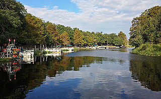
Camp Mack is a fishing lodge, RV resort campground and recreation event venue in the historic town of Lake Wales, Florida situated on the Kissimmee River, in the heart of the Kissimmee Chain of Lakes. In March, 2018 the lodge was rebranded Camp Mack, a Guy Harvey Lodge, Marina and RV Resort, affiliating itself with Guy Harvey Outpost Collection, the lodging arm of the noted marine scientist, artist, and conservation advocate Dr. Guy Harvey. The camp’s “old Florida” riverfront setting offers bass fishing enthusiasts access to Lake Kissimmee, Hatchineha, Cypress and Tohopekaliga and is host of numerous bass fishing tournaments. A variety of sporting and musical events use the riverfront setting as a backdrop, including Rockin’ on the River, an annual country music festival supporting autism. The Kissimmee River watershed comprises 3,000 square miles, supporting a diverse community of waterfowl, wading birds and other wildlife, in addition to its national reputation for holding trophy size largemouth bass.


