The Ouachita National Forest is a vast congressionally-designated National Forest that lies in the western portion of Arkansas and portions of extreme-eastern Oklahoma, USA.

Gifford Pinchot National Forest is a National Forest located in southern Washington, managed by the United States Forest Service. With an area of 1.32 million acres (5300 km2), it extends 116 km along the western slopes of Cascade Range from Mount Rainier National Park to the Columbia River. The forest straddles the crest of the South Cascades of Washington State, spread out over broad, old growth forests, high mountain meadows, several glaciers, and numerous volcanic peaks. The forest's highest point is at 12,276 ft. at the top of Mount Adams, the second tallest volcano in the state after Rainier. Often found abbreviated GPNF on maps and in texts, it includes the 110,000-acre (450 km2) Mount St. Helens National Volcanic Monument, established by Congress in 1982.

The Cherokee National Forest is a United States National Forest located in the U.S. states of Tennessee and North Carolina that was created on June 14, 1920. The forest is maintained and managed by the United States Forest Service. It encompasses an estimated area of 655,598 acres (2,653.11 km2).

The Monongahela National Forest is a national forest located in the Allegheny Mountains of eastern West Virginia, USA. It protects over 921,000 acres of federally managed land within a 1,700,000 acres proclamation boundary that includes much of the Potomac Highlands Region and portions of 10 counties.

The George Washington and Jefferson National Forests is an administrative entity combining two U.S. National Forests into one of the largest areas of public land in the Eastern United States. The forests cover 1.8 million acres (7,300 km2) of land in the Appalachian Mountains of Virginia, West Virginia, and Kentucky. Approximately 1 million acres (4,000 km2) of the forest are remote and undeveloped and 139,461 acres (564 km2) have been designated as wilderness areas, which prohibits future development.
The protected areas of Michigan come in an array of different types and levels of protection. Michigan has five units of the National Park Service system. There are 14 federal wilderness areas; the majority of these are also tribal-designated wildernesses. It has one of the largest state forest systems as well having four national forests. The state maintains a large state park system and there are also regional parks, and county, township and city parks. Still other parks on land and in the Great Lakes are maintained by other governmental bodies. Private protected areas also exist in the state, mainly lands owned by land conservancies.

De Soto National Forest, named for 16th-century Spanish explorer Hernando de Soto, is 518,587 acres of pine forests in southern Mississippi. It is one of the most important protected areas for the biological diversity of the Gulf Coast ecoregion of North America.

The Florida Trail is one of eleven National Scenic Trails in the United States. It currently runs 1,500 miles (2,400 km), from Big Cypress National Preserve to Fort Pickens at Gulf Islands National Seashore, Pensacola Beach. Also known as the Florida National Scenic Trail, the Florida Trail provides permanent non-motorized recreation opportunity for hiking and other compatible activities and is within an hour of most Floridians. The Florida National Scenic Trail is designated as a National Scenic Trail by the National Trails System Act of 1968.

The Sam Houston National Forest, one of four National Forests in Texas, is located 50 miles north of Houston. The forest is administered together with the other three United States National Forests and two National Grasslands located entirely in Texas, from common offices in Lufkin, Texas. The units include Angelina, Davy Crockett, Sabine, and Sam Houston National Forests, plus Caddo National Grassland and Lyndon B. Johnson National Grassland. There are local ranger district offices located in New Waverly. It is located in portions of three Texas counties including Montgomery, San Jacinto, and Walker.

The Opal Creek Wilderness is a wilderness area located in the Willamette National Forest in the U.S. state of Oregon, on the border of the Mount Hood National Forest. It has the largest uncut watershed in Oregon.

The Lake George State Forest is a designated protected area and state forest in the U.S. state of Florida. The 21,176-acre (8,570 ha) forest is located in northwestern Volusia County, Florida, near Lake George and the communities of Pierson, Barberville, and Volusia. It is overseen by the Florida Forest Service within the Florida Department of Agriculture and Consumer Services.
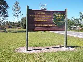
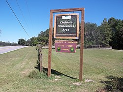
The Little Big Econ State Forest is a state forest in the U.S. state of Florida. The 5,048 acres (20.43 km2) forest is located in Central Florida, 3.3 miles (5.3 km) east of the downtown Oviedo, on Florida Country Road 426 with forest office on Snow Hill Road in Geneva, Florida. The Kilbee Tract is a smaller non-contiguous section of the park located east of the main forest, along Saint Johns River, the longest river in the state.

The Seminole State Forest is in the U.S. state of Florida. The 25,812-acre (10,446 ha) forest is located in Central Florida, near Eustis. Access to the forest is available from Florida State Road 44, Lake County Road 46A and Florida State Road 46. Surrounding parks and preserved areas include Lower Wekiva River Preserve State Park, Rock Springs Run State Reserve, Lake Norris Conservation Area, and the Ocala National Forest. The Florida National Scenic Trail runs through the from southeast to northwest.

The Withlacoochee State Forest is 157,479-acre (637 km2) in the western central part in the U.S. state of Florida, near Lecanto, Inverness, Floral City, Brooksville, Ridge Manor, and Dade City. The forest was named for the Withlacoochee River, which passes through some of the major tracts within.

The Wakulla State Forest is in the U.S. state of Florida. The 4,897-acre (20 km2) forest is located in the panhandle, near Tallahassee; it includes a major tract in Wakulla County and a small tract, the former Woodville State Forest, in Leon County. The forest is also a Wildlife Management Area managed by the Florida Fish and Wildlife Conservation Commission.

The Siuslaw National Forest is a national forest in western Oregon in the United States. Established in 1908, the Siuslaw is made up of a wide variety of ecosystems, ranging from coastal forests to sand dunes.
The Black Hammock Wilderness Area is a 700-acre (2.8 km2) joint purchase between Seminole County, Florida and the St. Johns River Water Management District. It was acquired as part of a comprehensive effort to preserve significant habitat along the shores of Lake Jesup. This particular area also helps protect important recharge areas for the Geneva Bubble. Additionally, the wetland habitats of this property filter water on its way to Lake Jesup

Big Shoals State Forest is a protected area of 1,629 acres (659 ha) just east of White Springs, Florida and adjacent to Big Shoals State Park in Hamilton County. The state forest area comprises the north part of the 3,919-acre (1,586 ha) Big Shoals Public Lands and contains the largest area of whitewater in Florida. It is in the area of the Suwannee River.
Orange County Parks and Recreation is the county park department in Orange County, Florida, United States. It maintains and operates a number of parks, multiuse trails, and community recreation centers.