| Koreshan State Park | |
|---|---|
IUCN category V (protected landscape/seascape) | |
 The Planetary Court | |
  | |
| Location | Lee County, Florida, United States |
| Nearest city | Estero, Florida |
| Coordinates | 26°26.0′N81°49.0′W / 26.4333°N 81.8167°W |
| Area | 135 acres (0.55 km2) |
| Governing body | Florida Department of Environmental Protection |
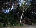
The Koreshan State Park is a state park in Estero, Florida located on U.S. Highway 41 at Corkscrew Road. It was also added to the National Register of Historic Places on May 4, 1976, under the designation of Koreshan Unity Settlement Historic District.
Contents
It contains areas of pine flatwoods habitat and the site of a religious colony, the Koreshan Unity, whose last members deeded the land to the state in 1961. [1]