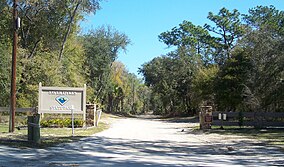
Goose Creek State Park is a North Carolina state park near Washington, Beaufort County, North Carolina in the United States. It covers 1,672 acres (6.77 km2) just off of Pamlico Sound, in North Carolina's Coastal Plain. Goose Creek State Park is home to a wide variety of wildlife that make their homes in the extensive salt water marshes, inlets and creeks on the northern side of the sound. Goose Creek State Park is open for year-round recreation, east of Washington, two miles (3 km) south of U.S. Route 264 on Camp Leach Road.

St. George Island State Park is a Florida State Park located on the east end of St. George Island, approximately 10 miles southeast of Eastpoint, in northwestern Florida.

Little Talbot Island State Park is a Florida State Park located on Little Talbot Island, 17 miles (27 km) northeast of Jacksonville on State Road A1A. The park covers the entire 2,500-acre (10 km2) island. Big Talbot Island State Park lies to the immediate north. The park contains maritime forests, dunes, and salt marshes on the western side of the island. Wild life includes river otters, marsh rabbits, bobcats, and a variety of native and migrating birds. Activities include camping, fishing, hiking, swimming, canoeing, nature watching and surfing. Erosion on Big Talbot Island, coupled with sand deposition on Little Talbot, have resulted in Little Talbot Island becoming the larger of the two Talbot Islands. The largest continuous section of the Machaba Balu Preserve lies just to the west of Little Talbot Island.

Collier–Seminole State Park is a Florida State Park located on US 41, 17 miles (27 km) south of Naples, Florida. The park is the home of a National Historic Mechanical Engineering Landmark, the Bay City Walking Dredge used to build the Tamiami Trail through the Everglades. The park includes of 6,430 acres (26 km2) of mangrove swamp, cypress swamps, salt marshes, mangrove river estuaries, and pine flatwoods. Among the wildlife of the park are American alligators, raccoons, ospreys, and American white ibis. brown pelicans, wood storks, bald eagles, red-cockaded woodpeckers, American crocodiles, Florida black bears and Big Cypress fox squirrels also inhabit the park.

Fort Cooper State Park is a 710-acre historic site in Inverness, Florida, United States. It is located two miles (3 km) south of Inverness, off of U.S. Hwy. 41 on South Old Floral City Road. On June 13, 1972, it was added to the United States National Register of Historic Places. It is also a Florida State Park.

Hugh Taylor Birch State Park is a Florida State Park located in Fort Lauderdale, on East Sunrise Boulevard, between the Intracoastal Waterway and SR A1A.
Gamble Rogers Memorial State Recreation Area is a 144-acre (0.58 km2) Florida State Park in Flagler Beach, Florida, United States, between the Atlantic Ocean and the Intra-Coastal Waterway on State Route A1A. It is about 18 miles (29 km) north of Daytona Beach and about 30 miles (48 km) south of St. Augustine.
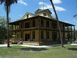
The Koreshan State Historic Site is a state park in Estero, Florida located on U.S. Highway 41 at Corkscrew Road. It was also added to the National Register of Historic Places on May 4, 1976, under the designation of Koreshan Unity Settlement Historic District.

Lake Griffin State Park is a Florida State Park located two miles (3 km) north of Leesburg, in Fruitland Park and 30 miles (48 km) south of Ocala on U.S. Highway 441. It is home to one of the state's largest live oak trees. The park is unique in connecting to Lake Griffin, the Ocklawaha River and thence to the Harris Chain of Lakes, and is made up of 577.63 acres (2.33758 km2) of swampland and hardwood upland.

Lake Kissimmee State Park is a 5,930-acre (24 km2) Florida State Park located north of State Road 60, 15 miles (24 km) east of Lake Wales. It contains floodplain, forest, prairie, hammock, flatwoods and Lakes Kissimmee, Tiger, and Rosalie. The park is home to 50 species of plants and animals that are either threatened, of special concern or endangered.

Little Manatee River State Park is a 2,433-acre (985 ha) Florida State Park located 5 miles (8.0 km) south of Sun City, off U.S. Route 301 on Lightfoot Road and along the Little Manatee River. The park was established in 1974 as Little Manatee River State Recreation Area with 663 hectares. It was designated as a state park in March 1999. The Florida Department of Environmental Protection's Division of Recreation and Parks manages that park under a 99-year lease, set to expire April 10, 2074.

Lovers Key State Park is a 712-acre (2.88 km2) Florida State Park located on Lover's Key and three other barrier islands—Black Island, Inner and Long Key. It is at 8700 Estero Blvd., Fort Myers Beach, between Big Carlos Pass and New Pass and 10.5 miles (16.9 km) west of Interstate 75 on exit 116. The park lies within the city limits of Bonita Springs and is just north of Bonita Beach. The park uses a Fort Myers Beach zip code for address purposes.

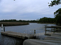
Werner-Boyce Salt Springs State Park is a Florida state park located in Pasco County, Florida near Port Richey, Florida, along the Gulf of Mexico on the Atlantic coastal plain. An entrance to this park is at the intersection of Scenic Drive and Cinema Drive, one mile west of the intersection of Cinema Drive/Ridge Manor Blvd. and U.S. Highway 19. The park is named, in part, for a 320 feet deep saltwater spring in the park, which is not yet easily accessible. The park includes four miles of Pasco County's coastal waters on the Gulf of Mexico.

Rainbow Springs State Park is a Florida state park located on U.S. 41, 3 miles (5 km) north of Dunnellon, Florida. It comprises 1,459.07 acres (5.9046 km2) upland and 12.83 acres (51,900 m2) submerged. The most significant natural feature is the first-magnitude headspring basin, which produces up to 600,000,000 US gallons (2,300,000 m3) of fresh water per day, forming the Rainbow River. The looking-glass waters of Rainbow Springs come from several vents, not one large bubbling spring. The river itself supports a wide variety of fish, wildlife, and plants, many within easy viewing by visitors. In total, the park contains 11 distinct natural communities, including sandhills, flatwoods, upland mixed forests, and hydric hammocks.

Tomoka State Park is an 2,000-acre (8.1 km2) Florida State Park located along the Tomoka River, three miles (5 km) north of Ormond Beach on North Beach Street.

In 1999, the Guana Tolomato Matanzas National Estuarine Research Reserve was designated in St. Johns and Flagler counties, Florida as a part of the National Oceanic and Atmospheric Administration (NOAA) National Estuarine Research Reserve (NERR) system. The GTM Research Reserve represents the east Florida sub-region of the Carolinian bioregion. It is one of 30 NERRs in 23 states and one territory. GTM is one of three NERRs in Florida and is administered on behalf of the state by the Florida Department of Environmental Protection's Florida Coastal Office as part of a network that includes forty-one aquatic preserves, three NERRs, a National Marine Sanctuary, the Coral Reef Conservation Program and the Florida Oceans and Coastal Council. Additional interests are held in the research and management of the GTM and connected preserved or conserved lands including:

Colt Creek State Park is a Florida State Park in Central Florida, 16 miles (26 km) north of Lakeland off of State Road 471. This 5,067 acre park nestled within the Green Swamp Wilderness Area and named after one of the tributaries that flows through the property was opened to the public on January 20, 2007. Composed mainly of pine flatwoods, cypress domes and open pasture land, this piece of pristine wilderness is home to many animal species including the American bald eagle, Southern fox squirrel, gopher tortoise, white-tailed deer, wild turkey and bobcat.
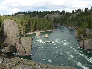
Riverside State Park is a Washington state park located 9 miles (14 km) northwest of Spokane in the community of Nine Mile Falls. The park protects 11,162 acres (4,517 ha) of Okanagan dry forest along the Spokane and Little Spokane rivers. It is the second largest state park in Washington after Mount Spokane State Park and is a popular recreation area for locals.

Daingerfield State Park is a 506.913-acre (2.05140 km2) state park in Morris County, Texas southwest of Texarkana, including 80-acre (320,000 m2) Lake Daingerfield. The park opened in 1938 and is managed by the Texas Parks and Wildlife Department.

Powhatan State Park is a state park located along the James River in Virginia. It is in Powhatan County. The park is 1,565 acres (6 km2) total with a 2-mile (3.2 km) of riverfront. One of the newest Virginia state parks, Powhatan opened in 2013 after a 10-year process of transferring it from use by the Virginia Department of Juvenile Justice to a Virginia state park.