Pinellas County is a county located on the west central coast of the U.S. state of Florida. As of the 2020 census, the population was 959,107. The county is part of the Tampa–St. Petersburg–Clearwater, Florida Metropolitan Statistical Area. Clearwater is the county seat. St. Petersburg is the largest city as well as the largest city in Florida that is not a county seat.
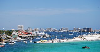
Destin is a city located in Okaloosa County, Florida. It is a principal city of the Crestview–Fort Walton Beach–Destin, Florida, metropolitan area.

Daytona Beach, or simply Daytona, is a city of about 73,000 residents in Central Florida on its Atlantic coast. In Volusia County, it is approximately 42 miles (67.6 km) northeast of Orlando, 64 miles (103.0 km) southeast of Jacksonville, and 231 miles (371.8 km) northwest of Miami. It is part of the Deltona–Daytona Beach–Ormond Beach metropolitan area which has a population of about 600,000 and is also a principal city of the Fun Coast region of Florida.
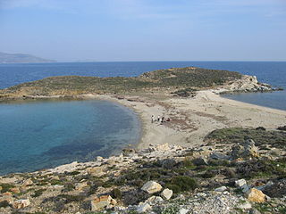
A tombolo is a sandy or shingle isthmus. A tombolo, from the Italian tombolo, meaning 'pillow' or 'cushion', and sometimes translated incorrectly as ayre, is a deposition landform by which an island becomes attached to the mainland by a narrow piece of land such as a spit or bar. Once attached, the island is then known as a tied island.

The Florida Panhandle is the northwestern part of the U.S. state of Florida; it is a strip of land roughly 200 miles (320 km) long and 50 to 100 miles wide, lying between Alabama on the north and the west, Georgia on the north, and the Gulf of Mexico to the south. Its eastern boundary is arbitrarily defined. In terms of population, major communities include Tallahassee, Pensacola, and Panama City.

Constitution Convention Museum State Park is a Florida State Park located just outside Port St. Joe, off US 98, in northwestern Florida. The 14-acre (57,000 m2) park contains a museum with examples of 19th-century life in the former town of St. Joseph, and features life-sized figures with audio presentations about the state's first Constitutional Convention. The address is 200 Allen Memorial Way.
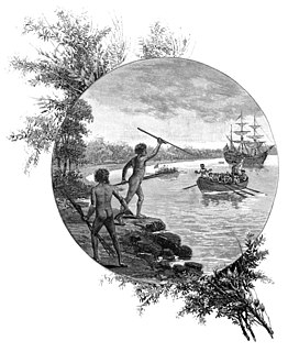
Kurnell is a suburb in Sydney, in the state of New South Wales, Australia. It is 21.4 kilometres (13.3 mi) south of the Sydney central business district, in the local government area of the Sutherland Shire along the east coast. Cronulla and Woolooware are the only adjacent suburbs. La Perouse is located opposite, on the northern headland of Botany Bay. The Cronulla sand dunes are on the south eastern headland of Botany Bay. The eastern side of the peninsula is part of Botany Bay National Park, and Towra Point Nature Reserve is located on the western side of the suburb.

State Road 30A (SR 30A) is a Florida Department of Transportation designation shared by four alternate routings of SR 30 in the Florida panhandle. Two segments have SR 30A signage; the other two do not as they are segments of U.S. Route 98 (US 98). Three of the four SR 30A segments are next to the shore of the Gulf of Mexico for most of their length.

State Road 30 is the mostly hidden Florida Department of Transportation designation for most of US 98 from the Florida-Alabama state line to east of Perry, Florida.

Presque Isle State Park is a 3,112-acre (1,259 ha) Pennsylvania State Park on an arching, sandy peninsula that juts into Lake Erie, 4 miles (6 km) west of the city of Erie, in Millcreek Township, Erie County, Pennsylvania, in the United States. The peninsula sweeps northeastward, surrounding Presque Isle Bay along the park's southern coast. It has 13 miles (21 km) of roads, 21 miles (34 km) of recreational trails, 13 beaches for swimming, and a marina. Popular activities at the park include swimming, boating, hiking, biking, and birdwatching.

The Long Beach Peninsula is an arm of land on the southern coast of the state of Washington in the United States. Entirely within Pacific County, it is bounded on the west by the Pacific Ocean, the south by the Columbia River, and the east by Willapa Bay. Leadbetter Point State Park and Willapa National Wildlife Refuge are at the northern end of the peninsula and Cape Disappointment is at the southern end, with Pacific Pines State Park located in between.
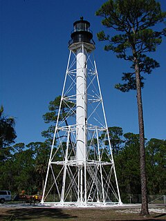
The Cape San Blas Light is a lighthouse in the state of Florida in the United States. There were four built between 1849 and 1885. It was located at Cape San Blas in the northwestern part of the state. Due to beach erosion and weather damage over the decades, it was moved in 2014 to Port St. Joe. The lighthouse was listed on the National Register of Historic Places in 2015.

Anastasia State Park is a 1,600-acre (6.5 km2) state park in Florida, United States. Its location is on a peninsula on Anastasia Island across Matanzas Bay from downtown St. Augustine along the Atlantic coastal plain. This park has a variety of wildlife, birds and plants in a setting of beaches, tidal salt marsh, and marine and upland hammock.
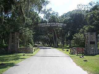
Dade Battlefield Historic State Park is a state park located on County Road 603 between Interstate 75 and U.S. Route 301 in Sumter County, Florida. The 80-acre (32 ha) park includes 40 acres (160,000 m2) of pine flatwoods and a live oak hammock. Also called the Dade Massacre site, it preserves the Second Seminole War battlefield where tribal Seminole warriors fought soldiers under the command of Major Francis L. Dade on December 28, 1835. Each year, on the weekend after Christmas, the Dade Battlefield Society sponsors a reenactment of the battle that started the Second Seminole War.
Gamble Rogers Memorial State Recreation Area is a 144-acre (0.58 km2) Florida State Park in Flagler Beach, Florida, United States, between the Atlantic Ocean and the Intra-Coastal Waterway on State Route A1A. It is about 18 miles (29 km) north of Daytona Beach and about 30 miles (48 km) south of St. Augustine.

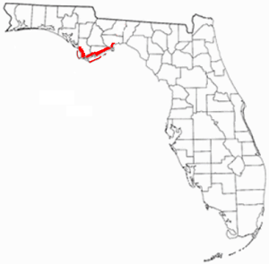
The St. Joseph Peninsula is located in Gulf County, Florida, in the Florida Panhandle, at coordinates 29°42′55″N85°23′05″W. It is a 15-mile long spit, extending northward from Cape San Blas between the Gulf of Mexico to the west and St. Joseph Bay to the east. It is 6 miles west of Port St. Joe at its closest point. The peninsula is also known as St. Joseph Spit. The northern end of the peninsula is known as St. Joseph Point.
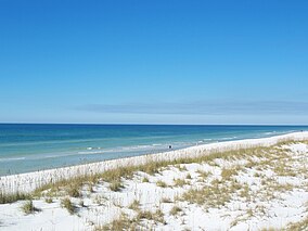
The Forgotten Coast refers to a largely untouched and uninhabited area of coastline in the panhandle of the US state of Florida. The term, also a trademark, was first used in 1992, but the Forgotten Coast's exact location is not agreed upon.
Bahia Honda is an island in the lower Florida Keys.
Clearwater Beach includes a resort area and a residential area on a barrier island in the Gulf of Mexico in Pinellas County on the west-central coast of Florida. Located just west over the Intracoastal Waterway by way of the Clearwater Memorial Causeway from the rest of the city of Clearwater, Florida, of which it is part, Clearwater Beach is at a geographic latitude of 27.57 N and longitude 82.48 W.

The following is an alphabetical list of articles related to the U.S. state of Florida.