Related Research Articles

The Apalachicola River is a river, approximately 160 mi (180 km) long in the state of Florida. The river's large watershed, known as the ACF River Basin, drains an area of approximately 19,500 square miles (50,500 km2) into the Gulf of Mexico. The distance to its farthest head waters in northeast Georgia is approximately 500 miles (800 km). Its name comes from the Apalachicola people, who used to live along the river. It is the largest river in Florida.

Myakka River State Park is a Florida State Park, that is located nine miles (14 km) east of Interstate 75 in Sarasota County and a portion of southeastern Manatee County on the Atlantic coastal plain. This state park consists of 37,000 acres (150 km2), making it one of the state's largest parks. It is also one of the oldest parks in the state. It was delineated in the 1930s by the Civilian Conservation Corps. A small portion of the park was the gift of the family of Bertha Palmer to the state. The park is named after the Myakka River.

The Apalachicola National Forest is the largest U.S. National Forest in the state of Florida. It encompasses 632,890 acres and is the only national forest located in the Florida Panhandle. The National Forest provides water and land-based outdoors activities such as off-road biking, hiking, swimming, boating, hunting, fishing, horse-back riding, and off-road ATV usage.

Tate's Hell State Forest is 202,000 acres (819 km²) of land in Franklin and Liberty counties in Florida. The forest is located near Carrabelle off US 98 along the Gulf coast and on St. James Island. At one time, Tate's Hell supported at least 12 major habitats including: wet flatwoods, wet prairie, seepage slope, baygall, floodplain forest, floodplain swamp, basin swamp, upland hardwood forest, sandhill, pine ridges, dense titi swamp thickets and scrub. Tate's Hell State Forest is an important hydrologic area and includes a section of the New River. The park's watershed provides fresh water into the Apalachicola Bay, the Carrabelle River and the Ochlockonee River.

Lake Kissimmee State Park is a 5,930-acre (24 km2) Florida State Park located north of State Road 60, 15 miles (24 km) east of Lake Wales. It contains floodplain, forest, prairie, hammock, flatwoods and Lakes Kissimmee, Tiger, and Rosalie. The park is home to 50 species of plants and animals that are either threatened, of special concern or endangered.

Tosohatchee Wildlife Management Area is located along the St. Johns River east of Orlando in Christmas on Taylor Creek Road, off SR 50.
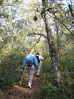
The Florida Trail is one of eleven National Scenic Trails in the United States. It currently runs 1,000 miles (1,600 km), with 300 miles (480 km) planned, from Big Cypress National Preserve to Fort Pickens at Gulf Islands National Seashore, Pensacola Beach. Also known as the Florida National Scenic Trail, the Florida Trail provides permanent non-motorized recreation opportunity for hiking and other compatible activities and is within an hour of most Floridians. The Florida National Scenic Trail is designated as a National Scenic Trail by the National Trails System Act of 1968.
In 1999, the Guana Tolomato Matanzas National Estuarine Research Reserve was designated in St. Johns and Flagler counties, Florida as a part of the National Oceanic and Atmospheric Administration (NOAA) National Estuarine Research Reserve (NERR) system. The GTM Research Reserve represents the east Florida sub-region of the Carolinian bioregion. It is one of 29 NERRs in 23 states and one territory. GTM is one of three NERRs in Florida, and is administered on behalf of the state by the Florida Department of Environmental Protection's Florida Coastal Office as part of a network that includes forty-one aquatic preserves, three NERRs, a National Marine Sanctuary, the Coral Reef Conservation Program and the Florida Oceans and Coastal Council. Additional interests are held in the research and management of the GTM and connected preserved or conserved lands including:
The Econlockhatchee River is an 87.7-kilometer-long (54.5 mi) north-flowing blackwater tributary of the St. Johns River. The Econ River flows through Osceola, Orange, and Seminole counties in Central Florida, just east of the Orlando Metropolitan Area. It is a designated Outstanding Florida Waters.

Little Econlockhatchee River is a major tributary of the Econlockhatchee River. It originates at an unnamed lake at 28°33′47″N81°17′00″W, near Orlando, Florida in southeast Orange County. It is approximately 18 miles (29 km) long, from unincorporated Orange County to its mouth at Oviedo. It is located within the Middle St. Johns River Basin of the St. Johns River Water Management District. It is similar to the Econlockhatchee, with a forest in its floodplain. As far downstream as Blanchard Park, the river acts like a canal. The source elevation is 72 feet (22 m), higher than the source elevation of the tributary of the St. Johns River, the Econlockhatchee River. In August 2008, the river rose a record 4 feet (1.2 m) over its banks due to Tropical Storm Fay.

The Ralph E. Simmons Memorial State Forest is in the U.S. state of Florida. The 3,638-acre (15 km2) forest is located in northeastern Florida, near Hilliard. The forest was renamed in 1996 for Ralph E. Simmons, a former member of the St. Johns River Water Management District Governing Board.

The Tiger Bay State Forest is in the U.S. state of Florida. The 27,330-acre (11,060 ha) forest is located in Volusia County, Florida, between Daytona Beach and DeLand.

The Wakulla State Forest is in the U.S. state of Florida. The 4,897-acre (20 km2) forest is located in the panhandle, near Tallahassee; it includes a major tract in Wakulla County and a small tract, the former Woodville State Forest, in Leon County. The forest is also a Wildlife Management Area managed by the Florida Fish and Wildlife Conservation Commission.

Colt Creek State Park is a Florida State Park in Central Florida, 16 miles (26 km) north of Lakeland off of State Road 471. This 5,067 acre park nestled within the Green Swamp Wilderness Area and named after one of the tributaries that flows through the property was opened to the public on January 20, 2007. Composed mainly of pine flatwoods, cypress domes and open pasture land, this piece of pristine wilderness is home to many animal species including the American bald eagle, Southern fox squirrel, gopher tortoise, white-tailed deer, wild turkey and bobcat.
The Black Hammock Wilderness Area is a 700-acre (2.8 km2) joint purchase between Seminole County, Florida and the St. Johns River Water Management District. It was acquired as part of a comprehensive effort to preserve significant habitat along the shores of Lake Jesup. This particular area also helps protect important recharge areas for the Geneva Bubble. Additionally, the wetland habitats of this property filter water on its way to Lake Jesup
Cottage Hill State Forest is located in Escambia County, Florida. In 2013 it was reported that the lands might be sold to raise money.
Deep Creek Conservation Area is an area of protected lands near Hastings, Florida in St. Johns County and Putnam County that is managed by the St. Johns River Water Management District.
Deep Creek State Forest (DCSF) is a 380-acre state forest 11 miles north of St. Augustine, Florida in St. Johns County, Florida. Deep Creek State Forest is located on both sides of Deep Creek, for which it is named. The state forest is west of the Guana River Wildlife Management Area across the Intracoastal Waterway.
The Holopaw State Forest is in the U.S. state of Florida. The 58-acre forest is located off U.S. Route 192 in Central Florida, within the unincorporated town of Holopaw, Florida in Osceola County, Florida.
References
- 1 2 10 year management plan Watson Island State Forest Florida Division of Agriculture and Consumer Services, Division of Forestry
- ↑ Consider a 10-year Management Plan for Watson Island State Forest December 3, 2007 Florida Department of Environmental Protection
- ↑ Florida Forever Management Prospectus St Johns River Blueway, Division of Forestry