Jupiter Island is a barrier island on the coast of Martin and Palm Beach counties, Florida. It is bounded on the east by the Atlantic Ocean, on the north by the St. Lucie Inlet, on the west by the Indian River, and on the south by the Jupiter Inlet. Jupiter Island originally was two islands, Long Island on the north and Jupiter Island on the south, which were once separated by an inlet in the vicinity of North Jupiter Narrows and what is officially called Peck Lake, but commonly called Peck's Lake.

The Indian River Lagoon is a grouping of three lagoons: the Mosquito Lagoon, the Banana River, and the Indian River, on the Atlantic Coast of Florida; one of the most biodiverse estuaries in the Northern Hemisphere and is home to more than 4,300 species of plants and animals.

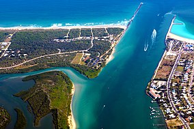
The St. Lucie Inlet, Florida is located between Hutchinson Island and Jupiter Island in Martin County, Florida, at coordinates 27°09′58″N80°09′24″W. The St. Lucie Inlet is one of six inlets into the Indian River Lagoon.
State Road 707 is a former state road on Florida's Treasure Coast, which is now County Road 707. The last state-maintained section, extending 2 miles (3.2 km) from the south end of the Old Roosevelt Bridge in Stuart to the intersection of Savannah Road near Rio, was transferred to the city of Stuart in 2012 or 2013.

Little Talbot Island State Park is a Florida State Park located on Little Talbot Island, 17 miles (27 km) northeast of Jacksonville on State Road A1A. The park covers the entire 2,500-acre (10 km2) island. Big Talbot Island State Park lies to the immediate north. The park contains maritime forests, dunes, and salt marshes on the western side of the island. Wild life includes river otters, marsh rabbits, bobcats, and a variety of native and migrating birds. Activities include camping, fishing, hiking, swimming, canoeing, nature watching and surfing. Erosion on Big Talbot Island, coupled with sand deposition on Little Talbot, have resulted in Little Talbot Island becoming the larger of the two Talbot Islands. The largest continuous section of the Machaba Balu Preserve lies just to the west of Little Talbot Island.

Big Talbot Island State Park is a state park in Florida, United States. It is located on Big Talbot Island, 20 miles east of downtown Jacksonville on A1A North and immediately north of Little Talbot Island State Park along the Atlantic coastal plain.
The Fort Clinch State Park is a Florida State Park, located on a peninsula near the northernmost point of Amelia Island, along the Amelia River. Its 1,100 acres (4 km2) include the 19th-century Fort Clinch, sand dunes, plains, maritime hammock and estuarine tidal marsh. The park and fort lie to the northeast of Fernandina Beach at the entrance to the Cumberland Sound.
Fort Cooper State Park is a 710-acre historic site in Inverness, Florida, United States. It is located two miles (3 km) south of Inverness, off of U.S. Hwy. 41 on South Old Floral City Road. On June 13, 1972, it was added to the United States National Register of Historic Places. It is also a Florida State Park.
Fort George Island State Cultural Site is a Florida State Park located on Fort George Island, about three miles (5 km) south of Little Talbot Island State Park on SR A1A. It is home to the Ribault Inn Club, constructed in 1928 as a winter resort and now used as a visitor's center. The 46,000-acre (190 km2) Timucuan Ecological and Historic Preserve, in Jacksonville, Florida is nearby. Fort George has the highest point along the Atlantic coast south of Sandy Hook, New Jersey, and contains Timucua oyster shell mounds. The park is part of the Talbot Islands GEOpark complex.

Hontoon Island State Park is a 1,648-acre (6.67 km2) Florida State Park located on Hontoon Island between the St. Johns River and the Hontoon Dead River in Volusia County. It is six miles (10 km) west of DeLand, off SR 44, and can only be reached by boat or park-operated passenger ferry. No motorized vehicles, other than wheelchairs, are allowed to be brought onto the island and there is no swimming. The island has pine flatwoods, palm and oak hammocks, bald cypress swamps and marshes. Hontoon Island is surrounded by the St. Johns River, the Hontoon Dead River, and Snake Creek.
Lovers Key State Park is a 712-acre (2.88 km2) Florida State Park located on Lover's Key and three other barrier islands—Black Island, Inner and Long Key. It is at 8700 Estero Blvd., Fort Myers Beach, between Big Carlos Pass and New Pass and 10.5 miles (16.9 km) west of Interstate 75 on exit 116. The park lies within the city limits of Bonita Springs and is just north of Bonita Beach. The park uses a Fort Myers Beach zip code for address purposes.

Three Rivers Park District is a special park district serving the suburban areas of the Twin Cities including suburban Hennepin, Carver, Dakota, Scott and Ramsey counties. Three Rivers's mission is "To promote environmental stewardship through recreation and education in a natural resources-based park system." Three Rivers operates twenty parks and ten regional trails, with at least two more regional trails planned. Nearly seven million people visit Three Rivers facilities each year.
Tomoka State Park is an 2,000-acre (8.1 km2) Florida State Park located along the Tomoka River, three miles (5 km) north of Ormond Beach on North Beach Street.
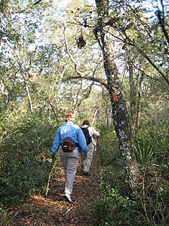
The Florida Trail is one of eleven National Scenic Trails in the United States. It currently runs 1,000 miles (1,600 km), with 300 miles (480 km) planned, from Big Cypress National Preserve to Fort Pickens at Gulf Islands National Seashore, Pensacola Beach. Also known as the Florida National Scenic Trail, the Florida Trail provides permanent non-motorized recreation opportunity for hiking and other compatible activities and is within an hour of most Floridians. The Florida National Scenic Trail is designated as a National Scenic Trail by the National Trails System Act of 1968.
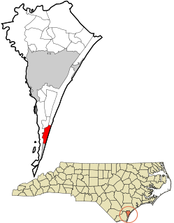
Pleasure Island is a coastal barrier island in Southeastern North Carolina, USA just south of the City of Wilmington. Most of Pleasure Island is located within Federal Point Township, in New Hanover County, but its southernmost tip extends into Smithville Township, in Brunswick County. The coastal resort towns of Carolina Beach and Kure Beach, as well as the annexed communities of Wilmington Beach and Hanby Beach are located on the island. The southern end of Pleasure Island was separated from Bald Head Island by Corncake Inlet until the inlet was shoaled and closed in 1998 by Hurricane Bonnie; thus Pleasure Island and Bald Head Island are no longer separate islands.
Known for beautiful beaches, nature preserves and parks, Hutchinson Island consists of two barrier islands on the coast of Martin, St. Lucie, and Indian River counties, Florida. The two islands are separated by the Fort Pierce Inlet and are known as North Hutchinson Island and South Hutchinson Island. North Hutchinson Island is divided into two counties - Indian River County and St. Lucie County. The Indian River county portion of North Hutchinson Island which extends to the Sebastian Inlet is sometimes called Orchid Island, although it is not a separate island. See the Wikipage for North Hutchinson Island for more information.
North Hutchinson Island is an Atlantic coastal barrier island on the east coast of Florida in the United States. The island is known for clean expansive beaches, wildlife preserves, parks, shops and restaurants.

Blue Lake Regional Park is a public park in Fairview, in the U.S. state of Oregon. The 101-acre (41 ha) park, near the south shore of the Columbia River in Multnomah County, includes many covered and uncovered picnic areas, playing fields for sports such as softball, a cross country course and infrastructure related to lake recreation including swimming, boating, and fishing. Encompassing wooded areas, three ponds, and a wetland in addition to the lake, the park is frequented by migrating birds and other wildlife. Paved paths run through the park, which is near the 40-Mile Loop hiking and biking trail. Park vegetation includes cottonwoods, willows, and other trees and shrubs as well as wetland plants such as cattails.

Penrose Point State Park is a 165-acre (67 ha) Washington state park located on Mayo Cove and Carr Inlet at the southern end of Puget Sound in Pierce County. The park has over 2 miles (3.2 km) of saltwater shoreline as well as 2.5 miles (4.0 km) of hiking and biking trails and an interpretive nature trail. Park activities include picnicking, boating, scuba diving, fishing, swimming, waterskiing, clam digging, crabbing, beachcombing, birdwatching, wildlife viewing, and horseshoes. The park was named after Dr. Stephen Penrose, the president of Whitman College in Walla Walla from 1884 to 1934.