Weedon Island Preserve

Last updated
Weedon Island Preserve
IUCN category V (protected landscape/seascape)
Weeden Island01.jpg
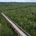
View of the preserve from top of observation tower
USA Florida relief location map.jpg
Red pog.svg
Weedon Island Preserve
Location Pinellas County, Florida, USA
Nearest city St. Petersburg, Florida
Coordinates 27°50′42″N82°36′07″W / 27.84500°N 82.60194°W / 27.84500; -82.60194
EstablishedJune 13, 1972
Governing bodyPinellas County Park Department
Weedon Island Preserve
NRHP reference No. 72000347 [1]

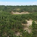
The Weedon Island Preserve is a 3,190-acre natural area situated along the western shore of Tampa Bay and located at 1800 Weedon Drive NE, St. Petersburg, Florida, United States. It is predominately an estuarine preserve composed of upland and aquatic ecosystems such as mangrove forests, pine/scrubby flatwoods, and maritime hammocks, and is home to a variety of native wildlife. The preserve is also a designated archaeological area, with several shell mounds identified on the property that provide evidence of early peoples who inhabited the land for thousands of years.

Contents

On June 13, 1972, Weedon Island Preserve was added to the U.S. National Register of Historic Places. In 1974, the state of Florida purchased Weedon Island and its surrounding islands, which were officially opened for public use in December 1980. In 1993, the state created a lease agreement with Pinellas County to manage and maintain the preserve. The county's Department of Parks and Conservation Resources presently manages the area.

Weedon Island Preserve's name is derived from Tampa doctor and amateur archaeologist Leslie Washington Weedon. [2]

Recreational activities

The preserve offers a total of 4.7 miles of nature trails for hiking, with 2 miles out of the total as boardwalks and paved trails that are ADA accessible and the remaining 2.7 miles as natural trail loops. The 3,000-foot Tower Boardwalk trail leads visitors to a 45-foot-tall observation tower, the tallest of its kind in Pinellas County. With favorable weather conditions, one can see much of the preserve and Tampa Bay from this tower, as well as the cities of Tampa and St. Petersburg. Three additional observation platforms along the trails offer opportunities for bird and wildlife viewing and are ideal for photography.

In addition to hiking, the preserve maintains a 4-mile, self-guided canoeing/kayaking loop called the South Paddling Trail. The path weaves through mangrove tunnels within the preserve and has access points to the bay. Visitors interested in exploring the paddling trail may bring their own vessels or take a tour.

Other activities available include fishing from the pier located at the end of Weedon Dr. NE and picnicking at any of the designated picnic tables provided.

Weedon Island Preserve 360 Degree Panorama from Observation Tower.jpg
View from observation tower. Visible items on horizon, from left to right include: downtown St. Petersburg, Florida; WGES (AM) Antenna; Bartow Power Plant; downtown Tampa, Florida; MacDill Air Force Base; Big Bend Power Station.

Weedon Island Preserve Cultural and Natural History Center

The Weedon Island Preserve Cultural and Natural History Center opened in the fall of 2002 with the support of the Friends of Weedon Island and is run by Pinellas County. The Center focuses on the natural, cultural, and archaeological history of the preserve. [3] The Exhibit Hall features interactive displays on the unique wildlife and habitats found on Weedon Island and the ancient and present-day history of the preserve. Part of the collection of Native American artifacts from Weedon Island has been digitized and is available online as a virtual tour.

The most recent addition to the center is a 40 feet (12 m) dugout canoe that was found in the Weedon Island Preserve and is believed to be a Manasotan artifact. It is estimated to be 1,100 years old. [4]

Ecosystem

The Weedon Island Preserve ecosystems are majority wetlands, including mangrove swamps, with 1,100 acres (4.5 km2) of upland habitat. [5] Flatwoods are represented with pine and scrub, as are coastal hammocks, [6] coastal berms and anthropogenic shell mounds. [7] :1–5

Programs and events

Pinellas County staff and UF/IFAS Extension agents provide a wide variety of educational programs and events for the general public that are family-friendly and often free of charge. Monthly programs may include guided hikes, archaeology classes, speaker series, photography or birding meet-ups, and environmental sustainability workshops. Program registration and an updated list of current offerings are available through the preserve's Eventbrite page.

Hours of operations

The preserve is open seven days a week, from dawn to dusk. The Cultural and Natural History Center is open Thursdays through Saturdays from 9:00 a.m. to 4:00 p.m., and on Sundays from 11:00 a.m. to 4:00 p.m.

Related Research Articles

<span class="mw-page-title-main">Myakka River State Park</span> State park in Florida, United States

Myakka River State Park is a Florida State Park, that is located nine miles (14 km) east of Interstate 75 in Sarasota County and a portion of southeastern Manatee County on the Atlantic coastal plain. This state park consists of 37,000 acres (150 km2), making it one of the state's largest parks. It is also one of the oldest parks in the state. It was delineated in the 1930s by the Civilian Conservation Corps. A small portion of the park was the gift of the family of Bertha Palmer to the state. The park is named after the Myakka River.

<span class="mw-page-title-main">Big Lagoon State Park</span> State park in Florida, United States

First acquired in 1977, Big Lagoon State Park is a 705-acre (2.85 km2) Florida State Park located on the northwestern Florida coast, approximately 10 miles (16 km) southwest of Pensacola on Gulf Beach Highway. It encompasses the northern boundary of Big Lagoon as it snakes toward Pensacola Bay to the east. Wild Grande Lagoon and its minor tributaries lay within the boundaries of the park, as does the alligator-inhabited Long Pond, a man-made freshwater pond.

<span class="mw-page-title-main">Arboretum of the University of Central Florida</span> Arboretum in Orlando, Florida, U.S.

The Arboretum of the University of Central Florida is located on the main campus of the University of Central Florida in Orlando, Florida, United States. Covering 80 acres (320,000 m2), it contains more than 600 species of plants, including more than 100 bromeliads, in cultivated gardens.

<span class="mw-page-title-main">Fort De Soto Park</span> County park in Florida, USA

South-southwest of St. Petersburg, Florida, Fort De Soto Park is a park operated by Pinellas County on five offshore keys, or islands: Madelaine Key, St. Jean Key, St. Christopher Key, Bonne Fortune Key and the main island, Mullet Key. The keys are connected by either bridge or causeway. The island group is accessible by toll road from the mainland. Historically, the islands were used for military fortifications; remnants and a museum exhibit this history. Two piers, beaches, picnic area, hiking trails, bicycling trails, kayak trail, and a ferry to Egmont Key State Park are available.

<span class="mw-page-title-main">Jonathan Dickinson State Park</span> Park in Florida, US

Jonathan Dickinson State Park is a Florida State Park and historic site located in Martin County, Florida, between Hobe Sound and Tequesta. The park includes the Elsa Kimbell Environmental Education and Research Center and a variety of natural habitats: sand pine scrub, pine flatwoods, mangroves, and river swamps. The Loxahatchee River, designated a National Wild and Scenic River in 1985, runs through the park. The park is also along the Ocean to Lake Trail. The park is at 16450 S.E. Federal Highway, Hobe Sound. The park is well known for its Camp Murphy Mountain Bike Trails.

<span class="mw-page-title-main">Oscar Scherer State Park</span> State park in Florida, United States

Oscar Scherer State Park is a Florida State Park located between Sarasota and Venice, near Osprey. The address is 1843 South Tamiami Trail. There are more than 250,000 visitors a year.

<span class="mw-page-title-main">Collier–Seminole State Park</span> State park in Florida, United States

Collier–Seminole State Park is a Florida State Park located on US 41, 17 miles (27 km) south of Naples, Florida. The park is the home of a National Historic Mechanical Engineering Landmark, the Bay City Walking Dredge used to build the Tamiami Trail through the Everglades. The park includes of 6,430 acres (26 km2) of mangrove swamp, cypress swamps, salt marshes, mangrove river estuaries, and pine flatwoods. Among the wildlife of the park are American alligators, raccoons, ospreys, and American white ibis. brown pelicans, wood storks, bald eagles, red-cockaded woodpeckers, American crocodiles, Florida black bears and Big Cypress fox squirrels also inhabit the park.

<span class="mw-page-title-main">Fort Clinch State Park</span> State park in Florida, United States

The Fort Clinch State Park is a Florida State Park, located on a peninsula near the northernmost point of Amelia Island, along the Amelia River. Its 1,100 acres (4 km2) include the 19th-century Fort Clinch, sand dunes, plains, maritime hammock and estuarine tidal marsh. The park and fort lie to the northeast of Fernandina Beach at the entrance to the Cumberland Sound.

<span class="mw-page-title-main">Hontoon Island State Park</span> State park in Florida, United States

Hontoon Island State Park is a 1,648-acre (6.67 km2) Florida State Park located on Hontoon Island between the St. Johns River and the Hontoon Dead River in Volusia County. It is six miles (10 km) west of DeLand, off SR 44, and can only be reached by boat or park-operated passenger ferry. No motorized vehicles, other than wheelchairs, are allowed to be brought onto the island and there is no swimming. The island has pine flatwoods, palm and oak hammocks, bald cypress swamps and marshes. Hontoon Island is surrounded by the St. Johns River, the Hontoon Dead River, and Snake Creek.

<span class="mw-page-title-main">Florida Trail</span> A US National Scenic trail

The Florida Trail is one of eleven National Scenic Trails in the United States. It currently runs 1,500 miles (2,400 km), from Big Cypress National Preserve to Fort Pickens at Gulf Islands National Seashore, Pensacola Beach. Also known as the Florida National Scenic Trail, the Florida Trail provides permanent non-motorized recreation opportunity for hiking and other compatible activities and is within an hour of most Floridians. The Florida National Scenic Trail is designated as a National Scenic Trail by the National Trails System Act of 1968.

<span class="mw-page-title-main">Guana Tolomato Matanzas National Estuarine Research Reserve</span>

In 1999, the Guana Tolomato Matanzas National Estuarine Research Reserve was designated in St. Johns and Flagler counties, Florida as a part of the National Oceanic and Atmospheric Administration (NOAA) National Estuarine Research Reserve (NERR) system. The GTM Research Reserve represents the east Florida sub-region of the Carolinian bioregion. It is one of 30 NERRs in 23 states and one territory. GTM is one of three NERRs in Florida and is administered on behalf of the state by the Florida Department of Environmental Protection's Florida Coastal Office as part of a network that includes forty-one aquatic preserves, three NERRs, a National Marine Sanctuary, the Coral Reef Conservation Program and the Florida Oceans and Coastal Council. Additional interests are held in the research and management of the GTM and connected preserved or conserved lands including:

<span class="mw-page-title-main">Colt Creek State Park</span> State park in Florida, United States

Colt Creek State Park is a Florida State Park in Central Florida, 16 miles (26 km) north of Lakeland off of State Road 471. This 5,067 acre park nestled within the Green Swamp Wilderness Area and named after one of the tributaries that flows through the property was opened to the public on January 20, 2007. Composed mainly of pine flatwoods, cypress domes and open pasture land, this piece of pristine wilderness is home to many animal species including the American bald eagle, Southern fox squirrel, gopher tortoise, white-tailed deer, wild turkey and bobcat.

Hal Scott Regional Preserve and Park is a 9,515-acre (38.51 km2) nature preserve located along the banks of the Econlockhatchee River in east Orange County, Florida, United States. The Preserve is bordered by the Econlockhatchee on the West and Wedgefield, Florida on the East. It is managed by the St. Johns River Water Management District and Orange County Parks and Recreation. Recreational amenities include camping, hiking, horseback riding, mountain biking, fishing, and wildlife viewing.

The Black Hammock Wilderness Area is a 700-acre (2.8 km2) joint purchase between Seminole County, Florida and the St. Johns River Water Management District. It was acquired as part of a comprehensive effort to preserve significant habitat along the shores of Lake Jesup. This particular area also helps protect important recharge areas for the Geneva Bubble. Additionally, the wetland habitats of this property filter water on its way to Lake Jesup

<span class="mw-page-title-main">Frenchman's Forest Natural Area</span> Nature reserve in Florida

Frenchman's Forest Natural Area is a 158-acre (64 ha) protected area of pine flatwoods, strand swamp, scrubby flatwoods, hydric hammock tidal swamp and wet flatwoods in Palm Beach Gardens, Florida. It is located at 12201 Prosperity Farms Road. There are hiking trails and a boardwalk.

<span class="mw-page-title-main">Boyd Hill Nature Preserve</span>

Boyd Hill Nature Preserve is a 245-acre (99 ha) protected area in St. Petersburg, Florida, Pinellas County, Florida. The preserve is located on the shores of Lake Maggiore (Florida) in south St. Petersburg. It is operated by St. Petersburg Parks and Recreation and includes the Boyd Hill Environmental Center, a bird-of-prey aviary, and more than three miles of trails through a variety of ecosystems. Facilities include a playground and picnic areas. The preserve is used for school field trips and hosts environmental education programs. It is located at 1101 Country Club Way South.

<span class="mw-page-title-main">Boca Ciega Bay</span> Body of water in Florida

Boca Ciega Bay is a body of water connected to the Gulf of Mexico on the west-central coast of Florida. It is bordered by Gulfport, St. Petersburg, and other municipalities in Pinellas County. Clam Bayou estuary feeds into the bay.

<span class="mw-page-title-main">Weedon Island, Florida</span> Place in Florida, United States

Weedon Island is located in Pinellas County, Florida, United States. It is located within the Weedon Island Preserve, in the northern portion of the city of St. Petersburg, on the western coast of Old Tampa Bay. Weedon Island is archaeologically significant as it serves as a type-site for the Weeden Island Culture. Weedon Island is named for its early owner Dr. Leslie Weedon.

<span class="mw-page-title-main">Wall Springs Park</span>

Wall Springs Park is a 210-acre (0.85 km2) park located in Palm Harbor, Florida. The park includes a historical natural spring which was used as a bathing area from the turn of the 20th century until the 1960s. The park is located in Pinellas County, on the Florida Gulf Coast.

References

  1. "National Register Information System". National Register of Historic Places . National Park Service. July 9, 2010.
  2. The Weedon Island Story (PDF) (3rd ed.). 2005.
  3. http://www.weedonislandcenter.org/ Weedon Island Center, accessed January 21, 2008
  4. "1,100-Year-Old Prehistoric Canoe Found in Pinellas County, Florida" (PDF). Retrieved 1 January 2015.
  5. "Ecosystems". Discover Paradise in Pinellas County. Pinellas County. Retrieved 21 August 2023.
  6. "Weedon Island Preserve Visitor Guide" (PDF). Pinellas County Government. Retrieved 21 August 2023.
  7. "The Weedon Island Story" (PDF) (3rd ed.). Tarpon Springs, Florida: Pinellas County Department of Environmental Management, Environmental Lands Division. April 2005. Retrieved 21 August 2023.