Pinellas County is located on the west central coast of the state of Florida. As of the 2010 census, the population was 916,542. The county is part of the Tampa–St. Petersburg–Clearwater, Florida Metropolitan Statistical Area. Clearwater is the county seat, and St. Petersburg is the largest city and the largest city in Florida that is not a county seat.

Tierra Verde is a census-designated place (CDP) in Pinellas County, Florida, United States. The population was 3,721 at the 2010 census. The community is located on an island near the entrance of Tampa Bay, and is connected by the bridges of the Pinellas Bayway to both St. Petersburg and St. Pete Beach. At the southern end of Tierra Verde is Fort De Soto, a county park.

St. Pete–Clearwater International Airport is a public/military airport in Pinellas County, Florida serving the Tampa Bay Area. It is right on the northeast municipal boundary of Pinellas Park, 9 miles (14 km) north of downtown St. Petersburg, 7 miles (11 km) southeast of Clearwater, and 17 miles (27 km) southwest of Tampa.

Tampa Bay is a large natural harbor and shallow estuary connected to the Gulf of Mexico on the west central coast of Florida, comprising Hillsborough Bay, McKay Bay, Old Tampa Bay, Middle Tampa Bay, and Lower Tampa Bay. The largest freshwater inflow into the bay is the Hillsborough River, which flows into Hillsborough Bay in downtown Tampa. Many other smaller rivers and streams also flow into Tampa Bay, resulting in a large watershed area.

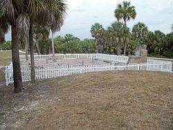
Letchworth Mounds Archaeological State Park is a 188.2 acre Florida State Park that preserves the state's tallest prehistoric, Native American ceremonial earthwork mound, which is 46 feet (14 m) high. It is estimated to have been built 1100 to 1800 years ago. This is one of three major surviving mound complexes in the Florida Panhandle. It is believed to have been built by the Weedon Island Culture, Native Americans who lived in North Florida. The hierarchical society planned and constructed massive earthwork mounds as expression of its religious and political system.
Tocobaga was the name of a chiefdom, its chief, and its principal town during the 16th century. The chiefdom was centered around the northern end of Old Tampa Bay, the arm of Tampa Bay that extends between the present-day city of Tampa and northern Pinellas County. The exact location of the principal town is believed to be the archeological Safety Harbor Site, which gives its name to the Safety Harbor culture, of which the Tocobaga are the most well-known group.

South-southwest of St. Petersburg, Florida, Fort De Soto Park is a park operated by Pinellas County on five offshore keys, or islands: Madelaine Key, St. Jean Key, St. Christopher Key, Bonne Fortune Key and the main island, Mullet Key. The keys are connected by either bridge or causeway. The island group is accessible by toll road from the mainland. Historically, the islands were used for military fortifications; remnants and a museum exhibit this history. Two piers, beaches, picnic area, hiking trails, bicycling trails, kayak trail, and a ferry to Egmont Key State Park are available.
The Weeden Island Cultures are a group of related archaeological cultures that existed during the Late Woodland period of the North American Southeast. The name for this group of cultures was derived from the Weedon Island site in Old Tampa Bay in Pinellas County.
The modern history of Tampa, Florida, can be traced to the founding of Fort Brooke at the mouth of the Hillsborough River in today's downtown in 1824, soon after the United States had taken possession of Florida from Spain. The outpost brought a small population of civilians to the area, and the town of Tampa was first incorporated in 1855.
The Alachua culture is a Late Woodland Southeast period archaeological culture in north-central Florida, dating from around 600 to 1700. It is found in an area roughly corresponding to present-day Alachua County, the northern half of Marion County and the western part of Putnam County. It was preceded by the Cades Pond culture, which inhabited approximately the same area.
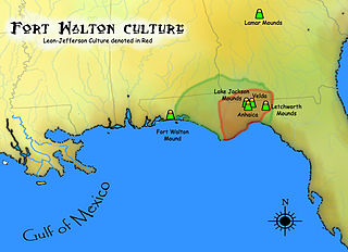
The Fort Walton culture is the term used by archaeologists for a late prehistoric Native American archaeological culture that flourished in southeastern North America from approximately 1200~1500 CE and is associated with the historic Apalachee people.

The Big Mound Key-Boggess Ridge Archeological District is a historic site near Placida, Florida. It is located southeast of Placida, on Big Mound Key. On December 3, 1990, it was added to the U.S. National Register of Historic Places.

The Jungle Prada Site is an archaeological site featuring Indigenous Tocobaga mounds and the location of the historical Narváez expedition landing. The Jungle Prada site spans public and private property, including the Jungle Prada de Narvaez city park, in St. Petersburg of Pinellas County, western coastal Florida, in the Southern United States.

The Weedon Island Preserve is a 3,190 acre natural area situated along the western shore of Tampa Bay, and located on 1800 Weedon Drive NE. St. Petersburg, Florida, United States. It is predominately an estuarine preserve composed of upland and aquatic ecosystems such as mangrove forests, pine/scrubby flatwoods, and maritime hammock, and is home to a variety of native wildlife. The preserve is also a designated archaeological area with several shell mounds identified on the property that provide evidence of early peoples who inhabited the land for thousands of years.

Charlotte Harbor Estuary, the second largest bay in Florida, is located on the Gulf of Mexico coast of west Florida, mostly (2/3) in Charlotte County, Florida with the remaining 1/3 in Lee County. The harbor's mouth is located behind Gasparilla Island, one of the many coastal barrier islands on the southwest coast of Florida, with access from the Gulf of Mexico through the Boca Grande Pass between Gasparilla Island on the north and Lacosta Island on the south. Charlotte Harbor covers about 270 sq mi (700 km2)
The Safety Harbor culture was an archaeological culture practiced by Native Americans living on the central Gulf coast of the Florida peninsula, from about 900 CE until after 1700. The Safety Harbor culture is defined by the presence of Safety Harbor ceramics in burial mounds. The culture is named after the Safety Harbor Site, which is close to the center of the culture area. The Safety Harbor Site is the probable location of the chief town of the Tocobaga, the best known of the groups practicing the Safety Harbor culture.

This is a timeline of the U.S. state of Florida.

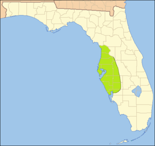
The Manasota culture was an archaeological culture that was practiced on the central Gulf coast of the Florida peninsula from about 500 BCE until about 900, when it developed into the Safety Harbor culture. From about 300 to 700 the Manasota culture adopted the ceremonial ceramics and burial practices of the Weeden Island cultures of northern Florida and adjacent Alabama and Georgia.

The Pensacola culture was a regional variation of the Mississippian culture along the Gulf Coast of the United States that lasted from 1100 to 1700 CE. The archaeological culture covers an area stretching from a transitional Pensacola/Fort Walton culture zone at Choctawhatchee Bay in Florida to the eastern side of the Mississippi River Delta near Biloxi, Mississippi, with the majority of its sites located along Mobile Bay in the Mobile-Tensaw River Delta. Sites for the culture stretched inland, north into the southern Tombigee and Alabama River valleys, as far as the vicinity of Selma, Alabama.

William Benton Henderson was a cattleman, merchant, and prominent figure in the history of Tampa, Florida. He is the namesake of Henderson Boulevard and Henderson Avenue as well as the former W. B. Henderson Elementary School.