Gandy, Florida | |
---|---|
former Census-designated place (CDP); Unincorporated community | |
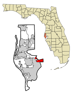
Location in Pinellas County and the state of Florida | |
Coordinates: 27°52′8″N82°37′29″W / 27.86889°N 82.62472°W Coordinates: 27°52′8″N82°37′29″W / 27.86889°N 82.62472°W | |
Country | |
State | |
County | Pinellas |
Area | |
• Total | 16.5 sq mi (42.9 km2) |
• Land | 2.5 sq mi (6.6 km2) |
• Water | 14 sq mi (36.3 km2) |
Elevation | -10 ft (-3 m) |
Population (2000) | |
• Total | 2,031 |
• Density | 123.1/sq mi (47.3/km2) |
Time zone | UTC-5 (Eastern (EST)) |
• Summer (DST) | UTC-4 (EDT) |
FIPS code | 12-25380 [1] |
GNIS feature ID | 1867143 [2] |
Gandy is an unincorporated community and former census-designated place (CDP) in Pinellas County, Florida, United States. [3] The population was 2,031 at the 2000 census. It is named after George Gandy and the Gandy Bridge which connects the area to Tampa across Old Tampa Bay.
Gandy is located at 27°52′8″N82°37′29″W / 27.86889°N 82.62472°W (27.868793, -82.624585). [4]
According to the United States Census Bureau, the CDP has a total area of 42.9 km² (16.5 mi²), of which 6.6 km² (2.5 mi²) is land and 36.3 km² (14.0 mi²) (84.65%) is water. It borders Weedon Island Preserve to the south and is the start of the Friendship Trail Bridge (old Gandy Bridge) linking Pinellas County and Hillsborough County.
Historical population | |||
---|---|---|---|
Census | Pop. | %± | |
1990 | 3,164 | — | |
2000 | 2,031 | −35.8% | |
source: [5] |
As of the census [1] of 2000, there were 2,031 people, 1,264 households, and 479 families residing in the CDP. The population density was 307.5/km² (797.1/mi²). There were 1,516 housing units at an average density of 229.5/km² (595.0/mi²). The racial makeup of the CDP was 91.43% White, 2.86% African American, 0.44% Native American, 2.36% Asian, 0.10% Pacific Islander, 0.59% from other races, and 2.22% from two or more races. Hispanic or Latino of any race were 3.79% of the population.
There were 1,264 households out of which 6.8% had children under the age of 18 living with them, 30.0% were married couples living together, 4.5% had a female householder with no husband present, and 62.1% were non-families. 52.1% of all households were made up of individuals and 18.9% had someone living alone who was 65 years of age or older. The average household size was 1.61 and the average family size was 2.26.
In the CDP, the population was spread out with 6.7% under the age of 18, 7.6% from 18 to 24, 29.9% from 25 to 44, 25.5% from 45 to 64, and 30.3% who were 65 years of age or older. The median age was 49 years. For every 100 females, there were 114.9 males. For every 100 females age 18 and over, there were 114.4 males.
The median income for a household in the CDP was $30,189, and the median income for a family was $39,417. Males had a median income of $31,364 versus $24,639 for females. The per capita income for the CDP was $23,660. About 4.5% of families and 5.2% of the population were below the poverty line, including none of those under age 18 and 12.0% of those age 65 or over.
Weeki Wachee Gardens is a census-designated place (CDP) in Hernando County, Florida, United States. The population was 1,146 at the 2010 census.
Keystone is an unincorporated census-designated place in Hillsborough County, Florida, United States. The population was 24,039 at the 2010 census, up from 14,627 at the 2000 census. The ZIP Codes encompassing the CDP area are 33556 and 33558.
Town 'n' Country is a census-designated place (CDP) in Hillsborough County, Florida, United States. The population was 78,442 at the 2010 census.
Lake Lucerne is a neighborhood in Miami Gardens, Florida, United States The population was 9,132 at the 2000 census.
High Point was a census-designated place (CDP) in Palm Beach County, Florida, United States. The population was 2,191 at the 2000 census. The CDP was removed from the 2010 census. Although it is still unincorporated, it is within Delray Beach's "future annexation area."
Bay Pines is a census-designated place (CDP) in Pinellas County, Florida, United States. The population was 2,931 at the 2010 census. The community is home to Bay Pines Veterans Hospital and Bay Pines National Cemetery.
East Lake is a census-designated place (CDP) in Pinellas County, Florida, United States. The population was 30,962 at the 2010 census. It was one of the last areas in the densely populated county to develop. It is often confused with East Lake in neighboring Hillsborough County.
Feather Sound is a census-designated place (CDP) in Pinellas County, Florida, United States. The population was 3,420 at the 2010 census. It includes the St. Petersburg-Clearwater International Airport.
Harbor Bluffs is a census-designated place (CDP) in Pinellas County, Florida, United States. The population was 2,860 at the 2010 census.
Ridgecrest is a census-designated place (CDP) in Pinellas County, Florida, United States. The population was 2,558 at the 2010 census.
South Highpoint is a census-designated place (CDP) in Pinellas County, Florida, United States. The population was 5,195 at the 2010 census.
West and East Lealman, more commonly known collectively as Lealman, was a census-designated place (CDP) in Pinellas County, Florida, United States. The population was 21,753 at the 2000 census. For the 2010 census, the area was split into two separate CDPs, Lealman and West Lealman.
Delano is a census-designated place (CDP) in Schuylkill County, Pennsylvania, United States. The population was 377 at the 2000 census.
Antreville is a census-designated place (CDP) in Abbeville County, South Carolina, United States. The population was 140 at the 2010 census.
Modoc is a census-designated place (CDP) in McCormick County, South Carolina, United States. The population was 256 at the 2000 census, and 218 at the 2010 census, a decline of 14.8%.
Atkins is a census-designated place (CDP) in Smyth County, Virginia, United States. The population was 1,143 at the 2010 census.
North Marysville is a census-designated place (CDP) in Snohomish County, Washington, United States. The majority of the community and its 20,000 residents were annexed into the city of Marysville in 2009. The population was 108 at the 2010 census.
Lynnwood-Pricedale is a census-designated place (CDP) in Fayette and Westmoreland counties in the commonwealth of Pennsylvania, United States. The population was 2,031 at the 2010 census, down from 2,168 at the 2000 census. The community of Lynwood is located in Fayette County's Washington Township, while Pricedale is part of Westmoreland County's Rostraver Township.
Oxford is a census-designated place (CDP) in the town of Oxford in Worcester County, Massachusetts, United States. The population was 6,103 at the 2010 census.
Nantucket is a census designated place (CDP) in the town of Nantucket in Nantucket County, Massachusetts, United States. The population was 3,830 at the 2000 census.