Harbor Bluffs, Florida

Last updated
Harbor Bluffs, Florida
Pinellas County Florida Incorporated and Unincorporated areas Harbor Bluffs Highlighted.svg
Location in Pinellas County and the state of Florida
Coordinates: 27°54′28″N82°49′30″W / 27.90778°N 82.82500°W / 27.90778; -82.82500 Coordinates: 27°54′28″N82°49′30″W / 27.90778°N 82.82500°W / 27.90778; -82.82500
Country Flag of the United States.svg  United States
State Flag of Florida.svg  Florida
County   Pinellas
Area
[1]
  Total0.95 sq mi (2.47 km2)
  Land0.69 sq mi (1.79 km2)
  Water0.26 sq mi (0.67 km2)
Elevation
10 ft (3 m)
Population
 (2020)
  Total2,646
  Density3,818.18/sq mi (1,475.20/km2)
Time zone UTC-5 (Eastern (EST))
  Summer (DST) UTC-4 (EDT)
ZIP code
33770 [2]
Area code 727
FIPS code 12-28650 [3]
GNIS feature ID1867150 [4]

Harbor Bluffs is a census-designated place (CDP) in Pinellas County, Florida, United States. The population was 2,860 at the 2010 census. [5]

Contents

Geography

Harbor Bluffs is located at 27°54′28″N82°49′30″W / 27.90778°N 82.82500°W / 27.90778; -82.82500 (27.907699, -82.825074). [6]

According to the United States Census Bureau, the CDP has a total area of 2.5 km2 (0.9 mi2), of which 1.8 km2 (0.7 mi2) is land and 0.7 km2 (0.3 mi2) (27.37%) is water.

Demographics

Historical population
CensusPop.Note
1990 2,659
2000 2,8075.6%
2010 2,8601.9%
2020 2,646−7.5%
source: [5] [7]

As of the census [3] of 2000, there were 2,807 people, 1,186 households, and 876 families residing in the CDP. The population density was 1,548.3/km2 (4,030.3/mi2). There were 1,251 housing units at an average density of 690.0/km2 (1,796.2/mi2). The racial makeup of the CDP was 97.04% White, 0.11% African American, 0.04% Native American, 1.57% Asian, 0.25% from other races, and 1.00% from two or more races. Hispanic or Latino of any race were 1.96% of the population.

There were 1,186 households, out of which 25.7% had children under the age of 18 living with them, 66.4% were married couples living together, 5.6% had a female householder with no husband present, and 26.1% were non-families. 21.8% of all households were made up of individuals, and 13.2% had someone living alone who was 65 years of age or older. The average household size was 2.36 and the average family size was 2.76.

In the CDP, the population was spread out, with 19.3% under the age of 18, 3.6% from 18 to 24, 22.8% from 25 to 44, 30.7% from 45 to 64, and 23.6% who were 65 years of age or older. The median age was 47 years. For every 100 females, there were 93.1 males. For every 100 females age 18 and over, there were 91.1 males.

The median income for a household in the CDP was $61,397, and the median income for a family was $68,000. Males had a median income of $49,943 versus $30,900 for females. The per capita income for the CDP was $39,261. About 3.9% of families and 5.7% of the population were below the poverty line, including 8.9% of those under age 18 and 8.4% of those age 65 or over.

Related Research Articles

<span class="mw-page-title-main">Charlotte Park, Florida</span> Census-designated place in Florida, United States

Charlotte Park is a census-designated place (CDP) in Charlotte County, Florida, United States. The population was 2,667 at the 2020 census. It is part of the Sarasota-Bradenton-Punta Gorda Combined Statistical Area.

<span class="mw-page-title-main">Bay Pines, Florida</span> Census-designated place in Florida, United States

Bay Pines is a census-designated place (CDP) in Pinellas County, Florida, United States. The population was 2,931 at the 2010 census. The community is home to Bay Pines Veterans Hospital and Bay Pines National Cemetery.

<span class="mw-page-title-main">Feather Sound, Florida</span> Census-designated place in Florida, United States

Feather Sound is a census-designated place (CDP) in Pinellas County, Florida, United States. The population was 3,420 at the 2010 census. It includes the St. Petersburg-Clearwater International Airport.

<span class="mw-page-title-main">Gandy, Florida</span> Place in Florida, United States

Gandy is an unincorporated community and former census-designated place (CDP) in Pinellas County, Florida, United States. The population was 2,031 at the 2000 census. It is named after George Gandy and the Gandy Bridge which connects the area to Tampa across Old Tampa Bay.

<span class="mw-page-title-main">Ridgecrest, Florida</span> Census-designated place in Florida, United States

Ridgecrest is a census-designated place (CDP) in Pinellas County, Florida, United States. The population was 2,558 at the 2010 census.

<span class="mw-page-title-main">South Highpoint, Florida</span> Census-designated place in Florida, United States

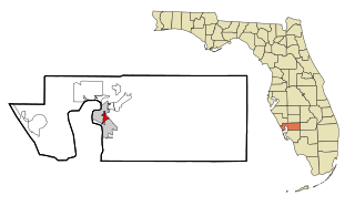
South Highpoint is a census-designated place (CDP) in Pinellas County, Florida, United States. The population was 5,195 at the 2010 census.

<span class="mw-page-title-main">West Concord, Massachusetts</span> CDP in Massachusetts, United States

West Concord is an unincorporated village and census-designated place (CDP) in the town of Concord in Middlesex County, Massachusetts, United States. The population was 6,028 at the 2010 census.

<span class="mw-page-title-main">Marshfield Hills, Massachusetts</span> Census-designated place in Massachusetts, United States

Marshfield Hills is a census-designated place (CDP) in the town of Marshfield in Plymouth County, Massachusetts, United States. The population was 2,356 at the 2010 census. The historic center of the village has been designated a historic district and listed on the National Register of Historic Places.

<span class="mw-page-title-main">Ocean Bluff-Brant Rock, Massachusetts</span> Census-designated place in Massachusetts, United States

Ocean Bluff-Brant Rock is a census-designated place (CDP) in Plymouth County, Massachusetts, United States, composed of the neighborhoods of Ocean Bluff, Brant Rock, Fieldston, and Rexhame in the town of Marshfield. The population of the CDP was 4,970 at the 2010 census.

<span class="mw-page-title-main">Isleta Village Proper, New Mexico</span> Census-designated place in New Mexico, United States

Isleta Village Proper is a census-designated place (CDP) in Bernalillo County, New Mexico, United States. The population was 491 at the 2010 census. It is part of the Albuquerque Metropolitan Statistical Area.

<span class="mw-page-title-main">Rio en Medio, New Mexico</span> CDP in New Mexico, United States

Rio en Medio is a census-designated place (CDP) in Santa Fe County, New Mexico, United States. It is part of the Santa Fe, New Mexico Metropolitan Statistical Area. The population was 131 at the 2000 census.

Tagg Flats is a census-designated place (CDP) in Delaware County, Oklahoma, United States. The population was 13 at the 2010 census.

<span class="mw-page-title-main">Oak Hills, Pennsylvania</span> Census-designated place in Pennsylvania, United States

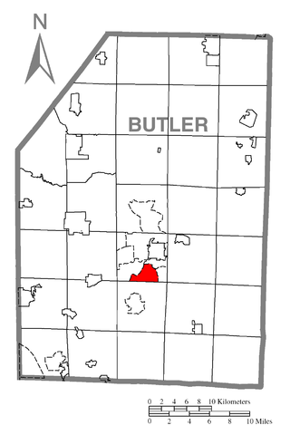
Oak Hills is a census-designated place (CDP) in Butler County, Pennsylvania, United States. The population was 2,333 at the 2010 census.

<span class="mw-page-title-main">Nuremberg, Pennsylvania</span> Census-designated place in Pennsylvania, United States

Nuremberg is a census-designated place (CDP) in Schuylkill and Luzerne counties, Pennsylvania, United States. The population was 434 at the 2010 census.

<span class="mw-page-title-main">Bluetown-Iglesia Antigua, Texas</span> Former CDP in Texas, United States

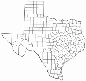
Bluetown-Iglesia Antigua was a census-designated place (CDP) in Cameron County, Texas, United States. The population was 692 at the 2000 census. For the 2010 census the area was split into two CDPs, Bluetown and Iglesia Antigua. The communities are part of the Brownsville–Harlingen Metropolitan Statistical Area.

<span class="mw-page-title-main">La Feria, Texas</span> City in Texas, United States

La Feria is a city in Cameron County, Texas, United States. Its population was 7,302 at the time of the 2010 census. It is part of the Brownsville–Harlingen–Raymondville, the Matamoros–Brownsville, and the McAllen–Edinburg–Mission metropolitan areas.

Little Cottonwood Creek Valley was a census-designated place (CDP) in Salt Lake County, Utah. The 2000 Census population was 7,221, an increase over the 1990 figure of 5,042. In 2005, the CDP became part of the newly incorporated city of Cottonwood Heights.

<span class="mw-page-title-main">Keokee, Virginia</span> Census-designated place in Virginia, United States

Keokee is an unincorporated community and census-designated place (CDP) in Lee County, Virginia, United States. The population was 416 at the 2010 census.

<span class="mw-page-title-main">Chehalis Village, Washington</span> Former CDP in Washington, United States

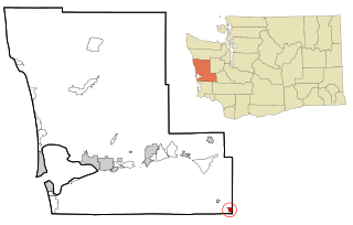
Chehalis Village is a former census-designated place (CDP) in Grays Harbor County, Washington, United States. The population was 346 at the 2000 census. The area was no longer listed as a CDP for the 2010 census.

<span class="mw-page-title-main">Boothbay Harbor (CDP), Maine</span> Census-designated place in Maine, United States

Boothbay Harbor is a census-designated place (CDP) comprising the densely populated center of the town of Boothbay Harbor in Lincoln County, Maine, United States. The population was 1,086 at the 2010 census, down from 1,237 at the 2000 census.

References

  1. "2020 U.S. Gazetteer Files". United States Census Bureau. Retrieved October 31, 2021.
  2. "Harbor Bluffs FL ZIP Code". zipdatamaps.com. 2023. Retrieved February 17, 2023.
  3. 1 2 "U.S. Census website". United States Census Bureau . Retrieved 2008-01-31.
  4. "US Board on Geographic Names". United States Geological Survey. 2007-10-25. Retrieved 2008-01-31.
  5. 1 2 "Profile of General Population and Housing Characteristics: 2010 Demographic Profile Data (DP-1): Harbor Bluffs CDP, Florida". United States Census Bureau . Retrieved May 15, 2012.
  6. "US Gazetteer files: 2010, 2000, and 1990". United States Census Bureau. 2011-02-12. Retrieved 2011-04-23.
  7. "CENSUS OF POPULATION AND HOUSING (1790-2000)". U.S. Census Bureau . Retrieved 2010-07-17.