
Coquina is a sedimentary rock that is composed either wholly or almost entirely of the transported, abraded, and mechanically sorted fragments of mollusks, trilobites, brachiopods, or other invertebrates. The term coquina comes from the Spanish word for "cockle" and "shellfish".
Nanjemoy is a settlement along Maryland Route 6 in southwestern Charles County, Maryland, United States, and the surrounding large rural area more or less bounded by Nanjemoy Creek to the east and north, and the Potomac River to the south and west.

The Flint Hills, historically known as Bluestem Pastures or Blue Stem Hills, are a region of hills and prairies that lie mostly in eastern Kansas. It is named for the abundant residual flint eroded from the bedrock that lies near or at the surface. It consists of a band of hills extending from Marshall and Washington Counties in the north to Cowley County, Kansas and Kay and Osage Counties in Oklahoma in the south, to Geary and Shawnee Counties west to east. Oklahomans generally refer to the same geologic formation as the Osage Hills or "the Osage."

Serpentine soil is an uncommon soil type produced by weathered ultramafic rock such as peridotite and its metamorphic derivatives such as serpentinite. More precisely, serpentine soil contains minerals of the serpentine subgroup, especially antigorite, lizardite, and chrysotile or white asbestos, all of which are commonly found in ultramafic rocks. The term "serpentine" is commonly used to refer to both the soil type and the mineral group which forms its parent materials.

John Boyd Thacher State Park is a state park located 15 miles (24 km) southwest of Albany, New York, near Voorheesville, in Albany County on State Route 157. Located mostly atop the Helderberg Escarpment, the park has several hiking trails that offer panoramic views of the Green Mountains in Vermont and the Taconic Mountains of the Hudson Valley.

Big Talbot Island State Park is a state park in Florida, United States. It is located on Big Talbot Island, a coastal barrier island 20 miles east of downtown Jacksonville on A1A North and immediately north of Little Talbot Island State Park along the Atlantic coastal plain.

The Big Morongo Canyon Preserve is a 31,000-acres (130 km2) native plants habitat and wildlife preserve located in the Little San Bernardino Mountains of the Transverse Ranges, in the transition zone between the higher Mojave Desert and lower elevation Colorado Desert section of the Sonoran Desert. Due to its location within this transition zone, the area is especially high in natural diversity. The natural spring fed desert oasis found here is one of the 10 largest Cottonwood and Willow riparian habitats in California. It is also identified by the Audubon Society as one of the most important avian habitat areas in California.

The Jug Bay Wetlands Sanctuary is located along the tidal Patuxent River in southern Maryland, United States. It was established in 1985 and is operated by the Anne Arundel County Department of Recreation and Parks. It includes more than 1,700 acres (6.9 km2) of tidal freshwater wetlands, forests, meadows and fields. The wetlands, with large stands of aquatic plants including wild rice, are home to many birds, fish, reptiles, amphibians, and mammals. Miles of trails and boardwalks traverse a variety of habitats and provide glimpses into the rich history of the region. Notably, archaeologists have uncovered evidence of a large Native American settlement at Jug Bay which spanned 2 miles along the Patuxent, with the oldest arrowhead-like artifact dated between 8,000 to 8,900 years old.

Sandy Island Beach State Park is a New York State park on the eastern shore of Lake Ontario. Its highlight is a 1,500-foot (460 m) natural sandy beach. The park is near the southern end of a notable 17-mile (27 km) length of sandy shoreline, coastal dunes, and wetlands ; a 1959 study noted that "The eastern end of Lake Ontario contains not only the finest beaches on the entire lake but also the finest wildlife habitat."
Lettuce Lake Park is a 240-acre (97 ha) Hillsborough County-run park just outside the city limits of Tampa, Florida. It is located on Fletcher Avenue between Interstate 75 and the University of South Florida. The Hillsborough River runs through it. The park opened in 1982.

The Fairfield Osborn Preserve is a 450-acre nature reserve situated on the northwest flank of Sonoma Mountain in Sonoma County, California. There are eight plant communities within the property, oak woodland being the dominant type. Other communities include chaparral, Douglas fir woodland, native Bunch grass, freshwater marsh, vernal pool, pond and riparian woodland. The flora is extremely diverse including many native trees, shrubs, wildflowers, grasses, lichens and mosses. A diverse fauna inhabits this area including black-tailed deer, coyote, bobcat and an occasional mountain lion; moreover, there are abundant avifauna, amphibians, reptiles and insects.

Green Cay Wetlands is a nature preserve located in Boynton Beach, Florida. The 100-acre (0.40 km2) property was purchased in 1999 from Ted and Trudy Winsberg, who used the property for farming. The Winsbergs sold the property for 1/3 of its appraised value with the condition that it would be made into a wetland. Construction began in July 2003. It was created jointly by the Palm Beach County Utilities Department and the Palm Beach County Parks and Recreation Department in 2004. This park includes 1.5 miles (2.4 km) of an elevated wooden boardwalk, which takes visitors through various habitats, including cabbage palm hammock, cypress swamp, wetland hammock, and tropical hardwood hammock. The boardwalk also features a Seminole chickee hut as well as several gazebos, which have descriptive signs offering information on the wildlife and plant life.
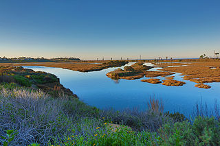
San Elijo Lagoon Ecological Reserve is one of the largest remaining coastal wetlands in San Diego County, California, United States.
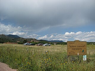
Aiken Canyon Preserve is a 1,621-acre (6.56 km2) Nature Conservancy-managed state property in Colorado. It was first observed and named after Charles Aiken, a 19th-century U.S. surveyor, pioneer, and ornithologist who first surveyed the region in the 1870s and identified more than 75 bird species. The preserve consists of foothills, shrub and woodland ecosystems and is 12.4 miles (20.0 km) southeast from Colorado Springs located on the eastern slope of the Rampart Range which is within a smaller foothill system of the Front Range. The surrounding mountain ranges of the Rampart Range and Palmer Divide created the nature preserves sustainable ecosystem. There is also a four-mile (6 km)-loop hiking trail on the preserve.
The Anastasia Formation is a geologic formation deposited in Florida during the Late Pleistocene epoch.

The Palos Verdes Peninsula Land Conservancy (PVPLC) is a non-profit organization that is based on the Palos Verdes Peninsula in southwestern Los Angeles County, California.
The Eshqua Bog Natural Area is a protected area in Hartland, Vermont. It is 41 acres containing a wet bog. It is near Woodstock, about 11 miles west of White River Junction. There is a boardwalk allowing access to the wetland and views of rare plants.

The Tree Hill Nature Center is a 501(c)(3) non-profit organization and wilderness preserve in Jacksonville, Florida, organized for the purpose of providing an educational experience for visitors to appreciate and learn about the natural environment in Jacksonville. The land was acquired to preserve and protect an urban wilderness area containing sensitive plants and animals from surrounding development. The city park opened in 1971.
The Conservancy of Southwest Florida is an organization located on 21 acres in Naples, Florida, and features the Conservancy of Southwest Florida Nature Center.


