Layton, Florida

Last updated

Layton, Florida
Downtown Layton Florida.jpg
Downtown Layton as seen from US 1 looking south along the road
Layton seal.gif
Monroe County Florida Incorporated and Unincorporated areas Layton Highlighted.svg
Location in Monroe County and the state of Florida
Layton.gif
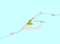
U.S. Census Bureau map showing city limits
Coordinates: 24°49′36″N80°48′50″W / 24.82667°N 80.81389°W / 24.82667; -80.81389
Country Flag of the United States.svg  United States
State Flag of Florida.svg  Florida
County Flag of Monroe County, Florida.png Monroe
Settled
(Long Key Settlement)
Late 19th century–1910
Incorporated
(City of Layton)
September 18, 1963 [1]
Government
  Type Mayor-Council
   Mayor Bruce Halle
   Vice Mayor Gregory Lewis
   Councilors Yesenia Diaz,
Philip Porter,
Cindy Lewis, and
Susan Grant
   City Clerk Mimi M. Young
Area
[2]
  Total0.22 sq mi (0.58 km2)
  Land0.16 sq mi (0.42 km2)
  Water0.06 sq mi (0.16 km2)
Elevation
3 ft (0.9 m)
Population
 (2020) [3]
  Total210
  Density1,296.30/sq mi (499.47/km2)
Time zone UTC-5 (Eastern (EST))
  Summer (DST) UTC-4 (EDT)
ZIP code
33001
Area code 305
FIPS code 12-39725 [4]
GNIS feature ID0285408 [5]
Website www.cityoflayton.com

Layton is a city located on the island of Long Key in Monroe County, Florida, United States. The city is part of the Florida Keys. The population was 210 at the 2020 census. [3]

Contents

History

In the late 19th century, Long Key was used as a coconut plantation. By 1910, Layton was becoming famous as a fishing destination, thanks in part to promotion by sportswriter, Zane Grey. However, the developing tourist infrastructure on Long Key, including a station on the Overseas Railroad, was largely destroyed by the Labor Day Hurricane of 1935.

After World War II, Mary and Del Layton (born 1906), who ran a grocery business in Miami, bought 40 acres (160,000 m2) on Long Key and started developing the property as "Layton's Long Key Fishing Camp", which grew substantially over the succeeding years.

Layton was incorporated as a city on September 18, 1963. [1] The land that would become Long Key State Park was acquired between 1961 and 1973; the park opened on October 1, 1969.

Geography

The approximate coordinates for the City of Layton is located along U.S. Route 1 at 24°49′36″N80°48′50″W / 24.826669°N 80.814006°W / 24.826669; -80.814006 . [6] Via US 1 it is 66 miles (106 km) northeast of Key West and 88 miles (142 km) southwest of Miami.

According to the United States Census Bureau, the city has a total area of 0.22 square miles (0.57 km2). 0.16 square miles (0.41 km2) of it are land and 0.06 square miles (0.16 km2) of it (27.03%) are water. [2]

Climate

The City of Layton has a tropical savanna climate (the Köppen climate classification is known as "Aw"), similar to the Caribbean islands).

Demographics

Historical population
CensusPop.Note
1970 100
1980 88−12.0%
1990 183108.0%
2000 1861.6%
2010 184−1.1%
2020 21014.1%
U.S. Decennial Census [7]

2010 and 2020 census

Layton racial composition
(Hispanics excluded from racial categories)
(NH = Non-Hispanic)
RacePop 2010 [8] Pop 2020 [9] % 2010% 2020
White (NH)15816585.87%78.57%
Black or African American (NH)422.17%0.95%
Native American or Alaska Native (NH)301.63%0.00%
Asian (NH)402.17%0.00%
Pacific Islander or Native Hawaiian (NH)000.00%0.00%
Some other race (NH)000.00%0.00%
Two or more races/Multiracial (NH)221.09%0.95%
Hispanic or Latino (any race)13417.07%19.52%
Total184210

As of the 2020 United States census, there were 210 people, 55 households, and 28 families residing in the city. [10]

As of the 2010 United States census, there were 184 people, 76 households, and 47 families residing in the city. [11]

2000 census

As of the census [4] of 2000, there were 186 people, 84 households, and 50 families living in the city. The population density was 860.0 inhabitants per square mile (332.0/km2). There were 165 housing units at an average density of 762.9 per square mile (294.6/km2). The racial makeup of the city was 98.92% White, 0.54% African American and 0.54% Asian. Hispanic or Latino of any race were 2.15% of the population.

In 2000, there were 84 households, out of which 15.5% had children under the age of 18 living with them, 56.0% were married couples living together, 1.2% had a female householder with no husband present, and 39.3% were non-families. 22.6% of all households were made up of individuals, and 4.8% had someone living alone who was 65 years of age or older. The average household size was 2.21 and the average family size was 2.61.

A sign indicating the border of the city of Layton Layton Florida sign.jpg
A sign indicating the border of the city of Layton

In 2000, in the city, the population was spread out, with 11.3% under the age of 18, 7.5% from 18 to 24, 23.1% from 25 to 44, 39.8% from 45 to 64, and 18.3% who were 65 years of age or older. The median age was 51 years. For every 100 females, there were 95.8 males. For every 100 females age 18 and over, there were 98.8 males.

In 2000, the median income for a household in the city was $53,750, and the median income for a family was $73,750. Males had a median income of $29,896 versus $23,125 for females. The per capita income for the city was $23,773. About 11.7% of families and 15.4% of the population were below the poverty line, including none of those under the age of eighteen and 21.4% of those 65 or over.

Languages

As of 2000, English as a first language accounted for 90.68%, while Spanish as a mother tongue made up 9.31% of the population. [12]

Education

All public schools are served by the Monroe County School District. Students are zoned to Plantation Key School (K-8). [13]

Related Research Articles

Parker is a city in Bay County, Florida, United States. It is part of the Panama City–Lynn Haven–Panama City Beach Metropolitan Statistical Area. As of the 2020 US census, it had a population of 4,010.

<span class="mw-page-title-main">Bowling Green, Florida</span> City in Florida, United States

Bowling Green is a city in Hardee County, Florida, United States. The population was 2,405 at the 2020 census.

<span class="mw-page-title-main">Cottondale, Florida</span> City in Florida, United States

Cottondale is a city in Jackson County, Florida, United States. It is part of the Florida Panhandle and North Florida. The population was 848 at the 2020 census, down from 933 at the 2010 census.

<span class="mw-page-title-main">Sneads, Florida</span> Town in the state of Florida, United States

Sneads is a town in Jackson County, Florida, United States. The population was 1,849 at the 2020 census.

<span class="mw-page-title-main">Mascotte, Florida</span> City in Florida

Mascotte is a city in Lake County, Florida, United States. As of the 2020 census, the population was 6,609, up from 5,101 in 2010. It is part of the Orlando–Kissimmee–Sanford Metropolitan Statistical Area.

<span class="mw-page-title-main">Bronson, Florida</span> Town in Florida, United States

Bronson is a town and the county seat of Levy County, Florida, United States. The population was 1,140 at the 2020 census.

<span class="mw-page-title-main">Inglis, Florida</span> Town in Florida, United States

Inglis is a town in Levy County, Florida, United States. It is on U.S. Highway 19 near the Cross Florida Greenway. As of the 2020 census, the town had a population of 1,476.

<span class="mw-page-title-main">Belleview, Florida</span> City in Florida, United States

Belleview is a city in Marion County, Florida, United States. The population was 5,413 at the 2020 census, up from 4,492 in 2010. It is part of the Ocala Metropolitan Statistical Area. The city's name comes from the French words belle and vue, meaning "beautiful view". "City with Small Town Charm" is the city's motto.

<span class="mw-page-title-main">Coral Terrace, Florida</span> Census-designated place in Florida

Coral Terrace is a suburban unincorporated community and census-designated place (CDP) in Miami-Dade County, Florida, United States. It is part of the Miami metropolitan area of South Florida. The population was 23,142 at the 2020 census, down from 24,376 in 2010.

<span class="mw-page-title-main">Pinewood, Florida</span> Census-designated place in Florida

Pinewood is an unincorporated community and census-designated place (CDP) in Miami-Dade County, Florida, United States. It is part of the Miami metropolitan area of South Florida. The population was 17,246 at the 2020 census.

<span class="mw-page-title-main">Three Lakes, Florida</span> Census-designated place in Florida

Three Lakes is a census-designated place (CDP) and planned community in Miami-Dade County, Florida, United States. It is part of the Miami metropolitan area of South Florida. The population was 16,540 at the 2020 census, up from 15,047 in 2010.

<span class="mw-page-title-main">Westview, Florida</span> Census-designated place in Florida

Westview is a census-designated place (CDP) in Miami-Dade County, Florida, United States. It is part of the Miami metropolitan area of South Florida. The population was 9,923 at the 2020 census.

<span class="mw-page-title-main">Niceville, Florida</span> City in Florida, United States

Niceville is a city in Okaloosa County, Florida, United States, located near Eglin Air Force Base on Boggy Bayou that opens into Choctawhatchee Bay. It is part of the Fort Walton Beach–Crestview–Destin Metropolitan Statistical Area. The population was 15,772 at the 2020 census.

<span class="mw-page-title-main">North Redington Beach, Florida</span> Town in the state of Florida, United States

North Redington Beach is a town in Pinellas County, Florida, United States. It is part of the Tampa–St. Petersburg–Clearwater Metropolitan Statistical Area, more commonly known as the Tampa Bay Area. The population was 1,495 at the 2020 census.

<span class="mw-page-title-main">Highland Park, Florida</span> Village in Florida, United States

Highland Park is a village in Polk County, Florida, United States. Highland Park is part of the Lakeland–Winter Haven Metropolitan Statistical Area. Its population was 251 at the 2020 US census.

<span class="mw-page-title-main">Pomona Park, Florida</span> Town in the state of Florida, United States

Pomona Park is a town in Putnam County, Florida, United States. The Town of Pomona Park is part of the Palatka Micropolitan Statistical Area. The population was 784 at the 2020 census.

<span class="mw-page-title-main">St. Lucie Village, Florida</span> Town in the state of Florida, United States

St. Lucie Village is a town in St. Lucie County, Florida, United States. It is part of the Port St. Lucie Metropolitan Statistical Area. The population was 613 at the 2020 census.

<span class="mw-page-title-main">Webster, Florida</span> City in Florida, United States

Webster is a city located in Sumter County, Florida, United States. As of the 2020 census, the city had a total population of 778.

<span class="mw-page-title-main">Lake Helen, Florida</span> City in Florida, United States

Lake Helen is a city in Volusia County, Florida, United States. It is part of the Deltona–Daytona Beach–Ormond Beach, Florida Metropolitan Statistical Area. The population was 2,842 at the 2020 census.

<span class="mw-page-title-main">South Miami Heights, Florida</span> Census-designated place in Florida

South Miami Heights is a census-designated place (CDP), originally known as Eureka, in Miami-Dade County, Florida. It is part of the Miami metropolitan area of South Florida. The population was 36,770 as of the 2020 census.

References

  1. 1 2 "FLORIDA CITIES BY INCORPORATION YEAR WITH INCORPORATION & DISSOLUTION INFO" (PDF). United States Census Bureau .
  2. 1 2 "2022 U.S. Gazetteer Files: Florida". United States Census Bureau. Retrieved January 18, 2023.
  3. 1 2 "P1. Race – Layton city, Florida: 2020 DEC Redistricting Data (PL 94-171)". U.S. Census Bureau. Retrieved January 18, 2023.
  4. 1 2 "U.S. Census website". United States Census Bureau . Retrieved January 31, 2008.
  5. "US Board on Geographic Names". United States Geological Survey. October 25, 2007. Retrieved January 31, 2008.
  6. "US Gazetteer files: 2010, 2000, and 1990". United States Census Bureau. February 12, 2011. Retrieved April 23, 2011.
  7. "Census of Population and Housing". Census.gov. Retrieved June 4, 2015.
  8. "P2 HISPANIC OR LATINO, AND NOT HISPANIC OR LATINO BY RACE - 2010: DEC Redistricting Data (PL 94-171) - Layton city, Florida". United States Census Bureau .
  9. "P2 HISPANIC OR LATINO, AND NOT HISPANIC OR LATINO BY RACE - 2020: DEC Redistricting Data (PL 94-171) - Layton city, Florida". United States Census Bureau .
  10. "S1101 HOUSEHOLDS AND FAMILIES - 2020: Layton city, Florida". United States Census Bureau .
  11. "S1101 HOUSEHOLDS AND FAMILIES - 2010: Layton city, Florida". United States Census Bureau .
  12. Modern Language Association Data Center Results of Layton, Florida
  13. "Elementary Schools: Boca Chica to Ocean Reef/County Line". Monroe County School District . Retrieved August 1, 2022. - Linked from