
Monroe County is the southernmost county of the state of Florida. As of the 2020 census, the population was 82,874. Its county seat is Key West. Monroe County includes the islands of the Florida Keys and comprises the Key West-Key Largo Micropolitan Statistical Area. Over 99.9% of the county's population lives on the Florida Keys. The mainland, which is part of the Everglades, comprises 87% of the county's land area and is virtually uninhabited with only 17 people recorded in the 2020 census.

The Everglades is a natural region of flooded grasslands in the southern portion of the U.S. state of Florida, comprising the southern half of a large drainage basin within the Neotropical realm. The system begins near Orlando with the Kissimmee River, which discharges into the vast but shallow Lake Okeechobee. Water leaving the lake in the wet season forms a slow-moving river 60 miles (97 km) wide and over 100 miles (160 km) long, flowing southward across a limestone shelf to Florida Bay at the southern end of the state. The Everglades experiences a wide range of weather patterns, from frequent flooding in the wet season to drought in the dry season. Throughout the 20th century, the Everglades suffered significant loss of habitat and environmental degradation.

Everglades City is a city in Collier County, Florida, United States, of which it was once the county seat. It is part of the Naples–Marco Island Metropolitan Statistical Area, which is included in the Cape Coral-Fort Myers-Naples Combined Statistical Area. The Gulf Coast Visitor Center for Everglades National Park is located in Everglades City. As of the 2020 US census, the population was 352, down from 400 in the 2010 US census.
Florida City is a city in Miami-Dade County, Florida, United States. It is the southernmost municipality in the South Florida metropolitan area. Florida City is primarily a Miami suburb and a major agricultural area. As of the 2020 census, it had a population of 13,085, up from 11,245 in 2010.

Flamingo is the southernmost headquarters of Everglades National Park, in Monroe County, Florida, United States. Flamingo is one of the two end points of the 99-mile (159-km) Wilderness Waterway, and the southern end of the only road through the park from Florida City. It began as a small coastal settlement on the eastern end of Cape Sable on the southern tip of the Florida peninsula, facing Florida Bay. The actual town of Flamingo was located approximately 4+1⁄2 miles west of the current Flamingo campground area. All that remains of the former town are a few remnants of building foundations, and it is considered a ghost town.

Everglades National Park is a national park of the United States that protects the southern twenty percent of the original Everglades in Florida. The park is the largest tropical wilderness in the United States and the largest wilderness of any kind east of the Mississippi River. An average of one million people visit the park each year. Everglades is the third-largest national park in the contiguous United States after Death Valley and Yellowstone. UNESCO declared the Everglades & Dry Tortugas Biosphere Reserve in 1976 and listed the park as a World Heritage Site in 1979, and the Ramsar Convention included the park on its list of Wetlands of International Importance in 1987. Everglades is one of only three locations in the world to appear on all three lists.
The Tamiami Trail is the southernmost 284 miles (457 km) of U.S. Highway 41 (US 41) from State Road 60 (SR 60) in Tampa to US 1 in Miami. A portion of the road also has the hidden designation of State Road 90 (SR 90).

The Florida East Coast Railway is a Class II railroad operating in the U.S. state of Florida, currently owned by Grupo México.

State Road 9336, also known in parts as the Ingraham Highway, Tower Road and West Palm Drive, is an 8.75-mile-long (14.08 km) two- to four-lane road in Miami-Dade County, in the U.S. state of Florida. The route is the only signed four-digit state road in Florida. The route connects US 1, and the Homestead Extension of Florida's Turnpike by proxy, in Florida City with the Everglades National Park, acting as the park's primary mode of entry. The road continues on from its western terminus at the national park's entrance as Main Park Road for another 39.3 miles (63.2 km), providing access to many of the park's facilities and the ghost town of Flamingo, in Monroe County, at its western end.

Barron Gift Collier was an American advertising entrepreneur who became the largest landowner and developer in the U.S. state of Florida, as well as the owner of a chain of hotels, bus lines, several banks, newspapers, a telephone company and a steamship line.
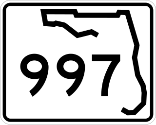
State Road 997, also known as Krome Avenue and West 177th Avenue is a 36.7-mile-long (59.1 km) north–south state highway in western Miami-Dade County, Florida. It runs from State Road 998 in Homestead north across U.S. Route 41 to U.S. Route 27 near Countyline Dragway, just south of the Broward County line. Its main use is as a bypass around the western side of Miami, linking the routes that run southwest, west and northwest from that city. The road passes through newer suburbs in the southern third of its length, while the northern two thirds of the highway traverse the eastern edge of the Everglades.
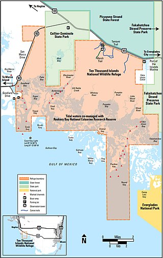
The Ten Thousand Islands are a chain of islands and mangrove islets off the coast of southwest Florida, between Cape Romano and the mouth of the Lostmans River. Some of the islands are high spots on a submergent coastline. Others were produced by mangroves growing on oyster bars. Despite the name, the islets in the chain only number in the hundreds.

Carnestown is an uninhabited unincorporated area in Collier County, Florida, United States, located at the intersection of United States Route 41 and State Road 29. The area is named for Juliet Gordon Carnes (1884-1971), whom Barron Collier, the county's namesake, married in 1907.

Old Cutler Road is an off-grid plan, 14.9-mile (24.0 km) main northeast–southwest road running south of downtown Miami in Miami-Dade County, Florida, United States.

Shark Valley is a geological depression at the head of the Shark River Slough in far western Miami-Dade County, Florida, United States. It is currently part of Everglades National Park. Shark Valley empties into Shark River in the Ten Thousand Islands of Monroe County. Shark Valley characteristically includes sawgrass prairie that floods during the rainy season, hence the name "river of grass"—Pa-Hay-Okee, from the Mikasuki language—for such marshes in the Everglades. Shark Valley features a Visitor Center with educational displays, a park video, an underwater camera and informational brochures. The entrance to Shark Valley is located along Tamiami Trail near the Miami-Dade–Collier County line.

A national push for expansion and progress toward the latter part of the 19th century stimulated interest in draining the Everglades, a region of tropical wetlands in southern Florida, for agricultural use. According to historians, "From the middle of the nineteenth century to the middle of the twentieth century, the United States went through a period in which wetland removal was not questioned. Indeed, it was considered the proper thing to do."

The Seaboard–All Florida Railway was a subsidiary of the Seaboard Air Line Railroad that oversaw two major extensions of the system in the early 1920s to southern Florida on each coast during the land boom. One line extended the Seaboard's tracks on the east coast from West Palm Beach down to Fort Lauderdale and Miami, while the other extension on the west coast extended the tracks from Fort Ogden south to Fort Myers and Naples, with branches from Fort Myers to LaBelle and Punta Rassa. These two extensions were heavily championed by Seaboard president S. Davies Warfield, and were constructed by Foley Brothers railroad contractors. Both extensions also allowed the Seaboard to better compete with the Florida East Coast Railway and the Atlantic Coast Line Railroad, who already served the lower east and west coasts of Florida respectively.
Chevelier was a planned community located near Chevelier Point on Chevelier Bay, currently in the Everglades National Park. It is in Monroe County, Florida, United States.
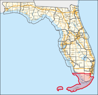
Florida's 28th congressional district is a new district created as a result of the 2020 census. The first candidates ran in the 2022 House elections for a seat in the 118th United States Congress. The district was created during the 2020 redistricting cycle as the successor to the previous 26th district in the 2010s. It includes all of Monroe County, home to the Florida Keys, and many of Miami's outer southwestern suburbs, including all of Homestead, The Hammocks, Kendale Lakes, Tamiami, and others. All three of Florida's national parks – the Everglades, Biscayne, and the Dry Tortugas – are also located in this district.
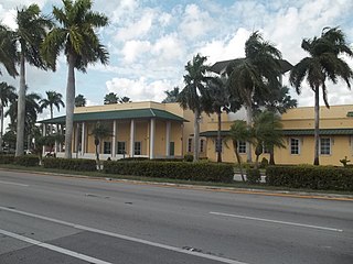
John Latham Volk was an Austrian-born American architect who designed public buildings and private residences in and around Palm Beach, Florida from the 1920s until his death in 1984. Although there is no particular style exclusively associated with Volk, he worked with many styles from Mediterranean Revival to Modern. Volk was among a group of architects considered the “Big Five,” along with Marion Sims Wyeth, Addison Mizner, Maurice Fatio, and Howard Major, who defined Palm Beach style in the early twentieth century.


