Wisteria Island

Last updated

Wisteria Island
Aerial photographs of Florida MM00032973 (5990911676).jpg
Wisteria Island in the lower Florida Keys, about 600 yards northwest of Downtown Key West, Florida
USA Florida relief location map.jpg
Red pog.svg
Wisteria Island
Wisteria Island
La2-demis-caribbean.png
Red pog.svg
Wisteria Island
Wisteria Island (Caribbean)
Geography
Location Gulf of Mexico
Coordinates 24°34′04″N81°48′39″W / 24.5678°N 81.8108°W / 24.5678; -81.8108
Administration
State Florida
County Monroe

Wisteria Island is a federally owned, uninhabited island in the lower Florida Keys 645 yards (590 m) northwest of the northwestern corner of the main island and city of Key West, Florida, Monroe County, United States. It is located 280 yards (260 m) north-northeast of Sunset Key (Tank Island), its closest neighbor.

Contents

Wisteria Island's area is 106,346 square meters (10.6346 ha) (26 acres). [1]

History

Wisteria Island was created in the late 1890s and early 1900s as the result of U.S. Navy dredging of Key West harbor. During the 19th century, sediment from repeated dredging projects was deposited a few hundred yards/meters off the northwestern corner of Key West, creating Tank Island (Sunset Key). Over the years, additional dredging projects created larger piles of sediment, eventually creating Wisteria Island. In 1925, [2] the U.S. Public Health Service disinfecting steamer Wisteria, [3] formerly a United States Lighthouse Service (one of the predecessors of the U.S. Coast Guard) light tender, sank where she was moored on the island and then burned to her waterline. [4] [5] The wreck was eventually salvaged, but the formerly unnamed spit of land kept the name of the ship as a reminder. [6]

In the 1930s, the island was purchased from Monroe County by then-state representative Bernie Papy for $3,000. During the late 1930s and early 1940s, the island was the site of a "shark camp" owned by city building inspector Ray Knopp, which eventually grew into a commercial shark processing plant owned by Thompson Enterprises. The plant harvested sharks for their skins, turning them into clothing for sale to markets as far away as China. [7]

In 1956, Papy sold the island to Wisteria Corp., a group formed with the intent of developing the island into commercial space and real estate. Wisteria Corp. was renamed to Wisteria Island, Inc. when it sold the island in 1967 to F.E.B. Corporation of Key West. Benjamin Bernstein, a prominent local real estate developer, was the principal behind the project and intended to develop the island into residential space. It totaled 21.5 acres (8.7 ha) at the time of the sale. F.E.B. subsequently negotiated the purchase of 150 acres (61 ha) of bay bottom surrounding the island from Monroe County, a transaction that took place the same year.

Annexation attempt

In April 2007, F.E.B. owner Roger Bernstein formally requested that the city of Key West annex the island, which had been considered a portion of unincorporated Monroe County. [8] This would have allowed 168 units to be built on the island, due to the denser building codes of Key West compared with those of Monroe County. [9] On May 1, 2007, the Key West City Commission, in a 5–2 vote, approved the first reading of an ordinance calling for the annexation of the island. Public opposition soon mounted and the second reading was tabled several times while voters gathered signatures for a petition opposing the high-density development plan. By July 10, 2007, over 3,000 signatures had been collected.

In a Key West City Commission meeting that evening, attorneys for Christmas Key Management Corporation announced that F.E.B. was withdrawing its request to have the island annexed to the city of Key West. At the same meeting, opponents of the plan announced that they would seek the inclusion of a non-binding referendum on the issue in the October 2007 city elections in order to gauge city support for curtailing development. [10] One week later, a motion to include the referendum in the October 2 Key West City election ballot was turned down after several citizens and City Commissioners questioned its necessity after F.E.B. withdrew its annexation request. [11]

In the wake of the failed county proposal, Key West Mayor Morgan McPherson proposed that the city of Key West purchase the island for conservation purposes. The idea, which was discussed in several City Commission meetings, was eventually tabled and the subject dropped.

Wisteria Island Wisteria Island, Key West, FL, US.jpg
Wisteria Island

Development plans

Over a period of forty years, two separate developers have attempted to turn Wisteria Island into upscale housing and commercial real estate. In 1966, real estate developers David W. Wolkowsky and Clayton Partin announced they would be developing the island into a 60-home community complete with a small golf course, yacht club, dredged canals, and a lagoon in the center of the island. Wolkowsky and Partin hired a group of architectural consultants who had previously worked on the Lincoln Center. The design, which would have featured small bungalows scattered around a central lagoon, was estimated to cost $5 million at the time. The project was eventually abandoned, however, and the island lay empty of permanent inhabitants.

In 2007, F.E.B. announced a partnership with Ocean Properties, Limited. The partnership intends to develop the island in a manner similar to that of neighboring Sunset Key (Tank Island), which features high-value condominiums and vacation homes. Infrastructure for the development is still in the planning stages, but as the island currently has no electrical, sewer, or water connections, these would have to be developed. Key West city officials estimated a $20 million cost to develop the infrastructure needed for the island and to link it to Key West. Development plans are still in a state of flux, but initial drafts call for a marina, small shops, and affordable homes. [6] On July 10, 2007, attorneys for the Christmas Key Management Corporation announced that F.E.B. was withdrawing an annexation request that would have included the island in the city of Key West proper. Under Key West's more relaxed building codes, 168 units could have been built on the island. Under Monroe County building codes, only two units can be built on the island, unless an exemption is granted. [9] This fact made large-scale development of the island unlikely.

Ownership

In November 2011, the United States Department of the Interior (DOI) determined that the federal government actually owned the island, which it said had been under the stewardship of the United States Fish and Wildlife Service for almost fifty years. The DOI had originally indicated that because the island was made from fill and was not naturally occurring, it did not belong to the federal government. However, subsequent research by the DOI revealed presidential executive orders from 1908 and 1924 directing that the island be reserved for Navy use, and a 1962 executive order transferring ownership from the Navy to the Fish and Wildlife Service. [12]

In 2020, a U.S. District Court judge ruled that the federal government owns Wisteria Island, as it was created by the Navy as a fill for dredging operations, and its deed was transferred from the Navy to the Department of the Interior in 1982. [13]

Under Florida law, F.E.B. is entitled to seek a refund for having paid property taxes on Wisteria Island, but such a refund extends only to two years' worth of paid taxes. [12]

Related Research Articles

<span class="mw-page-title-main">Key Colony Beach, Florida</span> City in Florida, United States

Key Colony Beach is a municipality in the middle of the Florida Keys, Monroe County, Florida, United States. The population was 790 at the 2020 census.

<span class="mw-page-title-main">Key West</span> Island and city in Florida, United States

Key West is an island in the Straits of Florida, within the U.S. state of Florida. Together with all or parts of the separate islands of Dredgers Key, Fleming Key, Sunset Key, and the northern part of Stock Island, it constitutes the City of Key West.

<span class="mw-page-title-main">Tierra Verde, Florida</span> Census-designated place in Florida, United States

Tierra Verde is a census-designated place (CDP) in Pinellas County, Florida, United States. The population was 3,721 at the 2010 census. The community is located on an island near the entrance of Tampa Bay, and is connected by the bridges of the Pinellas Bayway to both St. Petersburg and St. Pete Beach. At the southern end of Tierra Verde is Fort De Soto, a county park.

<span class="mw-page-title-main">Conch Republic</span> Micronation of Key West, Florida

The Conch Republic is a micronation declared as a sarcastic secession of the city of Key West, Florida, from the United States on April 23, 1982. It has been maintained as a tourism booster for the city. Since then, the term "Conch Republic" has been expanded to refer to "all of the Florida Keys, or, that geographic apportionment of land that falls within the legally defined boundaries of Monroe County, Florida, northward to 'Skeeter's Last Chance Saloon' in Florida City, Dade County, Florida, with Key West as the micronation's capital and all territories north of Key West being referred to as 'The Northern Territories'".

<span class="mw-page-title-main">Florida Keys</span> Coral cay archipelago in Florida, United States

The Florida Keys are a coral cay archipelago off the southern coast of Florida, forming the southernmost part of the continental United States. They begin at the southeastern coast of the Florida peninsula, about 15 miles (24 km) south of Miami and extend in a gentle arc south-southwest and then westward to Key West, the westernmost of the inhabited islands, and on to the uninhabited Dry Tortugas. The islands lie along the Florida Straits, dividing the Atlantic Ocean to the east from the Gulf of Mexico to the northwest, and defining one edge of Florida Bay. The southern part of Key West is 93 miles (150 km) from Cuba. The Keys are located between about 24.3 and 25.5 degrees North latitude.

<span class="mw-page-title-main">Key Biscayne</span> Island in Florida, United States

Key Biscayne is an island located in Miami-Dade County, Florida, located between the Atlantic Ocean and Biscayne Bay. It is the southernmost of the barrier islands along the Atlantic coast of Florida, and lies south of Miami Beach and southeast of Miami. The key is connected to Miami via the Rickenbacker Causeway, originally built in 1947.

<span class="mw-page-title-main">Florida panhandle</span> Northwest region of Florida

The Florida panhandle is the northwestern part of the U.S. state of Florida. It is a salient roughly 200 miles (320 km) long, bordered by Alabama on the north and the west, Georgia on the north, and the Gulf of Mexico to the south. Its eastern boundary is arbitrarily defined. It is defined by its southern culture and rural geography relative to the rest of Florida, as well as closer cultural links to French-influenced Louisiana, Mississippi, and Alabama. Its major communities include Pensacola, Navarre, Destin, Panama City Beach, and Tallahassee.

<span class="mw-page-title-main">Overseas Highway</span> Highway through the Florida Keys to Key West, Florida, USA

The Overseas Highway is a 113-mile (181.9 km) highway carrying U.S. Route 1 (US 1) through the Florida Keys to Key West. Large parts of it were built on the former right-of-way of the Overseas Railroad, the Key West Extension of the Florida East Coast Railway. Completed in 1912, the Overseas Railroad was heavily damaged and partially destroyed in the 1935 Labor Day hurricane. The Florida East Coast Railway was financially unable to rebuild the destroyed sections, so the roadbed and remaining bridges were sold to the state of Florida for $640,000.

<span class="mw-page-title-main">Summerland Key</span> Unincorporated community in Florida, United States

Summerland Key is an island in the lower Florida Keys about 20 miles (32 km) east of Key West; it contains an unincorporated community of Monroe County of the same name.

<span class="mw-page-title-main">Sunset Key</span> Island in the Florida Keys

Sunset Key is a 27-acre (11-hectare) residential neighborhood and resort island in the city of Key West, Florida. It is located about 500 yards (460 m) off the coast of the island of Key West. The island is privately held among its residents. The island is accessible only by a shuttle boat that runs from the Margaritaville Marina out to the island. As of 2006, the island consisted of a total of 48 single-family homes and 21 vacant lots.

<span class="mw-page-title-main">Ballast Key</span> Island in the Florida Keys, United States

Ballast Key is an island in the Florida Keys in Monroe County, Florida, United States. It is the southernmost point of land in the contiguous United States. It was the last privately owned land within the boundaries of the Key West National Wildlife Refuge.

<span class="mw-page-title-main">Stock Island</span> Island in the Florida Keys

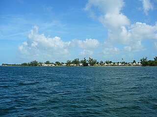
Stock Island is an island in the lower Florida Keys immediately east of Key West. Immediately northwest is Key Haven, from which it is connected by causeway with US 1. The part north of U.S. 1 is part of the City of Key West, while the southern part is a census-designated place (CDP) in Monroe County, Florida, United States. The population of the CDP was 4,410 at the 2000 census. Stock Island was supposedly named for herds of livestock formerly kept there. Alternatively, some local historians suggest that it may be named for an early settler.

<span class="mw-page-title-main">Rickenbacker Causeway</span> Bridge in Florida, United States of America

The Rickenbacker Causeway is a causeway that connects Miami, Florida to the barrier islands of Virginia Key and Key Biscayne across Biscayne Bay.

<span class="mw-page-title-main">Truman Annex</span>

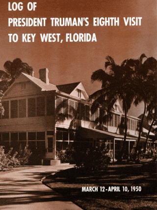
Truman Annex is both a neighborhood and military installation in Key West, Florida, United States. It is the part of the island that is west of Whitehead Street, with the exception of Bahama Village. The winter White House for President Harry S. Truman was located there, from its days as part of the former Naval Station Key West. The Harry S. Truman Little White House in Key West, Florida was the winter White House for President Truman for 175 days during 11 visits.

<i>Western Union</i> (schooner)

Western Union is a historic schooner located in Key West, Florida, United States. She is berthed at the Key West Bight at 202 William Street. Western Union is the last surviving authentic working tall ship built in Florida. On May 16, 1984, Western Union was added to the US National Register of Historic Places. She is also the official flagship of the State of Florida and the flagship of the city of Key West.

<span class="mw-page-title-main">Mule Keys</span> Archipelago in Monroe County, Florida, U.S.

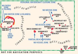
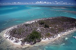
The Mule Keys are a group of scattered islets in the Florida Keys in Monroe County, Florida, United States. They are between 3 and 12 mi west of Key West, separated from it by the Northwest Channel. On the west, they are separated from the Marquesas Keys by the 6-mile (9.7 km) wide Boca Grande Channel. They belong to the outlying islands of the Florida Keys. Administratively, they are an unincorporated area of Monroe County. The islets are part of the Key West National Wildlife Refuge. The area of the islets totals 1.07 sq mi (2.8 km2), of which 1.02 sq mi (2.6 km2) are land area and 0.05 sq mi (0.13 km2) inland water bodies. The islets are uninhabited except for Mule Key, for which the census of 2000 lists one housing unit with a population of two.

<span class="mw-page-title-main">Sigsbee Park</span> Island in the Florida Keys

Sigsbee Park, also known as Dredgers Key, is an island about half a mile (800 m) north of Key West island in the lower Florida Keys; administratively it is within the City of Key West, Florida, United States.

The Florida Keys Keynoter is a twice-weekly broadsheet format newspaper owned by The McClatchy Company and is a subsidiary of the Miami Herald. It primarily serves Monroe county in the U.S. state of Florida. In addition to publishing regular issues on Wednesday and Saturday, the Keynoter also publishes the quarterly magazine Unwind. The Keynoter is a partner of the Upper Keys Reporter, which specializes in coverage of the Upper Florida Keys, including Key Largo.

David William Wolkowsky was a real estate developer from Key West, Florida. He is credited with transforming the city from a navy town to a tourist destination.

<span class="mw-page-title-main">Port of Key West</span> Port in United States

The Port of Key West is a port in Key West, Florida. It includes Key West Bight, Garrison Bight at City Marina, as well as three docks that could be utilized by cruise ships.

References

  1. "U.S. Census website". United States Census Bureau . Retrieved April 22, 2014.
  2. 1925 and 1926 Annual List of Merchant Vessels of the United States, with Official Numbers and Signals, Department of Commerce and Labor. Official records indicate the hulk of the Wisteria sank sometime between 1925-1926
  3. 1910 Annual List of Merchant Vessels of the United States, with Official Numbers and Signals, Department of Commerce and Labor
  4. U.S. Coast Guard Records
  5. United States Lighthouse Service Tenders, 1840-1939. Annapolis, Eastwind Publishing, 2000
  6. 1 2 Key West Citizen, April 29, 2007
  7. Key West Citizen, Feb. 24, 1966
  8. Key West Keynoter, April 18, 2007, pg. 1
  9. 1 2 Florida Keys Keynoter, July 11, 2007. Pgs. 1, 4.
  10. Florida Keys Keynoter, July 11, 2007. Page 4.
  11. Key West Citizen, July 18, 2007.
  12. 1 2 Goodhue, David (November 22, 2011). "Feds: We own Wisteria Island in Key West". Miami Herald . Retrieved November 22, 2011.
  13. Filosa, Gwen (August 6, 2020). "Federal judge rules the government owns an undeveloped island off Key West — not a developer". Miami Herald. Retrieved April 24, 2021.