Olympic National Forest

Last updated

Olympic National Forest
Mount Zion - west slope, Olympic National Forest.jpg
Panorama view from Mount Zion
USA Washington relief location map.jpg
Red pog.svg
Usa edcp relief location map.png
Red pog.svg
Location Washington, U.S.
Nearest city Quinault, WA
Coordinates 47°48′35.9″N123°4′0.2″W / 47.809972°N 123.066722°W / 47.809972; -123.066722
Area628,115 acres (2,541.89 km2) [1]
EstablishedFebruary 22, 1897 [2]
Governing body U.S. Forest Service
Website Olympic National Forest

Olympic National Forest is a U.S. National Forest located in Washington, USA. With an area of 628,115 acres (254,189 ha), it nearly surrounds Olympic National Park and the Olympic Mountain range. Olympic National Forest contains parts of Clallam, Grays Harbor, Jefferson, and Mason counties. The landscape of the national forest varies, from the temperate Olympic rain forest to the salt water fjord of Hood Canal to the peaks of Mt. Washington.

Contents

Annual precipitation averages about 220 inches (5,600 mm), giving rise to streams such as the Humptulips River.

Olympic National Forest was originally created as Olympic Forest Reserve in 1897, [3] then renamed to Olympic National Forest in 1907. [4] A portion of the National Forest became the Mount Olympus National Monument in 1909, which was later designated Olympic National Park. [5]

A 1993 Forest Service study estimated that the extent of old growth in the Forest was 266,800 acres (108,000 ha). [6] It is administered in two ranger districts: the Pacific Ranger District on the west side of the Olympic Peninsula, and the Hood Canal Ranger District on the east side.

Forest headquarters are located in Olympia, with ranger district offices in Forks, Quinault, and Quilcene. The former office in Hoodsport closed in 2005, and now houses a local Chamber of Commerce, which still sells Northwest Forest Passes.

Other Washington towns near entrances of the forest include Port Angeles, Sequim, and Amanda Park.

Points of interest

View of Puget Sound from the top of Mt. Walker TopofMtWalker.JPG
View of Puget Sound from the top of Mt. Walker

Wilderness areas

Buckhorn, Iron Mountains from Marmot Pass.jpg
Panorama looking West-Northwest to Northeast from Marmot Pass in the Buckhorn Wilderness. Buckhorn Mountain and Iron Mountain can be seen on the far right side.

Wild Olympics

The Wild Olympics campaign is an effort to designate additional areas on the Olympic Peninsula as protected.

Under a bill introduced by United States Senator Patty Murray in January 2014 logging on an additional 126,554 acres (20%) of the Olympic National Forest's lands would be disallowed under the creation of nine new wilderness areas and expansion of the five existing ones. Wild and Scenic River designations would extend to 19 rivers, including those originating in the Olympic National Park, such as the Quinault, Hoh, Elwha, and Hamma Hamma, and some that do not, like the Middle Fork of the Satsop River. [7] [8] According to The Oregonian, "the wilderness designation would permanently protect old growth and ancient forest habitat throughout the region. The wild and scenic rivers designation would add federal recognition to the outstanding river systems on the peninsula, protecting them as a source of clean drinking water and helping to keep Puget Sound clean for generations. This designation does not restrict private property rights." [9]

Like the Northern Spotted Owl controversy two decades earlier, [10] the action has met opposition from some residents on and near the Olympic Peninsula who see it as a threat to their livelihoods. Handmade "Stop Wild Olympics" signs can be seen in the Aberdeen area and on the peninsula, expressing displeasure, [8] [11] and an opposition group, Working Wild Olympics, was set up in 2011. [12] The effort has the support of dozens of "major hunting and fishing organizations" who see it as a way to sustain elk, salmon and other fish. [13] [14] [15] Debate on the topic in 2014 has included community meetings drawing hundreds of individuals on both sides, and full-page advertisements in local newspapers. [16]

An episode of This American Land concerning the Wild Olympics proposal showed nationally on PBS in 2014. [17]

The Wild Olympics Wilderness and Wild and Scenic Rivers Act was reintroduced in 2019 as H.R.2642 and received a hearing in the House Natural Resources Subcommittee on National Parks, Forests, and Public Lands. [18]

Related Research Articles

<span class="mw-page-title-main">Olympic National Park</span> National park in Washington state, United States

Olympic National Park is a United States national park located in the State of Washington, on the Olympic Peninsula. The park has four regions: the Pacific coastline, alpine areas, the west-side temperate rainforest, and the forests of the drier east side. Within the park there are three distinct ecosystems, including subalpine forest and wildflower meadow, temperate forest, and the rugged Pacific coast.

<span class="mw-page-title-main">Olympic Mountains</span> Mountain range in Washington, United States

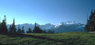
The Olympic Mountains are a mountain range on the Olympic Peninsula of the Pacific Northwest of the United States. The mountains, part of the Pacific Coast Ranges, are not especially high – Mount Olympus is the highest summit at 7,980 ft (2,432 m); however, the eastern slopes rise precipitously out of Puget Sound from sea level, and the western slopes are separated from the Pacific Ocean by the low-lying 20 to 35 km wide Pacific Ocean coastal plain. These densely forested western slopes are the wettest place in the 48 contiguous states. Most of the mountains are protected within the bounds of Olympic National Park and adjoining segments of the Olympic National Forest.

<span class="mw-page-title-main">Mount Baker–Snoqualmie National Forest</span> Protected area in the United States

The Mount Baker–Snoqualmie National Forest in Washington is a National Forest extending more than 140 miles (230 km) along the western slopes of the Cascade Range from the Canada–US border to the northern boundary of Mount Rainier National Park. Administered by the United States Forest Service, the forest is headquartered in Everett. There are local ranger district offices in North Bend and Skykomish.

<span class="mw-page-title-main">Olympic Peninsula</span> Peninsula in Washington, United States

The Olympic Peninsula is a large arm of land in western Washington that lies across Puget Sound from Seattle, and contains Olympic National Park. It is bounded on the west by the Pacific Ocean, the north by the Strait of Juan de Fuca, and the east by Hood Canal. Cape Alava, the westernmost point in the contiguous United States, and Cape Flattery, the northwesternmost point, are on the peninsula. Comprising about 3,600 square miles (9,300 km2), the Olympic Peninsula contained many of the last unexplored places in the contiguous United States. It remained largely unmapped until Arthur Dodwell and Theodore Rixon mapped most of its topography and timber resources between 1898 and 1900.

<span class="mw-page-title-main">Lake Quinault</span> Lake in Grays Harbor County, Washington, USA

Lake Quinault is a lake on the Olympic Peninsula in western Washington state. It is located in the glacial-carved Quinault Valley of the Quinault River, at the southern edge of Olympic National Park in the northwestern United States. One of the most dominant features of Lake Quinault is its location within the Quinault Rainforest, a temperate rain forest.

<span class="mw-page-title-main">Protected areas of the United States</span> Legally protected land, eg national parks

The protected areas of the United States are managed by an array of different federal, state, tribal and local level authorities and receive widely varying levels of protection. Some areas are managed as wilderness, while others are operated with acceptable commercial exploitation. As of 2022, the 42,826 protected areas covered 1,235,486 km2 (477,024 sq mi), or 13 percent of the land area of the United States. This is also one-tenth of the protected land area of the world. The U.S. also had a total of 871 National Marine Protected Areas, covering an additional 1,240,000 sq mi (3,200,000 km2), or 26 percent of the total marine area of the United States.

<span class="mw-page-title-main">Gifford Pinchot National Forest</span> Protected area in the state of Washington, United States

Gifford Pinchot National Forest is a National Forest located in southern Washington, managed by the United States Forest Service. With an area of 1.32 million acres (5300 km2), it extends 116 km (72 mi) along the western slopes of Cascade Range from Mount Rainier National Park to the Columbia River. The forest straddles the crest of the South Cascades of Washington State, spread out over broad, old growth forests, high mountain meadows, several glaciers, and numerous volcanic peaks. The forest's highest point is at 12,276 ft (3,742 m) at the top of Mount Adams, the second tallest volcano in the state after Rainier. Often found abbreviated GPNF on maps and in texts, it includes the 110,000-acre (450 km2) Mount St. Helens National Volcanic Monument, established by Congress in 1982.

<span class="mw-page-title-main">George Washington and Jefferson National Forests</span> Pair of National Forests in the United States

The George Washington and Jefferson National Forests is an administrative entity combining two U.S. National Forests into one of the largest areas of public land in the Eastern United States. The forests cover 1.8 million acres (2,800 sq mi) of land in the Appalachian Mountains of Virginia, West Virginia, and Kentucky. Approximately 1 million acres (1,600 sq mi) of the forest are remote and undeveloped and 139,461 acres (218 sq mi) have been designated as wilderness areas, which prohibits future development.

The protected areas of Michigan come in an array of different types and levels of protection. Michigan has five units of the National Park Service system. There are 14 federal wilderness areas; the majority of these are also tribal-designated wildernesses. It has one of the largest state forest systems as well having four national forests. The state maintains a large state park system and there are also regional parks, and county, township and city parks. Still other parks on land and in the Great Lakes are maintained by other governmental bodies. Private protected areas also exist in the state, mainly lands owned by land conservancies.

<span class="mw-page-title-main">Kalaloch, Washington</span> Unincorporated community in Washington, United States

Kalaloch is an unincorporated resort area entirely within Olympic National Park in western Jefferson County, Washington, United States. Kalaloch accommodations are on a 50-foot (15 m) bluff overlooking the Pacific Ocean, west of U.S. Route 101 on the Olympic Peninsula, north of the reservation of the Quinault Indian Nation.

<span class="mw-page-title-main">Alpine Lakes Wilderness</span> Wilderness area in Washington (state)

The Alpine Lakes Wilderness is a large wilderness area spanning the Central Cascades of Washington state in the United States. The wilderness is located in parts of Wenatchee National Forest and Snoqualmie National Forest, and is approximately bounded by Interstate 90 and Snoqualmie Pass to the south and U.S. Route 2 and Stevens Pass to the north. The Alpine Lakes is the largest wilderness area near the population centers of Puget Sound, counted at 414,161 acres (167,605 ha) following the 2014 expansion.

<span class="mw-page-title-main">National Wilderness Preservation System</span> Protection of wilderness areas in the U.S.

The National Wilderness Preservation System (NWPS) of the United States protects federally managed wilderness areas designated for preservation in their natural condition. Activity on formally designated wilderness areas is coordinated by the National Wilderness Preservation System. Wilderness areas are managed by four federal land management agencies: the National Park Service, the U.S. Forest Service, the U.S. Fish and Wildlife Service, and the Bureau of Land Management.

<span class="mw-page-title-main">National Conservation Lands</span> Group of federally-managed protected areas in the United States

National Conservation Lands, formally known as the National Landscape Conservation System, is a 35-million-acre (140,000 km2) collection of lands in 873 federally recognized areas considered to be the crown jewels of the American West. These lands represent 10% of the 258 million acres (1,040,000 km2) managed by the Bureau of Land Management (BLM). The BLM is the largest federal public land manager and is responsible for over 40% of all the federal public land in the nation. The other major federal public land managers include the US Forest Service (USFS), National Park Service (NPS), and the US Fish and Wildlife Service (USFWS).

<span class="mw-page-title-main">The Wilderness Society (United States)</span> American non-profit land conservation organization

The Wilderness Society is an American non-profit land conservation organization that is dedicated to protecting natural areas and federal public lands in the United States. They advocate for the designation of federal wilderness areas and other protective designations, such as for national monuments. They support balanced uses of public lands, and advocate for federal politicians to enact various land conservation and balanced land use proposals. The Wilderness Society also engages in a number of ancillary activities, including education and outreach, and hosts one of the most valuable collections of Ansel Adams photographs at their headquarters in Washington, D.C.

<span class="mw-page-title-main">Ellicott Rock Wilderness</span>

Ellicott Rock Wilderness is managed by the United States Forest Service and is part of the National Wilderness Preservation System. It was first designated by Congress in 1975 with the Eastern Wilderness Act. Most of this land lays in South Carolina. Additional lands were added to Ellicott Rock Wilderness in 1984 with the passing of the North Carolina Wilderness Act and the Georgia Wilderness Act, today designated wilderness totals 8,274 acres (33.48 km2). Ellicott Rock Wilderness is the only wilderness that straddles three states, with boundaries located around the point at which Georgia, North Carolina, and South Carolina come together. Ellicott Rock Wilderness also spans three National Forests. Sumter National Forest in South Carolina is responsible for 2,859 acres (11.57 km2), receives the majority of recreation in the wilderness, and is also the lead manager of Ellicott Rock Wilderness. Nantahala National Forest in North Carolina is responsible for most of the wilderness at 3,394 acres (13.74 km2) and the Chattahoochee National Forest in Georgia manages 2,021 acres (8.18 km2) of the wilderness. In 1979, all Forest Service land was surveyed under the Roadless Area Review and Evaluation and 1,982 acres (8.02 km2) on the Sumter National Forest were classified as Roadless National Forest System land and named Ellicott Rock Extension. The Andrew Pickens Ranger district on the Sumter National Forest recommended the Ellicott Rock Extension as wilderness in 1995 in their Resource Management Plan. Although not fully designated, recommended wilderness is managed as if it were designated wilderness. In June 2017 during a land management plan revision, the Nantahala Ranger District on the Nantahala National Forest added 824 acres (3.33 km2) of proposed wilderness, currently called Ellicott Rock West Extension.

<span class="mw-page-title-main">Opal Creek Wilderness</span> Wilderness area in the Willamette National Forest

The Opal Creek Wilderness is a wilderness area located in the Willamette National Forest in the U.S. state of Oregon, on the border of the Mount Hood National Forest. It has the largest uncut watershed in Oregon.

<span class="mw-page-title-main">Protected areas of California</span> Protected environmental areas of California, US

According to the California Protected Areas Database (CPAD), in the state of California, United States, there are over 14,000 inventoried protected areas administered by public agencies and non-profits. In addition, there are private conservation areas and other easements. They include almost one-third of California's scenic coastline, including coastal wetlands, estuaries, beaches, and dune systems. The California State Parks system alone has 270 units and covers 1.3 million acres (5,300 km2), with over 280 miles (450 km) of coastline, 625 miles (1,006 km) of lake and river frontage, nearly 18,000 campsites, and 3,000 miles (5,000 km) of hiking, biking, and equestrian trails.

<span class="mw-page-title-main">U.S. Route 101 in Washington</span> Section of U.S. Highway 101 in Washington (state), United States

U.S. Route 101 (US 101) is a United States Numbered Highway that runs along the West Coast from Los Angeles, California to Tumwater, Washington. Within the state of Washington, US 101 connects cities on the coast of the Pacific Ocean and encircles the Olympic Peninsula around the Olympic Mountains. It also serves as the main access for Olympic National Park, several state parks, and other scenic and recreational areas.

<span class="mw-page-title-main">Mount Skokomish Wilderness</span>

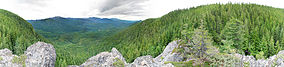
Mount Skokomish Wilderness is a designated wilderness area in the southeast portion of Olympic National Forest on the Olympic Peninsula of Washington in the United States. The wilderness area comprises 13,291 acres (5,379 ha) administered by the U.S. Forest Service.

<span class="mw-page-title-main">John D. Dingell Jr. Conservation, Management, and Recreation Act</span> United States federal omnibus lands act

The John D. Dingell Jr. Conservation, Management, and Recreation Act of 2019 is an omnibus lands act that protected public lands and modified management provisions. The bill designated more than 1,300,000 acres (5,300 km2) of wilderness area, expanded several national parks and other areas of the National Park System, and established four new national monuments while redesignating others. Other provisions included making the Land and Water Conservation Fund permanent, protecting a number of rivers and historic sites, and withdrawing land near Yellowstone National Park and North Cascades National Park from mining.

References

  1. "Land Areas of the National Forest System" (PDF). U.S. Forest Service. January 2012. Retrieved June 30, 2012.
  2. "The National Forests of the United States" (PDF). ForestHistory.org. Archived from the original (PDF) on March 11, 2012. Retrieved April 2, 2018.
  3. Kit Oldham (January 12, 2003), "President Grover Cleveland proclaims Olympic Forest Reserve on February 22, 1897", HistoryLink , Seattle: History Ink, retrieved July 16, 2022
  4. "Olympic National Forest History & Culture". US Forest Service. Retrieved July 16, 2022.
  5. "Olympic National Park - History & Culture". US National Park Service. Retrieved July 16, 2022.
  6. Bolsinger, Charles L.; Waddell, Karen L. (1993), Area of old-growth forests in California, Oregon, and Washington (PDF), United States Forest Service, Pacific Northwest Research Station, Resource Bulletin PNW-RB-197
  7. Ollikainen, Rob (January 18, 2014), "Forestry group opposes Wild Olympics legislation introduced by lawmaker", Peninsula Daily News , Port Angeles, Washington
  8. 1 2 Ahearn, Ashley (January 17, 2014), "Legislation Revived To Protect 126,000 Acres Of Olympic Peninsula", KUOW-FM , Seattle, Washington
  9. "Wild Olympics, scenic rivers act introduced in Congress". OregonLive.com. June 4, 2015. Retrieved April 18, 2016.
  10. Bruscas, Angelo (May 11, 2012), "Wild Olympics — not much middle ground", The Daily World, Aberdeen, Washington, The first part of the event featured 30-minute presentations from the Wild Olympics campaign and from the group opposed to it, Working Wild Olympics...a retired logger...said the proposal "totally ignores the last 20 years of what has happened here on the Harbor" after the federal 1994 Northwest Forest Plan curtailed logging in an attempt to preserve spotted owl habitat.
  11. "More anti Wild Olympic signs going up locally", KXRO , Aberdeen, Washington, September 30, 2013, archived from the original on August 21, 2019
  12. Friederich, Steven (September 23, 2011), "Working Wild Olympics -- Timber workers have their say", The Daily World, Aberdeen, Washington, The Working Wild Olympics Coalition, made up of timber interests and supporters, was convened to directly oppose the Wild Olympics Campaign, made up of conservation and recreation groups who want to see more protections brought on areas surrounding Olympic National Park.
  13. "Wild Olympics have Olympic Peninsula hunting and fishing support", KXRO , Aberdeen, Washington, February 5, 2014, archived from the original on August 21, 2019
  14. "Sportsmen for Wild Olympics announce new endorsements & video", KBKW , Aberdeen, Washington, February 5, 2014, archived from the original on November 29, 2014
  15. "Endorsements". Wild Olympics Campaign. Retrieved August 21, 2019.
  16. Couhig, Mark St.J. (March 20, 2014), "Wild Olympics debate heating up", Sequim Gazette, Sequim, Washington
  17. "Wild Olympics Campaign featured on "This American Land"", The Conservation Alliance, July 9, 2014
  18. Kilmer, Derek (July 10, 2019). "H.R.2642 - 116th Congress (2019-2020): Wild Olympics Wilderness and Wild and Scenic Rivers Act". www.congress.gov. Retrieved August 21, 2019.