Forks was once inhabited by the QuileuteNative American tribe, before they ceded their territory.[6] In 1889 a reservation was created near Forks; that same year the village was burnt down by settler Daniel Pullen. Forks is 12 miles from tribal burning areas that area tribes used to regenerate young ferns. The phrase "prairie upstream" from Quileute language was translated and became the name Forks Prairie.[6]
Early settlement
The first European American settlers in the modern-day Forks Prairie arrived in the 1860s by following the waterways in and around the Olympic Peninsula due to a lack of overland trails. A proposal to create Quillehuyte County from the western sides of Clallam and Jefferson counties was accepted by the territorial legislature in 1868 but dissolved a year later.[citation needed] The first homestead on the prairie was claimed in January 1878 by Luther and Esther Ford. Their 160-acre (65ha) property included the first dairy in the area, set up in 1879, and was later joined by other homesteads. A post office opened in the cabin of Ole Nelson, a local trapper, in 1884 and was named "Forks"; their preferred name "Ford's Prairie" had already been taken by another settlement in the territory.[6] The name "Forks" was chosen for the forks of three nearby rivers.[6]
Rudimentary trails and roads were built by settlers in the 1880s and 1890s to create trade routes; the nearest markets were in Port Townsend and later Port Angeles, but the seasonal supply boats were unable to take large cargo.[6] Timber around the prairie was cleared by settlers and small-time loggers in the late 19th century. They were followed by timber companies, including Merrill & Ring around the Pysht River in 1916, until the Olympic Forest Reserve was established in 1897 by the federal government. The forest reserve was gradually reduced in size but later contributed most of the land for Olympic National Monument (now Olympic National Park), which was established in 1909, and the Olympic National Forest.[6] Logging of non-federal land continued, but slowed during the 1907 national recession. The U.S. Army sought to use the region's Sitka spruce to construct airplanes during World War I and built a 36-mile (58km) railroad to Port Angeles to aid in transport; the railroad was not used due to the end of the war.[6]
The Mora post moved to Forks in the early 1890s which consisted of a general store, hardware store, and a hotel. In the early 1900s, hop growing declined and the Forks Cooperative Creamery was established which operated for 70 years.[6] The town of Forks was platted in 1912 on the homestead of Merrill Whittier, a hop farmer. It served as the economic center of the area between the Hoh River and Quillayute Prairie but only had a single block of buildings in its first decade.[6] A fire on January 10, 1925, destroyed six buildings on the west side of the town; they were replaced later in the year along with plans for a new high school and social halls.[7] A new road passable for automobiles opened from Lake Crescent to Forks in 1927 and was replaced by the Olympic Loop Highway (US 101) in 1931.[6] Another fire on Main Street in 1930 caused further damage.[6]
Modern history
Forks was officially incorporated on August 7, 1945,[6] following an election of the constituents who would become its first town members.[citation needed]
The local timber industry boomed from the 1950s to 1970s, earning Forks the self-proclaimed title of "Logging Capital of the World." Changes in environmental policy led to a significant decline in the timber industry in the 1980s and 1990s. Timber harvesting is still part of the local economy, but at levels far below the peak of the 1970s.[8]
The city gained popularity for being a key setting in Stephenie Meyer's Twilight series (2005 to 2008) and related film adaptations (2008 to 2012).
As of the 2010 census,[11] there were 3,532 people, 1,264 households, and 849 families residing in the city. The population density was 967.7 inhabitants per square mile (373.6/km2). There were 1,374 housing units at an average density of 376.4 per square mile (145.3/km2). The racial makeup of the city was 67.7% White, 0.5% African American, 6.6% Native American, 1.2% Asian, 0.1% Pacific Islander, 18.1% from other races, and 5.9% from two or more races. Hispanic or Latino people of any race were 25.9% of the population.
There were 1,264 households, of which 40.9% had children under the age of 18 living with them, 46.0% were married couples living together, 13.5% had a female householder with no husband present, 7.7% had a male householder with no wife present, and 32.8% were non-families. 25.3% of all households were made up of individuals, and 8.2% had someone living alone who was 65 years of age or older. The average household size was 2.72 and the average family size was 3.16.
The median age in the city was 31.3 years. 29.2% of residents were under the age of 18; 10.3% were between the ages of 18 and 24; 27.6% were from 25 to 44; 23.2% were from 45 to 64; and 9.7% were 65 years of age or older. The gender makeup of the city was 51.5% male and 48.5% female.
2000 census
As of the 2000 census, there were 3,120 people, 1,169 households, and 792 families residing in the city. The population density was 854.8 people per square mile (330.2/km2). There were 1,361 housing units at an average density of 435.6 per square mile (168.4/km2). The racial makeup of the city was 81.47% White, 0.42% African American, 5.03% Native American, 1.51% Asian, 0.16% Pacific Islander, 8.49% from other races, and 2.92% from two or more races. Hispanic or Latino people of any race were 3.54% of the population.
There were 1,169 households, out of which 36.9% had children under the age of 18 living with them, 49.4% were married couples living together, 11.4% had a female householder with no husband present, and 32.2% were non-families. 24.6% of all households were made up of individuals, and 7.4% had someone living alone who was 65 years of age or older. The average household size was 2.65 and the average family size was 3.15.
In the city, the age distribution of the population shows 30.4% under the age of 18, 11.1% from 18 to 24, 27.2% from 25 to 44, 22.1% from 45 to 64, and 9.1% who were 65 years of age or older. The median age was 31 years. For every 100 females, there were 111.7 males. For every 100 females age 18 and over, there were 108.9 males.
The median income for a household in the city was $34,280, and the median income for a family was $38,844. Males had a median income of $35,718 versus $23,690 for females. The per capita income for the city was $13,686. About 14.6% of families and 20.5% of the population were below the poverty line, including 25.7% of those under age 18 and 12.4% of those age 65 or over.
Forks has an ocean climate (Cfb) in a temperate rainforest with very high rainfall, above 100 inches (2,500mm) per year. Although there is a drying trend in summer, rain is still abundant, just not as wet as the rest of the year. Forks averages 212 days per year with measurable precipitation.[13]
The city is organized under Washington State law as a non-charter code city. Its structure is that of an elected mayor and a five-member elected city council. Unlike other cities on the Olympic Peninsula, Forks operates under what is called a "strong mayor" form of government with the mayor being the chief executive officer overseeing four department heads (clerk/treasurer, public works, police, and legal/planning).[21]
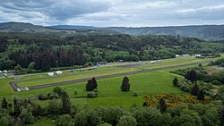
Forks Municipal Airport(FAALID: S18) is located in Clallam County, 1 mile (1.6km) southwest of Forks. The airport has six based aircraft, including 3 single-engine aircraft and 3 helicopters. The latest available data indicate that the airport had a total of 13,550 annual operations. Runway 4-22 is Forks Municipal Airport's sole runway. This runway is 2,400 feet (730m) long, 75 feet (23m) wide, is equipped with medium intensity runway lighting, and has an asphalt surface. Approaches to both ends of this runway are visual.[23]
Forks is served by two public transit agencies. Clallam Transit operates local service in Forks, including an on-demand microtransit system, as well as intercity routes to Port Angeles, La Push, and Neah Bay.[24] The "Olympic Connection" bus, operated by Jefferson Transit, travels between Forks and Lake Quinault, where riders are able to transfer to Grays Harbor Transit buses to Aberdeen.[25] The Olympic Connection was introduced in January 1995 to fill a 60-mile (97km) gap in transit service along the U.S. Route 101 corridor.[26][27]
Media
Newspapers serving Forks include the Peninsula Daily News and the weekly Forks Forum, known as "the farthest west newspaper in the contiguous United States."[28]
Forks Timber MuseumSigns related to the Twilight book/movie series that is set in Forks
In 2003, an executive on the economic development council noted that 'Forks is going through a transition from a logging community to a tourist community'.[31]
On the south end of town is the Forks Timber Museum. Constructed in 1989 by the Forks High School carpentry class, the 3,200-square-foot (300m2) building provides a look into the local history of the timber industry, loggers of the past, and their tools of the trade. The museum has exhibits depicting local history dating to the 1870s.[32]
Forks serves as the hub for numerous day excursions to the Hoh Rainforest, the Pacific Beaches, and various wilderness trails. Forks is well known for its winter steelhead fishing with the Quillayute river system – the Hoh, Sol Duc, Bogachiel and Calawah rivers. Other nearby Clallam, Sekiu, and Hoko rivers are also good for king salmon fishing and steelheading as well. Local guides are available for both native and hatchery runs and for float trips. Fishing gear and clothing is available at local stores.
Another source of tourism is Stephenie Meyer's Twilight series, which she set in the town after searching Google for rainy settings.[31] Tours are available of locations that resemble the places described in Meyer's books. The majority of the films were not shot in Forks, though key scenes were shot in the town and surrounding area.[31][33][34]
In December 2005, 74 visitors signed the guest book at the Forks Visitor Center; after the release of the Twilight series this increased substantially, with 2540 visitors signing in to the center in December 2009.[35] In July of that year, the number was 16,186.[31] The average annual number of tourists visiting the town rose from 10,000 before Twilight to 19,000 in 2008, the year of the first film, and 73,000 by 2010.[citation needed]
Tillicum Park
Forks Shay Engine
Forks displays one of a few Shay engines remaining in Washington. Shay locomotives are unusual in that they have a crank shaft running down the side, powering all wheels. They were designed to be used to transport lumber out of forests. Rayonier #10 (c/n 3348) was built for stock by Lima in 1930. It has three cylinders and three trucks. The Ozette Timber Company bought it 11 years later. In 1945 it was acquired by Rayonier for their lumber operation near Forks. It was retired near the north end of Forks in Tillicum Park in 1959.
The Forks Lions Club erected an attractive shelter over the #10 in 1999. It has also built and maintained most of the structures in the Shay Tillicum Park over the last 40 years.[36][37][38]
Community events
Rainfest, a celebration of the arts sponsored by the West Olympic Council for the Arts, occurs in April. It includes a combination of arts and craft related events. In recent years quilt classes and a quilt show have been sponsored by the Piece Makers Quilt Club.
In March of every year, the Quillayute Valley Scholarship Auction occurs. This annual fundraising event raises tens of thousands of dollars for scholarships. Since the first scholarship award in 1964, to Robert Henry (now D.D.S.), the committee has awarded over US$1m in scholarships to Forks students.
In the summer, Forks hosts its traditional "Old Fashioned Fourth of July" celebration with a Grand Fourth of July Parade. The numerous events include a demolition derby and fireworks display. July is also the month for Quileute Days at La Push with its parade, traditional salmon bake, bone games, softball tournament, canoe races, and street fair. In August, the Forks Family Festival combines arts and crafts vendors with children activities.
In late September, the Forks Chamber of Commerce partners with the Quileute Tribe and the City of Forks to host the Last Chance Fishing Derby at La Push; cash prizes are offered to those wanting to fish for salmon on the Pacific Ocean. The first week in October is when the community celebrates its heritage during Heritage Days. One of the more celebrated events during this week-long festival is the "Old Timers Round Table;" this is a moderated conversation broadcast live via the local radio station, featuring longtime residents of the region talking about days long past.
The Forks City Council passed a resolution in 2007 celebrating Stephenie Meyer Day in honor of the Twilight young adult novels and film series, set for September 13, the day of the fictional Bella's birthday.[39] In 2015 the event was still driving tourism, with visitor numbers peaking in 2010, then settling to 50% more than before the Twilight phenomenon.[40] Stephenie Meyer Day has been replaced with the Forever Twilight in Forks Festival which is still celebrated annually on the week of September 13.[41][42] The festival includes a movie marathon, a blood drive, and dance lessons.[43]
↑Washington State Department of Transportation (2014). Washington State Highways, 2014–2015(PDF) (Map). 1:842,000. Olympia: Washington State Department of Transportation. Retrieved July 7, 2025– via WSDOT Library Digital Collections.
↑Mean monthly maxima and minima (i.e. the highest and lowest temperature readings during an entire month or year) calculated based on data at said location from 1991 to 2020.
This page is based on this Wikipedia article Text is available under the CC BY-SA 4.0 license; additional terms may apply. Images, videos and audio are available under their respective licenses.