Clallam County is a county in the U.S. state of Washington. As of the 2020 census, the population was 77,155, with an estimated population of 77,805 in 2022. The county seat and largest city is Port Angeles; the county as a whole comprises the Port Angeles, WA Micropolitan Statistical Area. The name is a Klallam word for "the strong people". The county was formed on April 26, 1854. Located on the Olympic Peninsula, it is south from the Strait of Juan de Fuca, which forms the Canada–US border, as British Columbia's Vancouver Island is across the strait.

Forks, also previously known as the unincorporated town of Quillayute, is a city in southwest Clallam County, Washington, United States. The population was 3,335 at the 2020 census. It is named after the forks in the nearby Bogachiel, Calawah, and Sol Duc rivers which join together to form the Quillayute River.
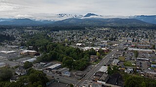
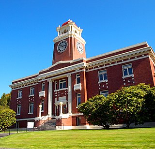
Port Angeles is a city and county seat of Clallam County, Washington, United States. With a population of 19,960 as of the 2020 census, it is the largest city in the county. The population was estimated at 20,134 in 2021.
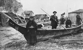
Klallam refers to four related indigenous Native American/First Nations communities from the Pacific Northwest of North America. The Klallam culture is classified ethnographically and linguistically in the Coast Salish subgroup. Two Klallam bands live on the Olympic Peninsula and one on the Kitsap Peninsula in Washington state, and one is based at Becher Bay on southern Vancouver Island in British Columbia.
The Jamestown S'Klallam Tribe is a federally recognized tribe of S'Klallam or Klallam Native Americans. They are on the northern Olympic Peninsula of Washington state in the northwestern United States.

The Dosewallips River is a river situated on the Olympic Peninsula in the U.S. state of Washington. It rises near Mount Anderson in the Olympic Mountains within Olympic National Park and drains to Hood Canal and thence to the Pacific Ocean.

The Elwha River is a 45-mile (72 km) river on the Olympic Peninsula in the U.S. state of Washington. From its source at Elwha snowfinger in the Olympic Mountains, it flows generally north to the Strait of Juan de Fuca. Most of the river's course is within the Olympic National Park.

The Chimakum, also spelled Chemakum and Chimacum Native American people, were a group of Native Americans who lived in the northeastern portion of the Olympic Peninsula in Washington state, between Hood Canal and Discovery Bay until their virtual extinction in 1902. Their primary settlements were on Port Townsend Bay, on the Quimper Peninsula, and Port Ludlow Bay to the south.
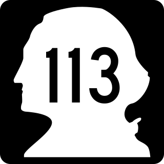
State Route 113 (SR 113), also known as Burnt Mountain Road, is a Washington state highway in Clallam County on the Olympic Peninsula. It connects U.S. Route 101 (US 101) at Sappho to SR 112 near Clallam Bay, traveling north along Beaver Creek and the Pysht River for 10 miles (16 km).

State Route 112 is a state highway and scenic byway in the U.S. state of Washington. It runs east–west for 61 miles (98 km) along the Strait of Juan de Fuca in Clallam County, connecting the Makah Indian Reservation near Neah Bay to U.S. Route 101 (US 101) near Port Angeles.

La Push is a small unincorporated community situated at the mouth of the Quillayute River in Clallam County, Washington, United States, in the western Olympic Peninsula. La Push is the largest community within the Quileute Indian Reservation, which is home to the federally recognized Quileute tribe. La Push is known for its whale-watching and natural environment. The community has historically been located on the coast, however sea level rise led the community to begin managed retreat to higher grounds in 2017.
Clallam Bay is an unincorporated community and census-designated place (CDP) in Clallam County, Washington, United States, at the mouth of the Clallam River into Clallam Bay. Known for its natural environment and hunting, Clallam Bay is partially reliant on tourism. Clallam Bay is considered the twin city of nearby Sekiu. As of the 2010 census, the population of Clallam Bay was 363.

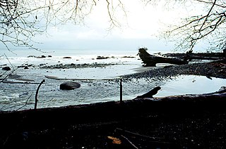
Discovery Bay is a small bay connected to the Strait of Juan de Fuca on the coast of the Olympic Peninsula in Washington state; it was also historically called Port Discovery. An unincorporated community also named Discovery Bay lies in Jefferson County at the southern end of the bay.

Sappho is an unincorporated community in Clallam County, Washington, United States. The town is located at the intersection of U.S. Route 101 and State Route 113, in a largely forested area, and features parks and recreational facilities.
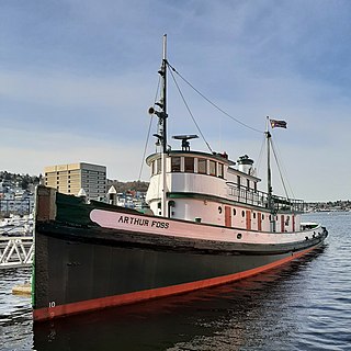
Arthur Foss, built in 1889 as Wallowa at Portland, Oregon, is likely the oldest wooden tugboat afloat in the world. Its 79-year commercial service life began with towing sailing ships over the Columbia River bar, and ended with hauling bundled log rafts on the Strait of Juan de Fuca in 1968. Northwest Seaport now preserves the tug as a museum ship in Seattle, Washington.
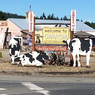
Chimacum is an unincorporated community in Jefferson County, Washington, United States, located in the center of the primary agricultural area of the eastern Olympic Peninsula. It was named after the Chimakum group of Indigenous Americans that lived there until the late 19th century but are now extinct as a distinct cultural group. Chimacum Creek is named after the Chimakum, a Native American people known to themselves as Aqokúlo, who lived on the northeastern portion of the Olympic Peninsula through the mid-19th century and whose economy, culture and religion were based on salmon fishing. Their primary settlements were on Port Townsend Bay, on the Quimper Peninsula, and Port Ludlow Bay to the south. According to tradition, the Chimakum were a remnant of a Quileute band who had been carried away in their canoes by a great flood through a passageway in the Olympic Mountains and deposited on the other side of the peninsula. In 1855 the Twana and Chimakum, along with the Klallam, signed the Point No Point Treaty, which established a reservation at the mouth of the Skokomish River near the southern end of Hood Canal. One of the Chimakum signatories of the treaty was Chief Kulkakhan, also known as General Pierce. After this, most Chimakum people merged into the S’Klallam and Skokomish tribes, where their descendants still live today.

The Lyre River in the U.S. state of Washington flows out of Lake Crescent in the Olympic National Park and into the Strait of Juan de Fuca. Originally referred to as "singing waters" by the Indians living near it, the river was first named Rio de Cuesta by Europeans in 1790 by Gonzalo López de Haro, but was later called River Lyre after being charted by Captain Henry Kellett in 1847.

U.S. Route 101 (US 101) is a United States Numbered Highway that runs along the West Coast from Los Angeles, California to Tumwater, Washington. Within the state of Washington, US 101 connects cities on the coast of the Pacific Ocean and encircles the Olympic Peninsula around the Olympic Mountains. It also serves as the main access for Olympic National Park, several state parks, and other scenic and recreational areas.

The Elwha Ecosystem Restoration Project is a 21st-century project of the U.S. National Park Service to remove two dams on the Elwha River on the Olympic Peninsula in Washington state, and restore the river to a natural state. It is the largest dam removal project in history and the second largest ecosystem restoration project in the history of the National Park Service, after the Restoration of the Everglades. The controversial project, costing about $351.4 million, has been contested and periodically blocked for decades. It has been supported by a major collaboration among the Lower Elwha Klallam Tribe, and federal and state agencies.

The Lower Elwha Klallam Tribe is a federally recognized Native American nation in the Pacific Northwest of the United States. The tribe is part of the larger Klallam culture, part of the Coast Salish people.

