
Moclips is an unincorporated community and census-designated place (CDP) in Grays Harbor County, Washington, United States. The population was 211 at the 2020 census. It is located near the mouth of the Moclips River.

The Quileute are a Native American people in western Washington state in the United States, with 808 enrolled members as of 3/14/2018. They are a federally recognized tribe: the Quileute Tribe of the Quileute Reservation.

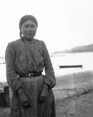
The Quinault are a group of Native American peoples from western Washington in the United States. They are a Southwestern Coast Salish people and are enrolled in the federally recognized Quinault Tribe of the Quinault Reservation.
The Hoh or Chalá·at are a Native American tribe in western Washington state in the United States. The tribe lives on the Pacific Coast of Washington on the Olympic Peninsula. The Hoh moved onto the Hoh Indian Reservation, 47°44′31″N124°25′17″W at the mouth of the Hoh River, on the Pacific Coast of Jefferson County, after the signing of the Quinault Treaty on July 1, 1855. The reservation has a land area of 1.929 square kilometres and a 2000 census resident population of 102 persons, 81 of whom were Native Americans. It lies about halfway between its nearest outside communities of Forks, to its north, and Queets, to its south. The river is central to their culture. The main resources they used included cedar trees, salmon, and the nearby vegetation. They also traded and bartered with other tribes closer to Eastern Washington, near the Plateaus and Great Plains.

The Hoh River is a river of the Pacific Northwest, located on the Olympic Peninsula in the U.S. state of Washington. About 56 miles (90 km) long, the Hoh River originates at the snout of Hoh Glacier on Mount Olympus and flows westward through the Olympic Mountains of Olympic National Park and Olympic National Forest, then through foothills in a broad valley, emptying into the Pacific Ocean at the Hoh Indian Reservation. The final portion of the Hoh River's course marks the boundary between the south coastal segment of Olympic National Park and the Hoh Indian Reservation.

The Bogachiel River is a river of the Olympic Peninsula in the U.S. state of Washington. It originates near Bogachiel Peak, and flows westward through the mountains of Olympic National Park. After emerging from the park it joins the Sol Duc River, forming the Quillayute River, which empties into the Pacific Ocean near La Push, Washington.

The Quillayute River is a river situated on the Olympic Peninsula in Washington. It empties to the Pacific Ocean at La Push, Washington. The Quillayute River is formed by the confluence of the Bogachiel River, Calawah River and the Sol Duc River near the town of Forks, WA. The Dickey River joins the Quillayute from the north, just above the river's mouth at the Pacific Ocean.

The Chimakum, also spelled Chemakum and Chimacum Native American people, were a group of Native Americans who lived in the northeastern portion of the Olympic Peninsula in Washington state, between Hood Canal and Discovery Bay until their virtual extinction in 1902. Their primary settlements were on Port Townsend Bay, on the Quimper Peninsula, and Port Ludlow Bay to the south.

La Push is a small unincorporated community situated at the mouth of the Quillayute River in Clallam County, Washington, United States, in the western Olympic Peninsula. La Push is the largest community within the Quileute Indian Reservation, which is home to the federally recognized Quileute tribe. La Push is known for its whale-watching and natural environment. The community has historically been located on the coast; however, sea level rise led the community to begin managed retreat to higher grounds in 2017.

The Olympic Coast National Marine Sanctuary is one of 15 marine sanctuaries administered by the National Oceanic and Atmospheric Administration (NOAA), an agency of the U.S. Department of Commerce. Declared in 1994, the sanctuary encompasses 3,189 square miles (8,260 km2) of the Pacific Ocean along the Olympic Peninsula of Washington state, from Cape Flattery in the north, to the mouth of the Copalis River, a distance of about 162.5 miles (261.5 km). Extending 25 to 40 miles from the shore, it includes most of the continental shelf, as well as parts of three important submarine canyons, the Nitinat Canyon, the Quinault Canyon and the Juan de Fuca Canyon. For 64 miles (103 km) along the coast, the sanctuary shares stewardship with the Olympic National Park. Sanctuary stewardship is also shared with the Hoh, Quileute, and Makah Tribes, as well as the Quinault Indian Nation. The sanctuary overlays the Flattery Rocks, Quillayute Needles, and Copalis Rock National Wildlife Refuges.

James Island is at the mouth of the Quillayute River near La Push, Washington. Local historians say it is named for Francis Wilcox James, a lighthouse keeper and friend of the Quileute Indians there, though the Origin of Washington Geographic Names attributes the name to Jimmie Howeshatta, a Quileute chief.

Quileute Tribal School (QTS) is a Quileute, Native American school located in La Push, Washington. It is a K-12 school, serving students in grades kindergarten – 12. QTS is affiliated with the Bureau of Indian Education (BIE). It has a compact with the state of Washington and receives a grant from the BIE.
The Quinault Treaty was a treaty agreement between the United States and the Native American Quinault and Quileute tribes located in the western Olympic Peninsula north of Grays Harbor, in the recently formed Washington Territory. The treaty was signed on 1 July 1855, at the Quinault River, and on 25 January 1856 at Olympia, the territorial capital. It was ratified by Congress on 8 March 1859, and proclaimed law on April 11, 1859.

La Push Beach is a series of three beaches near the community of La Push, Washington, on the Pacific coast of the United States. The beach's most prominent natural vegetation the Sitka, spruce, and evergreen trees that populate the shore.
United States v. Mitchell, 463 U.S. 206 (1983), was a case in which the Supreme Court of the United States held that the United States is accountable in money damages for alleged breaches of trust in connection with its management of forest resources on allotted lands of the Quinault Reservation.
The Quinault Indian Nation, formerly known as the Quinault Tribe of the Quinault Reservation, is a federally recognized tribe of Quinault, Queets, Quileute, Hoh, Chehalis, Chinook, and Cowlitz peoples. They are a Southwestern Coast Salish people of indigenous peoples of the Pacific Northwest Coast. Their tribe is located in Washington state on the Pacific coast of the Olympic Peninsula. These peoples are also represented in other tribes in Washington and Oregon.

The Quinault Canyon is a submarine canyon, off Washington state, in Olympic Coast National Marine Sanctuary.
Quileute Canyon is a submarine canyon, off of Washington state, United States.

Quillehuyte County was a Washington Territory county from January 29, 1868, to 1869. It and Ferguson County are the only two counties of the territory that dissolved, although the Washington Territorial Legislature attempted to dissolve Skamania County in January 1865, but was overruled by the United States Congress. Additionally, some Washington counties have been renamed since their formation; Sawamish County was renamed to Mason in 1864 for example.
Washington Maritime National Wildlife Refuge Complex is an administrative grouping of six National Wildlife Refuges in Washington, managed by the United States Fish and Wildlife Service. It includes:


