Related Research Articles

Moclips is an unincorporated community and census-designated place (CDP) in Grays Harbor County, Washington, United States. The population was 207 at the 2010 census. It is located near the mouth of the Moclips River.

Olympic National Park is a United States national park located in the State of Washington, on the Olympic Peninsula. The park has four regions: the Pacific coastline, alpine areas, the west-side temperate rainforest, and the forests of the drier east side. Within the park there are three distinct ecosystems, including subalpine forest and wildflower meadow, temperate forest, and the rugged Pacific coast.
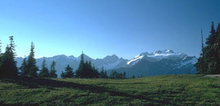
The Olympic Mountains are a mountain range on the Olympic Peninsula of the Pacific Northwest of the United States. The mountains, part of the Pacific Coast Ranges, are not especially high – Mount Olympus is the highest at 7,965 ft (2,428 m); however, the eastern slopes rise out of Puget Sound from sea level and the western slopes are separated from the Pacific Ocean by the low-lying 20 to 35 km wide Pacific Ocean coastal plain. The western slopes are the wettest place in the 48 contiguous states. Most of the mountains are protected within the bounds of Olympic National Park and adjoining segments of the Olympic National Forest.

The Chehalis people or Tsihalis are a native people of western Washington state in the United States. They should not be confused with the similarly named Chehalis First Nation of the Sts'Ailes people along the Harrison River in the Fraser Valley area of British Columbia.
The term Cowlitz people covers two culturally and linguistically distinct indigenous peoples of the Pacific Northwest; the Lower Cowlitz or Cowlitz proper, a southwestern Coast Salish people, which today are enrolled in the federally recognized tribes: Cowlitz Indian Tribe, Quinault Indian Nation, and Confederated Tribes of the Chehalis Reservation; and the Upper Cowlitz / Cowlitz Klickitat or Taitnapam, a Northwest Sahaptin speaking people, part of the Confederated Tribes and Bands of the Yakama Nation.
The Makah are an indigenous people of the Pacific Northwest Coast living in Washington, in the northwestern part of the continental United States. They are enrolled in the federally recognized Makah Indian Tribe of the Makah Indian Reservation.
The Quileute, also known as the Quillayute, are a Native American people in western Washington state in the United States, currently numbering approximately 2,000. They are a federally recognized tribe, Quileute Tribe of the Quileute Reservation
The Quinault are a group of Native American peoples from western Washington in the United States. They are a Southwestern Coast Salish people and are enrolled in the federally recognized Quinault Tribe of the Quinault Reservation.
The Hoh or Chalá·at are a Native American tribe in western Washington state in the United States. The tribe lives on the Pacific Coast of Washington on the Olympic Peninsula. The Hoh moved onto the Hoh Indian Reservation, 47°44′31″N124°25′17″W at the mouth of the Hoh River, on the Pacific Coast of Jefferson County, after the signing of the Quinault Treaty on July 1, 1855. The reservation has a land area of 1.929 square kilometres and a 2000 census resident population of 102 persons, 81 of whom were Native Americans. It lies about half-way between its nearest outside communities of Forks, to its north, and Queets, to its south. The river is central to their culture. The main resources they used included cedar trees, salmon, and the nearby vegetation. They also traded and bartered with other tribes closer to Eastern Washington, near the Plateaus and Great Plains.

The Hoh River is a river of the Pacific Northwest, located on the Olympic Peninsula in the U.S. state of Washington. About 56 miles (90 km) long, the Hoh River originates at the Hoh Glacier on Mount Olympus and flows west through the Olympic Mountains of Olympic National Park and Olympic National Forest, then through the foothills in a broad valley, emptying into the Pacific Ocean at the Hoh Indian Reservation. The final portion of the Hoh River's course marks the boundary between the coastal segment of Olympic National Park and Olympic National Forest, the Hoh Indian Reservation.

The Chimakum, also spelled Chemakum and Chimacum are a near extinct Native American people, who lived in the northeastern portion of the Olympic Peninsula in Washington state, between Hood Canal and Discovery Bay until their virtual extinction in 1902. Their primary settlements were on Port Townsend Bay, on the Quimper Peninsula, and Port Ludlow Bay to the south.

Kalaloch is an unincorporated resort area entirely within Olympic National Park in western Jefferson County, Washington, United States. Kalaloch accommodations are on a 50-foot (15 m) bluff overlooking the Pacific Ocean, west of U.S. Highway 101 on the Olympic Peninsula, north of the reservation of the Quinault Indian Nation.

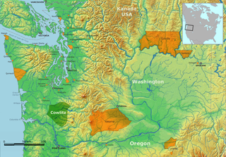
The history of Washington includes thousands of years of Native American history before Europeans arrived and began to establish territorial claims. The region was part of Oregon Territory from 1848 to 1853, after which it was separated from Oregon and established as Washington Territory following the efforts at the Monticello Convention. In 1889, Washington became the 42nd state of the United States.

La Push is a small unincorporated community situated at the mouth of the Quillayute River in Clallam County, Washington, United States. La Push is the largest community within the Quileute Native Reservation, which is home to the federally recognized Quileute tribe. La Push is known for its whale-watching and natural environment.

The Quileute Indian Reservation is an Indian reservation for the Quileute people located on the southwestern Olympic Peninsula in Clallam County, Washington, United States. The reservation is at the mouth of the Quillayute River on the Pacific coast.

The Quinault Indian Nation, formerly known as the Quinault Tribe of the Quinault Reservation, is a federally recognized tribe of Quinault, Queets, Quileute, Hoh, Chehalis, Chinook, and Cowlitz peoples. They are a Southwestern Coast Salish people of indigenous peoples of the Pacific Northwest Coast. Their tribe is located in Washington state on the Pacific coast of the Olympic Peninsula. These peoples are also represented in other tribes in Washington and Oregon.

The Quinault Canyon is a submarine canyon, off Washington state, in Olympic Coast National Marine Sanctuary.
Quileute Canyon is a submarine canyon, off of Washington state, United States.

Quillehuyte County was a Washington Territory county from January 29, 1868 to 1869. It and Ferguson County are the only two counties of the territory that dissolved, although the Washington Territorial Legislature attempted to dissolve Skamania County in January 1865, but was overruled by the United States Congress. Additionally, some Washington counties have been renamed since their formation; Sawamish County was renamed to Mason in 1864 for example.
References
- ↑ "Quinault Treaty". Washington State Historical Society. Archived from the original on 6 May 2009. Retrieved 2 August 2009.
- ↑ "Quinault Treaty, 1856". HistoryLink . Retrieved 2 August 2009.
- ↑ "Clallam County Thumbnail History". HistoryLink . Retrieved 2 August 2009.
- ↑ Prucha, Francis Paul (1994). American Indian Treaties: The History of a Political Anomaly. University of California Press. ISBN 0-520-20895-1.
- 1 2 Interpretation of the Indian Ceded Land Treaties Archived July 20, 2011, at the Wayback Machine , Washington Department of Fish and Wildlife
- ↑ "Jefferson County Thumbnail History". HistoryLink . Retrieved 2 August 2009.