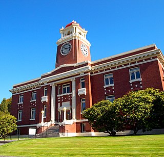
Clallam County is a county in the U.S. state of Washington. As of the 2020 census, the population was 77,155, with an estimated population of 77,805 in 2022. The county seat and largest city is Port Angeles; the county as a whole comprises the Port Angeles, WA Micropolitan Statistical Area. The name is a Klallam word for "the strong people". The county was formed on April 26, 1854. Located on the Olympic Peninsula, it is south from the Strait of Juan de Fuca, which forms the Canada–US border, as British Columbia's Vancouver Island is across the strait.

Neah Bay is a census-designated place (CDP) on the Makah Reservation in Clallam County, Washington, United States. The population was 935 at the 2020 census. It is across the Canada–US border from British Columbia. Europeans originally called it "Scarborough Harbour" in honor of Captain James Scarborough of the Hudson's Bay Company. It was changed to Neah in 1847 by Captain Henry Kellett. Kellett spelled it "Neeah Bay". The name "Neah" refers to the Makah Chief Dee-ah, pronounced Neah in the Klallam language. During the summer months, Neah Bay is a popular fishing area for sports fishermen. Another attraction is the Makah Museum, which houses artifacts from a Makah village partly buried by a mudslide around 1750. Many people also visit to hike the Cape Trail or camp at Hobuck Beach. An emergency response tug is stationed at Neah Bay which has saved 41 vessels since its introduction in 1999.

Olympic National Park is a United States national park located in the State of Washington, on the Olympic Peninsula. The park has four regions: the Pacific coastline, alpine areas, the west-side temperate rainforest, and the forests of the drier east side. Within the park there are three distinct ecosystems, including subalpine forest and wildflower meadow, temperate forest, and the rugged Pacific coast.

The Makah are an Indigenous people of the Pacific Northwest Coast living in Washington, in the northwestern part of the continental United States. They are enrolled in the federally recognized Makah Indian Tribe of the Makah Indian Reservation, commonly known as the Makah Tribe.

The Olympic Peninsula is a large arm of land in western Washington that lies across Puget Sound from Seattle, and contains Olympic National Park. It is bounded on the west by the Pacific Ocean, the north by the Strait of Juan de Fuca, and the east by Hood Canal. Cape Alava, the westernmost point in the contiguous United States, and Cape Flattery, the northwesternmost point, are on the peninsula. Comprising about 3,600 square miles (9,300 km2), the Olympic Peninsula contained many of the last unexplored places in the contiguous United States. It remained largely unmapped until Arthur Dodwell and Theodore Rixon mapped most of its topography and timber resources between 1898 and 1900.

The Chukchi Sea, sometimes referred to as the Chuuk Sea, Chukotsk Sea or the Sea of Chukotsk, is a marginal sea of the Arctic Ocean. It is bounded on the west by the Long Strait, off Wrangel Island, and in the east by Point Barrow, Alaska, beyond which lies the Beaufort Sea. The Bering Strait forms its southernmost limit and connects it to the Bering Sea and the Pacific Ocean. The principal port on the Chukchi Sea is Uelen in Russia. The International Date Line crosses the Chukchi Sea from northwest to southeast. It is displaced eastwards to avoid Wrangel Island as well as the Chukotka Autonomous Okrug on the Russian mainland.

Cape Blanco is a prominent headland on the Pacific Ocean coast of southwestern Oregon in the United States, forming the westernmost point in the state. Cape Blanco extends farther west than any point of land in the contiguous United States except portions of the Olympic Peninsula in Washington, including Cape Alava, the true westernmost point. The cape is part of Cape Blanco State Park and is the location of the Cape Blanco Light, first lit in 1870.

The Columbia Bar is a system of bars and shoals at the mouth of the Columbia River spanning the U.S. states of Oregon and Washington. It is one of the most dangerous bar crossings in the world, earning the nickname Graveyard of the Pacific. The bar is about 3 miles (5 km) wide and 6 miles (10 km) long.

Otokichi, also known as Yamamoto Otokichi and later known as John Matthew Ottoson, was a Japanese castaway originally from the area of Onoura near modern-day Mihama, on the west coast of the Chita Peninsula in Aichi Prefecture.

Cape Mendocino, which is located approximately 200 miles (320 km) north of San Francisco, is located on the Lost Coast entirely within Humboldt County, California, United States. At 124° 24' 34" W longitude, it is the westernmost point on the coast of California. The South Cape Mendocino State Marine Reserve and Sugarloaf Island are immediately offshore, although closed to public access due to their protected status. Sugarloaf Island is cited as California's westernmost island.

Tatoosh Island is a small island and small group of islands about 0.5 miles (0.8 km) offshore (northwest) of Cape Flattery, which is on the northwestern tip of the Olympic Peninsula in Washington. Tatoosh is the largest of a small group of islands also often referred to as simply "Tatoosh Island", which are almost as far west as Cape Alava, which is about 15 miles (24 km) to the south and the westernmost point in the contiguous 48 states. The islands are part of the Makah Reservation and a part of Clallam County. The total land area of the island group is 159,807 square metres.

La Push is a small unincorporated community situated at the mouth of the Quillayute River in Clallam County, Washington, United States, in the western Olympic Peninsula. La Push is the largest community within the Quileute Indian Reservation, which is home to the federally recognized Quileute tribe. La Push is known for its whale-watching and natural environment. The community has historically been located on the coast; however, sea level rise led the community to begin managed retreat to higher grounds in 2017.

The Long Beach Peninsula is an arm of land on the southern coast of the state of Washington in the United States. Entirely within Pacific County, it is bounded on the west by the Pacific Ocean, the south by the Columbia River, and the east by Willapa Bay. Leadbetter Point State Park and Willapa National Wildlife Refuge are at the northern end of the peninsula and Cape Disappointment is at the southern end, with Pacific Pines State Park located in between.

Cape Flattery is the northwesternmost point of the contiguous United States. It is in Clallam County, Washington on the Olympic Peninsula, where the Strait of Juan de Fuca joins the Pacific Ocean. It is also part of the Makah Reservation, and is the northern boundary of the Olympic Coast National Marine Sanctuary. Cape Flattery can be reached from a short hike, most of which is boardwalked. The westernmost point in the contiguous United States is at Cape Alava, south of Cape Flattery in Olympic National Park. However, the westernmost tip of Cape Flattery is almost exactly as far west as Cape Alava, the difference being approximately 5 seconds of longitude, about 360 feet (110 m), at high tide and somewhat more at low tide.

Makah Reservation is an Indian reservation of the Makah Native Americans located on the northwestern tip of the Olympic Peninsula in Clallam County, Washington, United States. The northern boundary of the reservation is the Strait of Juan de Fuca. The western boundary is the Pacific Ocean. It has a land area of 121.451 square kilometres (46.892 sq mi) and a 2000 census resident population of 1,356 persons. Its largest community is Neah Bay.

Lake Ozette is the largest unaltered natural lake in Washington state at 29.5 km2 (11.4 sq mi).
William Henry McNeill was an American marine captain and explorer, best known for his 1830 expedition as the captain of the brig Llama, which sailed from Boston, Massachusetts, United States, 12,000 miles (19,000 km) around Cape Horn, to the Pacific Northwest on a maritime fur trade expedition.
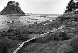
The Ozette Native American Village Archeological Site is the site of an archaeological excavation on the Olympic Peninsula near Neah Bay, Washington, United States. The site was a village occupied by the Ozette Makah people until a mudslide inundated the site around the year 1750. It is located in the now unpopulated Ozette Indian Reservation.
The Peter Roose Homestead is a historic homestead in the U.S. state of Washington that was settled by Peter Roose, an immigrant from Bollnäs, Sweden, in 1907. Located in Olympic National Park, the site was added as a historic district to the National Register of Historic Places in 2007.


