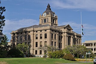
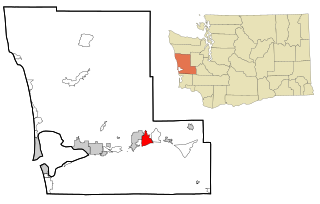
Grays Harbor County is a county in the U.S. state of Washington. As of the 2020 census, the population was 75,636. Its county seat is Montesano, and its largest city is Aberdeen. Grays Harbor County is included in the Aberdeen Micropolitan Statistical Area.
Brady is a census-designated place (CDP) in Grays Harbor County, Washington, United States. The population was 692 at the 2020 census.

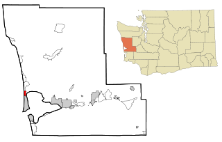
Copalis Beach is a census-designated place (CDP) in Grays Harbor County, Washington, United States. The population was 447 at the 2020 census.

Grayland is a census-designated place (CDP) in Grays Harbor County, Washington, United States. The population was 847 at the 2020 census.

Humptulips is a census-designated place (CDP) in Grays Harbor County, Washington, United States. The population of the CDP was 236 according to the 2020 census.

Moclips is an unincorporated community and census-designated place (CDP) in Grays Harbor County, Washington, United States. The population was 211 at the 2020 census. It is located near the mouth of the Moclips River.

Neilton is an unincorporated community and census-designated place (CDP) in Grays Harbor County, Washington, United States. The population was 299 at the 2020 census, down from 315 at the 2010 census.

Ocean City is a census-designated place (CDP) in Grays Harbor County, Washington, United States. The population was 232 at the 2020 census, up from 200 at the 2010 census.

Ocean Shores is a city in Grays Harbor County, Washington, United States. The population was 6,715 at the 2020 census, and according to 2023 census estimates, the city is estimated to have a population of 7,549.

Satsop is a census-designated place (CDP) in Grays Harbor County, Washington, United States. The population was 675 at the 2010 census, up from 619 at the 2000 census.

Taholah is a unincorporated village on the Quinault Indian Reservation, in Grays Harbor County, Washington, United States. Named for a Quinault chief in 1905, its population was 840 at the 2010 census. For statistical purposes, the United States Census Bureau has defined Taholah as a census-designated place (CDP). The headquarters for the Quinault Indian Nation was moved to Taholah from the town of Quinault on the shore of Lake Quinault.

Pacific Beach is a census-designated place (CDP) in Grays Harbor County, Washington, United States. The population was 280 at the 2020 census, down from 291 at the 2010 census. Prior to 2010 it was part of the Moclips CDP.

Amanda Park is a census designated place on the Olympic Peninsula in Grays Harbor County, Washington, United States, along U.S. Route 101. Olympic National Park and Lake Quinault are directly to the north. As of the 2010 census the population was 252.
Burley is an unincorporated community and census-designated place (CDP) in Kitsap County, Washington, United States. It is located just north of the boundary with Pierce County, about halfway between Gig Harbor to the south and Port Orchard to the north. It is located at the head of the Burley Lagoon in Henderson Bay. Burley is a residential area. The community's population stood at 2,081 at the 2020 census.
Queets is an unincorporated community and census-designated place (CDP) in Grays Harbor and Jefferson counties, Washington, United States. The population was 136 at the 2020 census, down from 174 at the 2010 census. The primary residents of the community are Native Americans of the Quinault Indian Nation.

Malone is an unincorporated community and census-designated place (CDP) in Grays Harbor County, Washington, United States. The population was 468 at the 2020 census. Prior to 2010 it was part of the Malone-Porter CDP; Malone and Porter are now separate CDPs. They are located just off U.S. Route 12, southeast of Elma and northwest of Oakville, and along a shortline that is part of the Puget Sound and Pacific Railroad.
Porter is an unincorporated community and census-designated place (CDP) in Grays Harbor County, Washington, United States. The population was 204 at the 2020 census, slightly down from 207 at the 2010 census. Prior to 2010 it was part of the Malone-Porter CDP; Malone and Porter are now separate CDPs. They are located just off U.S. Route 12, southeast of Elma and northwest of Oakville, and along a shortline that is part of the Puget Sound and Pacific Railroad.
Hogans Corner is a census-designated place (CDP) in Grays Harbor County, Washington, United States. The population was 86 at the 2020 census. Prior to 2010 it was part of the combined Oyehut-Hogan's Corner CDP.
Oyehut is a census-designated place (CDP) in Grays Harbor County, Washington, United States. The population was 79 at the 2020 census, down from 85 at the 2010 census. Prior to 2010 it was part of the combined Oyehut-Hogan's Corner CDP.
Qui-nai-elt Village is a census-designated place (CDP) in Grays Harbor County, Washington, United States. The population was 320 at the 2020 census, significantly up from 54 at the 2010 census.


