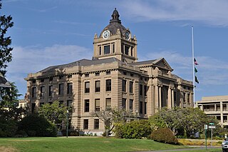
Grays Harbor County is a county in the U.S. state of Washington. As of the 2010 census, the population was 72,797. The county seat is Montesano, and its largest city is Aberdeen.

Brush Prairie is a census-designated place (CDP) in Clark County, Washington, United States. The population was 2,652 at the 2010 census, up from 2,384 at the 2000 census.

Desert Aire is a census-designated place (CDP) in Grant County, Washington, United States. Desert Aire's elevation is 560 ft (170 m). The population was 1,626 at the 2010 census, up from 1,124 at the 2000 census.

Grayland is a census-designated place (CDP) in Grays Harbor County, Washington, United States. The population was 953 at the 2010 census.

Moclips is an unincorporated community and census-designated place (CDP) in Grays Harbor County, Washington, United States. The population was 207 at the 2010 census. It is located near the mouth of the Moclips River.

Neilton is an unincorporated community and census-designated place (CDP) in Grays Harbor County, Washington, United States. The population was 315 at the 2010 census.

Ocean City is a census-designated place (CDP) in Grays Harbor County, Washington, United States. The population was 200 at the 2010 census.

Ocean Shores is a city in Grays Harbor County, Washington, United States. The population was 5,569 at the 2010 census.
Oyehut-Hogans Corner was a census-designated place (CDP) in Grays Harbor County, Washington, United States. The population was 188 at the 2000 census. At the 2010 census Oyehut and Hogans Corner were split into separate CDPs.

Taholah is a census-designated place (CDP) on the Quinault Indian Reservation, in Grays Harbor County, Washington, United States. Named for a Quinault chief in 1905, its population was 840 at the 2010 census. The headquarters for the Quinault Indian Nation was moved to Taholah from the town of Quinault on the shore of Lake Quinault.

Pacific Beach is a census-designated place (CDP) in Grays Harbor County, Washington, United States. The population was 291 at the 2010 census. Prior to 2010 it was part of the Moclips CDP.

Southworth is an unincorporated community and census-designated place (CDP) on Puget Sound in Kitsap County, Washington, United States. It is best known for being the west end of the Fauntleroy-Vashon Island-Southworth Washington State Ferries run. Landmarks include Southworth Grocery, a US Post Office, ferry terminal, clay cliffs and a private beach on the point. Next to the ferry is a popular place to launch kayaks for trips to nearby Blake Island. The population of the Southworth CDP was 2,185 at the 2010 census.

Amanda Park is a census designated place on the Olympic Peninsula in Grays Harbor County, Washington, United States, along U.S. Route 101. Olympic National Park and Lake Quinault are directly to the north. As of the 2010 census the population was 252.
Queets is an unincorporated community and census-designated place (CDP) in Grays Harbor and Jefferson counties, Washington, United States. The population was 174 at the 2010 census. The primary residents of the community are Native Americans of the Quinault Indian Nation.
Malone is an unincorporated community and census-designated place (CDP) in Grays Harbor County, Washington, United States. The population was 475 at the 2010 census. Prior to 2010 it was part of the Malone-Porter CDP; Malone and Porter are now separate CDPs. They are located just off U.S. Route 12, southeast of Elma and northwest of Oakville, and along a shortline that is part of the Puget Sound and Pacific Railroad.
Porter is an unincorporated community and census-designated place (CDP) in Grays Harbor County, Washington, United States. The population was 207 at the 2010 census. Prior to 2010 it was part of the Malone-Porter CDP; Malone and Porter are now separate CDPs. They are located just off U.S. Route 12, southeast of Elma and northwest of Oakville, and along a shortline that is part of the Puget Sound and Pacific Railroad.
Oyehut is a census-designated place (CDP) in Grays Harbor County, Washington, United States. The population was 85 at the 2010 census. Prior to 2010 it was part of the combined Oyehut-Hogan's Corner CDP.
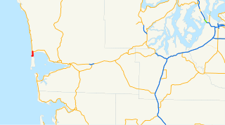
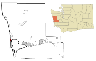
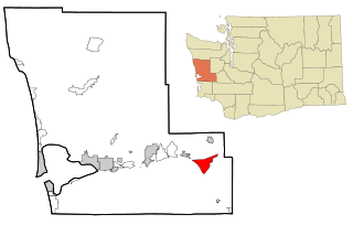
State Route 115 (SR 115) is a 2.28-mile-long (3.67 km) state highway in the U.S. state of Washington serving the city of Ocean Shores in Grays Harbor County. The highway begins at Point Brown Avenue in Ocean Shores and travels east across the peninsula before turning north and ending at SR 109 south of Ocean City at Oyehut-Hogan's Corner. SR 115 was established in 1973 to serve Ocean Shores and follows a road built in the 1950s.
Santiago is a census-designated place (CDP) in Grays Harbor County, Washington, United States. The population was 42 at the 2010 census.
Qui-nai-elt Village is a census-designated place (CDP) in Grays Harbor County, Washington, United States. The population was 54 at the 2010 census.

