Copalis Beach, Washington | |
---|---|
Digging razor clams on the beach, 1915 | |
Location of Copalis Beach, Washington | |
Coordinates: 47°7′4″N124°10′42″W / 47.11778°N 124.17833°W Coordinates: 47°7′4″N124°10′42″W / 47.11778°N 124.17833°W | |
Country | United States |
State | Washington |
County | Grays Harbor |
Area | |
• Total | 3.8 sq mi (9.8 km2) |
• Land | 3.7 sq mi (9.6 km2) |
• Water | 0.1 sq mi (0.3 km2) |
Elevation | 23 ft (7 m) |
Population (2010) | |
• Total | 415 |
• Density | 132.0/sq mi (51.0/km2) |
Time zone | UTC-8 (Pacific (PST)) |
• Summer (DST) | UTC-7 (PDT) |
ZIP code | 98535 |
Area code(s) | 360 |
FIPS code | 53-14660 [1] |
GNIS feature ID | 1530849 [2] |
Copalis Beach is a census-designated place (CDP) in Grays Harbor County, Washington, United States. The population was 415 at the 2010 census.
The name "Copalis" comes from the Quinault language term /k'ʷpíls/. [3] The Copalis are a Native American group. Both the Chehalis people and Quinault Indian Nation claim the Copalis are a subdivision of their tribe. [4]
Copalis Beach is located at 47°7′4″N124°10′42″W / 47.11778°N 124.17833°W (47.117784, -124.178435). [5]
According to the United States Census Bureau, the CDP has a total area of 3.8 square miles (9.8 km2), of which, 3.7 square miles (9.6 km2) of it is land and 0.1 square miles (0.3 km2) of it (2.63%) is water.
Historical population | |||
---|---|---|---|
Census | Pop. | %± | |
2000 | 489 | — | |
2010 | 415 | −15.1% | |
U.S. Decennial Census |
As of the census [1] of 2000, there were 489 people, 232 households, and 135 families residing in the CDP. The population density was 132.0 people per square mile (51.0/km2). There were 484 housing units at an average density of 130.7/sq mi (50.5/km2). The racial makeup of the CDP was 91.00% White, 0.20% African American, 4.70% Native American, 1.43% Asian, and 2.66% from two or more races. Hispanic or Latino of any race were 1.43% of the population.
There were 232 households, out of which 21.1% had children under the age of 18 living with them, 45.7% were married couples living together, 8.6% had a female householder with no husband present, and 41.4% were non-families. 34.5% of all households were made up of individuals, and 15.9% had someone living alone who was 65 years of age or older. The average household size was 2.11 and the average family size was 2.67.
In the CDP, the population was spread out, with 19.6% under the age of 18, 4.7% from 18 to 24, 20.0% from 25 to 44, 32.1% from 45 to 64, and 23.5% who were 65 years of age or older. The median age was 49 years. For every 100 females, there were 90.3 males. For every 100 females age 18 and over, there were 89.9 males.
The median income for a household in the CDP was $33,194, and the median income for a family was $33,807. Males had a median income of $45,694 versus $20,156 for females. The per capita income for the CDP was $17,437. About 17.3% of families and 17.4% of the population were below the poverty line, including 37.9% of those under age 18 and 16.3% of those age 65 or over.
The Copalis Native Americans belong to the coastal division of the Salishan language family and historically occupied the area of Copalis River and the Pacific Coast between the mouth of Joe Creek and Grays Harbor. In 1805, Lewis and Clark estimated a population of 200 Copalis in 10 houses. The 5 individuals assigned to a "Chepalis" tribe in an enumeration given by Olson of the year 1888 probably refers to them.
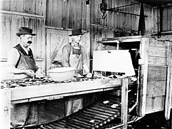
The first non-Native American people settled in Copalis Beach in the 1890s. Copalis, along with the beach of the same name, has become famed as the "Home of the razor clam." The community sits near the northern end of probably the greatest razor clam bed in the world[ citation needed ] for the flavor renowned variety abounds, apparently only in the Pacific Northwest, and particularly on Copalis Beach. During the commercial season, Copalis' normal population of about 350 persons, leaped fourfold.
During 1947 and 1948, commercial diggers took more than a million pounds of bivalves from Copalis Beach, earned themselves approximately $200,000.00 and brought huge additional sums to cannery men and workers.[ citation needed ] Tourists dug thousands of pounds more.
Grays Harbor County is a county in the U.S. state of Washington. As of the 2010 census, the population was 72,797. The county seat is Montesano, and its largest city is Aberdeen. Grays Harbor County is included in the Aberdeen Micropolitan Statistical Area.
Clam Gulch is a census-designated place (CDP) in Kenai Peninsula Borough, Alaska, United States. At the 2010 census the population was 176.
Vilano Beach is an unincorporated community in St. Johns County, Florida, United States. It is listed as the Villano Beach census-designated place (CDP) by the U.S. Census Bureau. The population was 2,678 at the 2010 census.
Wilmington Island is a census-designated place (CDP) in Chatham County, Georgia, United States. The population was 15,138 at the 2010 census. It is part of the Savannah, Georgia Metropolitan Statistical Area. The communities of Wilmington Island form a large and affluent suburb of Savannah, where most residents work. The island lies east of Savannah between the town of Thunderbolt and the beach community of Tybee Island.
Ravalli is an unincorporated community and census-designated place (CDP) in Lake County, Montana, United States. The population was 76 at the 2010 census, down from 119 in 2000. At one time Charlie Allard, the country's leading expert on breeding bison, owned the country's largest herd of buffalo in Ravalli.
White Plains is a census-designated place (CDP) in Surry County, North Carolina, United States. The population was 1,049 at the 2000 census.
South Canal is a census-designated place (CDP) in Trumbull County, Ohio, United States. The population was 1,346 at the 2000 census. It is part of the Youngstown–Warren–Boardman, OH-PA Metropolitan Statistical Area.
Brushy is a census-designated place (CDP) in Sequoyah County, Oklahoma, United States, along U.S. Route 59 in the foothills of the Brushy Mountains. It is part of the Fort Smith, Arkansas-Oklahoma Metropolitan Statistical Area. The population was 900 at the 2010 census, an increase of 14.4 percent over the figure of 787 recorded in 2000.
Lincoln Beach is a census-designated place (CDP) in Lincoln County, Oregon, United States. It includes the unincorporated communities of Lincoln Beach and Gleneden Beach. The total population was 2,045 at the 2010 census.
Neskowin is an unincorporated community in Tillamook County, Oregon, United States, along the Pacific Ocean between Cascade Head and Nestucca Bay. For statistical purposes, the United States Census Bureau has defined Neskowin as a census-designated place (CDP). The census definition of the area may not precisely correspond to local understanding of the area with the same name. The population of the CDP was 134 at the 2010 census, a decrease from 169 at the 2000 census.
Cohassett Beach is a census-designated place (CDP) in Grays Harbor County, Washington, United States. The population was 722 at the 2010 census.
Grayland is a census-designated place (CDP) in Grays Harbor County, Washington, United States. The population was 953 at the 2010 census.
Moclips is an unincorporated community and census-designated place (CDP) in Grays Harbor County, Washington, United States. The population was 207 at the 2010 census. It is located near the mouth of the Moclips River.
Neilton is an unincorporated community and census-designated place (CDP) in Grays Harbor County, Washington, United States. The population was 315 at the 2010 census.
Ocean City is a census-designated place (CDP) in Grays Harbor County, Washington, United States. The population was 200 at the 2010 census.
Oyehut-Hogans Corner was a census-designated place (CDP) in Grays Harbor County, Washington, United States. The population was 188 at the 2000 census. At the 2010 census Oyehut and Hogans Corner were split into separate CDPs.
Taholah is a census-designated place (CDP) on the Quinault Indian Reservation, in Grays Harbor County, Washington, United States. Named for a Quinault chief in 1905, its population was 840 at the 2010 census. The headquarters for the Quinault Indian Nation was moved to Taholah from the town of Quinault on the shore of Lake Quinault.
Lake Marcel-Stillwater is a census-designated place (CDP) in King County, Washington, United States. The population was 1,277 at the 2010 census.
Easton is an unincorporated community and census-designated place (CDP) in Kittitas County, Washington, United States. The population was 478 at the 2010 census.
North Sultan is a census-designated place (CDP) in Snohomish County, Washington, United States. The population was 264 at the 2010 census.