Bret Harte is a census-designated place (CDP) in Stanislaus County, California, United States. The population was 5,152 at the 2010 census, down from 5,161 at the 2000 census. It is part of the Modesto Metropolitan Statistical Area. It is named for the American poet and short story writer, Bret Harte, best known for his writings about the California Gold Rush.

Wye is an unincorporated community and census-designated place in Missoula County, Montana, United States. It is part of the Missoula metropolitan area. The population was 714 at the 2020 census, up from 511 in 2010. The community is named for the "y"-shaped DeSmet Junction where US 93 and MT 200 met former US 10.

Peralta is a town in Valencia County, New Mexico, United States. Prior to its incorporation on July 1, 2007, it was a census-designated place (CDP). The population was 3,660 as of the 2010 census. Peralta is part of the Albuquerque metropolitan area.

Forest Home is a census-designated place (CDP) in the town of Ithaca, New York, United States. The population was 572 at the 2010 census. It is located immediately east of the Cornell University campus.

Moses Lake North is a census-designated place (CDP) in Grant County, Washington, United States. It is also included in the Moses Lake micropolitan area. The population was 4,050 at the 2020 census.

Aberdeen Gardens is a census-designated place (CDP) in Grays Harbor County, Washington, United States. The population was 279 at the 2010 census.
Brady is a census-designated place (CDP) in Grays Harbor County, Washington, United States. The population was 692 at the 2020 census.

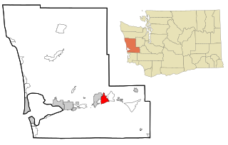
Central Park is a census-designated place (CDP) in Grays Harbor County, Washington, United States. The population was 2,841 at the 2020 census.
Chehalis Village is a former census-designated place (CDP) in Grays Harbor County, Washington, United States. The population was 346 at the 2000 census. The area was no longer listed as a CDP for the 2010 census.

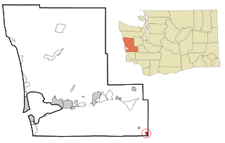
Junction City is a census-designated place (CDP) in Grays Harbor County, Washington, United States. The population was 18 at the 2010 census.

Markham is a census-designated place (CDP) in Grays Harbor County, Washington, United States. The population was 119 at the 2020 census.

Neilton is an unincorporated community and census-designated place (CDP) in Grays Harbor County, Washington, United States. The population was 299 at the 2020 census, down from 315 at the 2010 census.
Hobart is an unincorporated community and census-designated place (CDP) in King County, Washington, United States. The population was 6,767 at the 2020 census.

Lakeland South is a census-designated place (CDP) in King County, Washington, United States. The population was 13,169 at the 2020 census.

Parkwood is a census-designated place (CDP) in Kitsap County, Washington, United States. The population was 7,635 at the 2020 census.

Bay Center is a census-designated place (CDP) in Pacific County, Washington, United States. The population was 174 at the 2000 census. The population increased to 276 at the 2010 census. However, in the 2020 census, the population decreased to 253.

High Bridge is a census-designated place (CDP) in Snohomish County, Washington, United States. The population was 3,140 at the 2020 census, up from 2,994 at the 2010 census. High Bridge includes the Echo Lake community and the former Echo Lake CDP, which was superseded by the larger High Bridge CDP in 2010.

Lake Stickney is a census-designated place (CDP) in Snohomish County, Washington, United States. The population was 15,413 at the 2020 census. The CDP was known as Paine Field-Lake Stickney prior to 2010. The new Lake Stickney CDP no longer contains the Paine Field airport.

Greenacres is a locale and former census-designated place (CDP) in Spokane County, Washington, United States. The locale is almost entirely split between the city of Spokane Valley and unincorporated Spokane County, with a small portion being located within the city of Liberty Lake. Greenacres retains its own post office.
Anson is a census-designated place (CDP) in the town of Anson in Somerset County, Maine, United States. The population was 818 at the 2000 census.


