Central Park, Washington

Last updated
Central Park, Washington
CDP
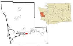
Grays Harbor County Washington Incorporated and Unincorporated areas Central Park Highlighted.svg
Location of Central Park, Washington
Coordinates: 46°58′8″N123°42′33″W / 46.96889°N 123.70917°W / 46.96889; -123.70917 Coordinates: 46°58′8″N123°42′33″W / 46.96889°N 123.70917°W / 46.96889; -123.70917
CountryUnited States
State Washington
County Grays Harbor
Area
  Total3.5 sq mi (9.1 km2)
  Land3.5 sq mi (9.1 km2)
  Water0.0 sq mi (0.0 km2)
Elevation
138 ft (42 m)
Population
 (2020)
  Total2,841
  Density728.8/sq mi (281.4/km2)
Time zone UTC-8 (Pacific (PST))
  Summer (DST) UTC-7 (PDT)
ZIP code
98520
Area code(s) 360
FIPS code 53-11195 [1]
GNIS feature ID1512077 [2]

Central Park is a census-designated place (CDP) in Grays Harbor County, Washington, United States. The population was 2,841 at the 2020 census. [3]

Contents

Geography

Central Park is located at 46°58′8″N123°42′33″W / 46.96889°N 123.70917°W / 46.96889; -123.70917 (46.968877, -123.709163). [4]

According to the United States Census Bureau, the CDP has a total area of 3.5 square miles (9.1 km2), all of it land.

Demographics

Historical population
CensusPop.
1960 1,622
1970 2,72067.7%
1980 2,709−0.4%
1990 2,669−1.5%
2000 2,558−4.2%
2010 2,6855.0%
2020 2,8415.8%
U.S. Decennial Census [5]
2020 Census [3]

As of the census [1] of 2000, there were 2,558 people, 1,037 households, and 779 families residing in the CDP. The population density was 728.8 people per square mile (281.4/km2). There were 1,092 housing units at an average density of 311.1/sq mi (120.1/km2). The racial makeup of the CDP was 93.86% White, 0.08% African American, 1.25% Native American, 1.21% Asian, 0.08% Pacific Islander, 0.51% from other races, and 3.01% from two or more races. Hispanic or Latino of any race were 1.80% of the population.

There were 1,037 households, out of which 29.7% had children under the age of 18 living with them, 64.4% were married couples living together, 7.7% had a female householder with no husband present, and 24.8% were non-families. 21.4% of all households were made up of individuals, and 10.6% had someone living alone who was 65 years of age or older. The average household size was 2.47 and the average family size was 2.83.

In the CDP, the population was spread out, with 23.2% under the age of 18, 5.4% from 18 to 24, 23.9% from 25 to 44, 29.4% from 45 to 64, and 18.1% who were 65 years of age or older. The median age was 44 years. For every 100 females, there were 98.8 males. For every 100 females age 18 and over, there were 98.6 males.

The median income for a household in the CDP was $45,719, and the median income for a family was $50,313. Males had a median income of $41,081 versus $30,208 for females. The per capita income for the CDP was $21,003. About 6.4% of families and 7.3% of the population were below the poverty line, including 5.8% of those under age 18 and 9.7% of those age 65 or over.

Related Research Articles

Fort Greely, Alaska CDP in Alaska, United States

Fort Greely is a census-designated place (CDP) in Southeast Fairbanks Census Area, Alaska, United States. It is home to the Fort Greely military installation. At the 2010 census the population was 539, up from 461 in 2000.

Jeddito, Arizona CDP in Navajo County, Arizona

Jeddito is a census-designated place (CDP) in Navajo County, Arizona, United States. The population was 293 at the 2010 census.

Stearns, Kentucky CDP in Kentucky, United States

Stearns is a census-designated place (CDP) in McCreary County, Kentucky, United States. The population was 1,586 at the 2000 census. It was founded by Justus Smith Stearns.

Wye, Montana CDP in Montana, United States

Wye is a census-designated place (CDP) in Missoula County, Montana, United States. It is part of the Missoula, Montana Metropolitan Statistical Area. The population was 511 at the 2010 census, an increase from its population of 381 in 2000. Wye is named for the "y"-shaped DeSmet Junction where US 93 and MT 200 met former US 10.

Hebo, Oregon Census-designated place in Oregon, United States

Hebo is an unincorporated community in Tillamook County, Oregon, United States. For statistical purposes, the United States Census Bureau has defined Hebo as a census-designated place (CDP). The census definition of the area may not precisely correspond to local understanding of the area with the same name. The population of the CDP was 231 at the 2000 census.

Neskowin, Oregon Census-designated place in Oregon, United States

Neskowin is an unincorporated community in Tillamook County, Oregon, United States, along the Pacific Ocean between Cascade Head and Nestucca Bay. For statistical purposes, the United States Census Bureau has defined Neskowin as a census-designated place (CDP). The census definition of the area may not precisely correspond to local understanding of the area with the same name. The population of the CDP was 134 at the 2010 census, a decrease from 169 at the 2000 census.

Reinerton-Orwin-Muir, Pennsylvania Former CDP in Pennsylvania, United States

Reinerton-Orwin-Muir was a census-designated place (CDP) in Schuylkill County, Pennsylvania, United States. The population was 1,037 at the 2000 census. For the 2010 census the area was split into three CDPs, Reinerton, Orwin, and Muir.

Sheffield, Pennsylvania Census-designated place in Pennsylvania, United States

Sheffield is a census-designated place (CDP) in within Sheffield Township in southeastern Warren County, Pennsylvania, United States. It is named after Sheffield, England. The population was 1,123 at the 2010 census.

River Road, Washington Census-designated place in Washington, United States

River Road is a census-designated place (CDP) in Clallam County, Washington, United States. The population was 454 at the 2010 census. It is a primarily residential area next to the city of Sequim.

Aberdeen Gardens, Washington CDP in Washington, United States

Aberdeen Gardens is a census-designated place (CDP) in Grays Harbor County, Washington, United States. The population was 279 at the 2010 census.

Chehalis Village, Washington Former CDP in Washington, United States

Chehalis Village is a former census-designated place (CDP) in Grays Harbor County, Washington, United States. The population was 346 at the 2000 census. The area was no longer listed as a CDP for the 2010 census.

Junction City, Washington Census-designated place in Washington, United States

Junction City is a census-designated place (CDP) in Grays Harbor County, Washington, United States. The population was 18 at the 2010 census.

Markham, Washington CDP in Washington, United States

Markham is a census-designated place (CDP) in Grays Harbor County, Washington, United States. The population was 111 at the 2010 census.

Skokomish, Washington CDP in Washington, United States

Skokomish is a census-designated place (CDP) in Mason County, Washington, United States. The population was 617 at the 2010 census. The town is the headquarters of the Skokomish Indian Tribe.

Bay Center, Washington CDP in Washington, United States

Bay Center is a census-designated place (CDP) in Pacific County, Washington, United States. The population was 174 at the 2000 census. The population increased to 276 at the 2010 census.

Lebam, Washington CDP in Washington, United States

Lebam is a census-designated place (CDP) in Pacific County, Washington, United States. The population was 160 at the 2010 census.

Tokeland, Washington CDP in Washington, United States

Tokeland is a census-designated place (CDP) in Pacific County, Washington, United States. The population was 151 at the 2010 census, a sharp decrease from the 194 at the 2000 census.

Oak Hill, Maine Census-designated place in Maine, United States

Oak Hill is a census-designated place (CDP) in the town of Scarborough in Cumberland County, Maine, United States. Prior to the 2020 census, the CDP was known as Scarborough. The population was 4,403 at the 2010 census. It is part of the Portland–South Portland–Biddeford, Maine Metropolitan Statistical Area.

Chatham (CDP), Massachusetts Census-designated place in Massachusetts, United States

Chatham is a census-designated place (CDP) in the town of Chatham in Barnstable County, Massachusetts, United States. The population was 1,421 at the 2010 census, out of 6,125 in the entire town of Chatham.

Morgan Farm, Texas CDP in Texas, United States

Morgan Farm is a census-designated place (CDP) in San Patricio County, Texas, United States. The population was 463 at the 2010 census. Prior to the 2010 census Morgan Farm CDP was known as Morgan Farm Area CDP.

References

  1. 1 2 "U.S. Census website". United States Census Bureau . Retrieved January 31, 2008.
  2. "Central Park". Geographic Names Information System . United States Geological Survey.
  3. 1 2 "2020 Census Redistricting Data (Public Law 94-171) Summary File". American FactFinder. United States Census Bureau . Retrieved March 15, 2022.
  4. "US Gazetteer files: 2010, 2000, and 1990". United States Census Bureau. February 12, 2011. Retrieved April 23, 2011.
  5. "U.S. Decennial Census". Census.gov. Retrieved June 6, 2013.