James Island (La Push, Washington)

Last updated
James Island as seen from First Beach at La Push James-Island.jpg
James Island as seen from First Beach at La Push
James Islands seen from Rialto Beach James Islands seen from Rialto Beach.jpg
James Islands seen from Rialto Beach
After sunset, with Venus visible in the sky, and red and green harbor channel markers visible at the entrance to the Quillayute River James Island Quillayute River harbor lights.jpg
After sunset, with Venus visible in the sky, and red and green harbor channel markers visible at the entrance to the Quillayute River

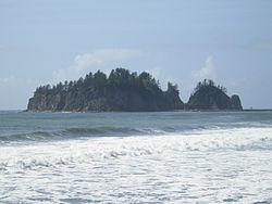
James Island (Quileute: A-ka-lat - "Top of the Rock") is at the mouth of the Quillayute River near La Push, Washington. Local historians say it is named for Francis Wilcox James, a lighthouse keeper and friend of the Quileute Indians there, [1] though the Origin of Washington Geographic Names attributes the name to Jimmie Howeshatta, a Quileute chief. [2] [3]

A fortified village was on the island until the second half of the 19th century. After this it was farmed by mainland residents and tribal chiefs were buried there. At 160 feet (49 m) in height, the island has also been a lookout to spot whales. The island was once a sea stack, connected to the mainland. The US Army Corps of Engineers separated it by rerouting the Quillayute River. Today, the US Coast Guard operates an automated lighthouse and foghorn for boats using the harbor.

In 1966, James Island was removed from the Quillayute Needles National Wildlife Refuge by the U.S. Department of the Interior. The Interior Department returned the island to the Quileute people because it was in the historic Quileute Indian Reservation. [4] No people outside of the Quileute tribe are allowed on the island.

Related Research Articles

Forks, Washington City in Washington, United States

Forks, also previously known as the unincorporated town of Quillayute, is a city in southwest Clallam County, Washington, United States. The population was 3,558 at the 2010 census. At an 2018 estimate from the Office of Financial Management, the population was 3,862. It is named after the forks in the nearby Quillayute, Bogachiel, Calawah, and Sol Duc rivers.

The Quileute, also known as the Quillayute, are a Native American people in western Washington state in the United States, currently numbering approximately 2,000. They are federally recognized tribe, Quileute Tribe of the Quileute Reservation

Quinault people Native American peoples

The Quinault are a group of Native American peoples from western Washington in the United States. They are a Southwestern Coast Salish people and are enrolled in the federally recognized Quinault Tribe of the Quinault Reservation.

The Hoh or Chalá·at are a Native American tribe in western Washington state in the United States. The tribe lives on the Pacific Coast of Washington on the Olympic Peninsula. The Hoh moved onto the Hoh Indian Reservation, 47°44′31″N124°25′17″W at the mouth of the Hoh River, on the Pacific Coast of Jefferson County, after the signing of the Quinault Treaty on July 1, 1855. The reservation has a land area of 1.929 square kilometres and a 2000 census resident population of 102 persons, 81 of whom were Native Americans. It lies about half-way between its nearest outside communities of Forks, to its north, and Queets, to its south.

Olympic Peninsula peninsula

The Olympic Peninsula is the large arm of land in western Washington that lies across Puget Sound from Seattle, and contains Olympic National Park. It is bounded on the west by the Pacific Ocean, the north by the Strait of Juan de Fuca, and the east by Hood Canal. Cape Alava, the westernmost point in the contiguous United States, and Cape Flattery, the northwesternmost point, are on the peninsula. Comprising about 3600 square miles, the Olympic Peninsula contained many of the last unexplored places in the Contiguous United States. It remained largely unmapped until Arthur Dodwell and Theodore Rixon mapped most of its topography and timber resources between 1898 and 1900.

Bogachiel River river in the United States of America

The Bogachiel River is a river of the Olympic Peninsula in the U.S. state of Washington. It originates near Bogachiel Peak, flows west through the mountains of Olympic National Park. After emerging from the park it joins the Sol Duc River, forming the Quillayute River, which empties into the Pacific Ocean near La Push, Washington.

Quillayute River river in the United States of America

The Quillayute River is a river situated on the Olympic Peninsula in Washington. It empties to the Pacific Ocean at La Push, Washington. The Quillayute River is formed by the confluence of the Bogachiel River, Calawah and the Sol Duc River. The Dickey River joins the Quillayute just above the river's mouth on the Pacific Ocean.

Chimakuan languages language family

The Chimakuan language family consists of one extinct and one severely endangered language spoken in northwestern Washington state, United States, on the Olympic Peninsula. It is part of the Mosan sprachbund, and one of its languages is famous for having no nasal consonants. The two languages were about as close as English and German.

Chimakum

The Chimakum, also spelled Chemakum and Chimacum are a near extinct Native American people, who lived in the northeastern portion of the Olympic Peninsula in Washington State, between Hood Canal and Discovery Bay until their virtual extinction in 1902. Their primary settlements were on Port Townsend Bay, on the Quimper Peninsula, and Port Ludlow Bay to the south.

La Push, Washington Unincorporated community in Washington, United States

La Push is a small unincorporated community situated at the mouth of the Quillayute River in Clallam County, Washington, United States. La Push is the largest community within the Quileute Indian Reservation, which is home to the federally recognized Quileute tribe. La Push is known for its whale-watching and natural environment.

Destruction Island island in the United States of America

Destruction Island is a 30-acre (12 ha) island located approximately 3.5 miles (6 km) off the Washington coast. Home to seabirds, shorebirds, and marine mammals, it is part of the Quillayute Needles National Wildlife Refuge.

Quileute, also known as Quillayute, was the last Chimakuan language, spoken until the end of the 20th century by Quileute and Makah elders on the western coast of the Olympic peninsula south of Cape Flattery at La Push and the lower Hoh River in Washington State, United States. The name Quileute comes from kʷoʔlí·yot’[kʷoʔléːjotʼ], the name of a village at La Push.

Quileute Tribal School (QTS) is a Quileute, Native American school located in La Push, Washington. It is a K-12 school, serving students in grades kindergarten – 12. QTS is part of the Quillayute Valley School District. The school was founded in 1971. The school is accredited by AdvancED.

Dickey River river in the United States of America

The Dickey River is a stream on the Olympic Peninsula in the U.S. state of Washington. It has three main forks, the East Fork, West Fork, and Middle Fork Dickey Rivers. The main stem is formed by the confluence of the East and West Forks. The river and its forks rise in the northwestern part of the Olympic Peninsula and flow generally south and west to join the Quillayute River near its mouth on the Pacific Ocean.

Quileute Indian Reservation reservation in Washington State, USA

The Quileute Indian Reservation is an Indian reservation for the Quileute people located in the southwestern of the Olympic Peninsula in Clallam County, Washington, United States. The reservation is mouth of the Quillayute River on the Pacific coast.

La Push Beach Place in Washington, United States of America

La Push Beach is a series of three beaches near the community of La Push, Washington, on the Pacific coast of the United States. The beach's most prominent natural vegetation the Sitka, spruce, and evergreen trees that populate the shore.

Rialto Beach

Rialto Beach is a public beach located on the Pacific Ocean in Washington state. It is adjacent to Mora Campground in the Olympic National Park near the mouth of the Quillayute River, and is composed of an ocean beach and coastal forest. The many miles of seaside topography offer views of sea stacks and rock formations in the Pacific Ocean.

Quileute Canyon is a submarine canyon, off of Washington State, United States.

Quillehuyte County, Washington former county in Washington Territory, United States (1868-1869)

Quillehuyte County was one of the Washington Territory's counties from January 29, 1868 until 1869. It and Ferguson County are the only two counties of the territory to have become extinct, although the Washington Territorial Legislature attempted to dissolve Skamania County in January 1865, but was overruled by the United States Congress. Additionally, some Washington counties have been renamed since their formation; Sawamish County was renamed to Mason in 1864 for example.

Washington Maritime National Wildlife Refuge Complex is an administrative grouping of six National Wildlife Refuges in Washington, managed by the United States Fish and Wildlife Service. It includes:

References

  1. "A survey of Port Townsend's Ghost Signs & Murals" (PDF). Jefferson County Historical Society. Retrieved 14 July 2018. Francis Wilcox James, a native of England, arrived in Port Townsend in 1853. In 1855 he went to La Push as an Indian Agent and Assistant Lighthouse Keeper at Cape Flattery. While at La Push he became wellliked by the Quileute Indians and, as an honoring gesture, they named James Island after him.
  2. Meany, Edmond S. (1923). Origin of Washington Geographic Names. University of Washington Press. p. 122. Retrieved 14 July 2018. JAMES ISLAND, a small island a little south of the mouth of the Quillayute River, in the southwestern part of Clallam County. It was named in honor of Chief Jimmy of the Quillayute Indians. (Fannie Taylor, Mora, in Names MSS., Letter 807.)
  3. Majors, Harry M. (1975). Exploring Washington. Van Winkle Publishing Co. p. 64. ISBN   978-0-918664-00-6.
  4. Removed by Public Land Order 4095, September 19, 1966, according to Comprehensive Conservation Plan/Environmental Assessment, Chapter 1, page 1-8.

Coordinates: 47°54′20.72″N124°38′52.04″W / 47.9057556°N 124.6477889°W / 47.9057556; -124.6477889