
Cape Hatteras Light is a lighthouse located on Hatteras Island in the Outer Banks in the town of Buxton, North Carolina and is part of the Cape Hatteras National Seashore. The lighthouse’s semi-unique pattern makes it easy to recognize and famous. It is often ranked high on lists of most beautiful, and famous lighthouses in the US.
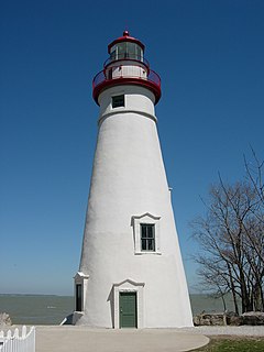
Marblehead Lighthouse in Marblehead, Ohio, United States, is the oldest lighthouse in continuous operation on the American side of the Great Lakes. It has guided sailors safely along the rocky shores of Marblehead Peninsula since 1822, and is an active aid to navigation.

The Toledo Harbor Lighthouse is a lighthouse in Lake Erie near Toledo, Ohio, in the United States. The light replaced the 1837 lighthouse on Turtle Island at the mouth of the Maumee River. It is an active aid to navigation.

Goat Island Light is a lighthouse located off Cape Porpoise near Kennebunkport in southern Maine. Goat Island Light was established in 1835 to guard the entrance to Cape Porpoise Harbor. The original station was upgraded in 1859 to the current brick tower with a fifth order Fresnel lens. Keeper's quarters were added to the island in 1860. The light station was automated by the United States Coast Guard in 1990 and is currently active. The keepers dwellings and tower are leased to the Kennebunkport Conservation Trust. Goat Island Light can be seen from shore in Cape Porpoise Harbor just off State Route 9 north of Kennebunkport or is viewable by boat. The island is currently closed to the public except by special arrangement.

Boston Light is a lighthouse located on Little Brewster Island in outer Boston Harbor, Massachusetts. The first lighthouse to be built on the site dates back to 1716, and was the first lighthouse to be built in what is now the United States. The current lighthouse dates from 1783, is the second oldest working lighthouse in the United States, and is the only lighthouse to still be actively staffed by the United States Coast Guard, being automated in 1998 though there is still a keeper acting as tour guide. The structure was designated a National Historic Landmark in 1964.

Brant Point Light is a lighthouse located on Nantucket Island. The station was established in 1746, automated in 1965, and is still in operation. The current tower was added to the National Register of Historic Places on October 28, 1987; it has the distinction of being the tenth light on the point, in addition to several range lights. Four of the others burned or blew down, two were condemned, two were unsatisfactory, and the remaining one stands unused.

The Browns Point Lighthouse is a lighthouse located near Tacoma on Browns Point at the east entrance to Puget Sound's Commencement Bay, Pierce County, Washington.

The Dofflemyer Point Lighthouse is a U.S. lighthouse in Boston Harbor, Washington, and was one of the first in the state of Washington to be automated. It sits at the northeastern entrance to Budd Inlet north of Olympia. It is the southernmost light in Puget Sound and is listed on the National Register of Historic Places.

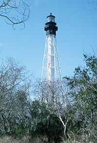
Morris Island Light is a lighthouse on Morris Island in South Carolina. The light stands on the southern side of the entrance to Charleston Harbor, north of the City of Folly Beach. At 161 ft, it is the tallest lighthouse in South Carolina. The lighthouse was named to the National Register of Historic Places in 1982.

The first Saginaw River lighthouse was constructed from 1839 to 1841, in a period when large quantities of lumber were being harvested and shipped from the heart of Michigan via river and the Great Lakes to the East Coast of the United States via the Erie Canal and Hudson River. This connection to major eastern markets was critical to the development of central Michigan.
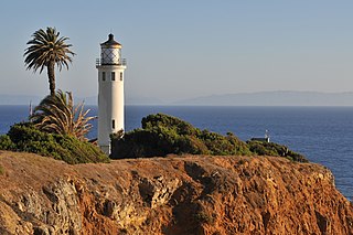
Point Vicente Lighthouse is a lighthouse in Rancho Palos Verdes, California, United States, north of Los Angeles Harbor. It is 67 feet (20 m) tall and stands on a cliff with a height of 130 feet (40 m). It is between Point Loma Lighthouse to the south and Point Conception Lighthouse to the north. The lighthouse was added to the National Register of Historic Places in 1980. The lighthouse is owned by the United States federal government and is managed by the United States Coast Guard. It is not usually open to the public, but the Coast Guard Auxiliary run tours once per month and it is used annually for the city's "Whale of a Day" festival.
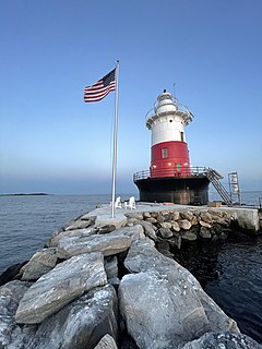
Greens Ledge Lighthouse is a historic offshore lighthouse in the western Long Island Sound near Norwalk, Connecticut and Darien, Connecticut. It is one of 33 sparkplug lighthouses still in existence in the United States and remains an active aid to navigation. It sits in ten feet of water on the west end of Greens Ledge, a shallow underwater reef that runs a mile west of Sheffield Island and is roughly a mile south of the entrance to Five Mile River at Rowayton. Completed in 1902 by the Philadelphia Construction Company, the cast-iron structure is approximately 90 feet tall including roughly 15 feet of the submerged caisson. In 1933, more than 30,000 tons of rocks from the excavation of Radio City Music Hall were added to the riprap foundation. The light was added to the National Register of Historic Places as Greens Ledge Lighthouse on May 29, 1990.
Cape Charles Lighthouse is an octagonal cast iron skeleton tower lighthouse at the mouth of the Chesapeake Bay on Smith Island which was officially removed from service in 2019. It is the tallest lighthouse in Virginia and the second tallest in the United States. This particular tower is the third lighthouse at this location. The first lighthouse at Cape Charles was a 55-foot (17 m) masonry tower completed in 1828. It was quickly deemed inadequate for its important seacoast location due to its low height and poor visibility at sea. It was soon threatened by erosion so in 1864 it was replaced by a 150-foot (46 m) masonry tower built further inland. Located a little more than a mile southwest of the old tower and 600 feet from the shoreline, the impressive 150-foot-tall conical brick tower was similar in appearance to the 1857 Cape May Lighthouse, painted white and topped with a dark brown lantern room. In 1892, a twenty-five-foot red band was painted around the white tower's midsection, about sixty feet up from the base, to make it more visible during the day. By the 1890s, it too was threatened by beach erosion which jetties built to protect it failed to halt, and with the lighthouse now only 300 feet from the ocean and the shoreline eroding at a rate of 37 feet per year it was decided that a third lighthouse needed to be built three quarters of a mile inland.

The Harbor Beach Lighthouse is a "sparkplug lighthouse" located at the end of the north breakwall entrance to the harbor of refuge on Lake Huron. The breakwall and light were created by the United States Army Corps of Engineers to protect the harbor of Harbor Beach, Michigan, which is the largest man-made freshwater harbor in the world. Harbor Beach is located on the eastern edge of the Thumb of Huron County, in the state of Michigan.
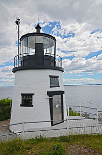
The Owls Head Light is an active aid to navigation located at the entrance of Rockland Harbor on western Penobscot Bay in the town of Owls Head, Knox County, Maine. The lighthouse is owned by the U.S. Coast Guard and licensed to the American Lighthouse Foundation. It is the centerpiece of 13-acre (5.3 ha) Owls Head State Park and was added to the National Register of Historic Places as Owls Head Light Station in 1978.
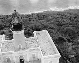
Caja de Muertos Light, is an 1887 lighthouse in Ponce, Puerto Rico, that is unique amongst all other lighthouses in Puerto Rico for its unusual Cross of Lorraine, double-arm, T-type shape structure. The historic lighthouse is located in Caja de Muertos, an uninhabited island off the coast of Ponce, Puerto Rico. The light stands at the highest point of the island.
The Grand Island Harbor Rear Range Light is a lighthouse located off M-28 in Munising Township, Michigan. It is also known as the Bay Furnace Rear Range Light, Christmas Rear Range Light, or End of the Road Light. The corresponding front range light was replaced in 1968; the rear range light was listed on the National Register of Historic Places in 1990. It is no longer an active aid to navigation.

Booby Island Light is an active heritage-listed lighthouse located on Booby Island in the Shire of Torres, near the tip of Cape York Peninsula, west of Prince of Wales Island, within the Endeavour Strait, Queensland, Australia. It marks the western entrance to the navigation channel through the Torres Strait. It was the last of the major lights to be constructed along the Queensland coast.

Cape Moreton Light, also listed as North Point Range Rear Light, is a heritage-listed active lighthouse located on Cape Moreton, a rocky headland located at the north eastern tip of Moreton Island, a large sand island on the eastern side of Moreton Bay, on the coast of South East Queensland, Australia. It marks the northern entrance to Moreton Bay and Brisbane and also serves as the rear light for the North Point Range. With its two distinctive red bands, it also serves as a daymark. It is the oldest lighthouse in Queensland, and the only one to be built by the New South Wales Government before the separation of Queensland, which took place in 1859. It is also the only lighthouse in Queensland to be built of stone.
The Keweenaw Waterway Lower Entrance Light, also known as the Portage Entry Light, is a lighthouse located at the south end of breakwater at mouth of the Portage River in Torch Lake Township. It was listed on the National Register of Historic Places in 2014.


