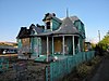
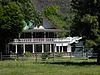
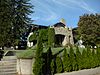
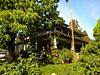
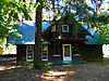
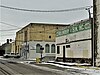
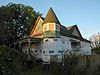
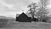
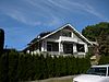
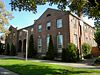
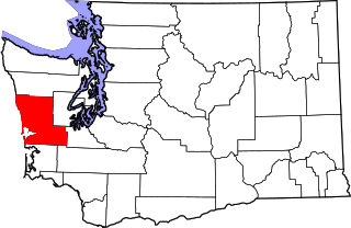
[3] Name on the Register Image Date listed [4] Location City or town Description 1 E. William Brackett House E. William Brackett House October 25, 1990 (# 90001605 2606 Tieton Dr. 46°35′34″N 120°32′35″W / 46.592778°N 120.543056°W / 46.592778; -120.543056 (E. William Brackett House ) Yakima 2 Brooker-Taylor House Brooker-Taylor House February 18, 1987 (# 87000061 203 S. Naches Ave. 46°36′03″N 120°29′49″W / 46.600833°N 120.496944°W / 46.600833; -120.496944 (Brooker-Taylor House ) Yakima 3 Buckeye Ranch House Buckeye Ranch House November 2, 1990 (# 90001735 10881 WA 410 46°47′55″N 120°53′19″W / 46.798611°N 120.888611°W / 46.798611; -120.888611 (Buckeye Ranch House ) Naches 4 Bumping Lake Cabin No. 16 Bumping Lake Cabin No. 16 January 23, 2013 (# 12001223 1920 Bumping Lake Road 46°51′27″N 121°19′02″W / 46.857521°N 121.317304°W / 46.857521; -121.317304 (Bumping Lake Cabin No. 16 ) Naches vicinity 5 Bumping Lake Resort Bumping Lake Resort August 28, 2013 (# 13000211 781 Bumping Lake Rd. 46°52′36″N 121°18′10″W / 46.876660°N 121.302726°W / 46.876660; -121.302726 (Bumping Lake Resort ) Naches vicinity 6 Capitol Theatre Capitol Theatre April 11, 1973 (# 73001895 19 S. 3rd St. 46°36′09″N 120°30′08″W / 46.602383°N 120.502361°W / 46.602383; -120.502361 (Capitol Theatre ) Yakima 7 Carbonneau Mansion Carbonneau Mansion December 12, 1976 (# 76001927 620 S. 48th Ave. 46°35′29″N 120°34′22″W / 46.591389°N 120.572778°W / 46.591389; -120.572778 (Carbonneau Mansion ) Yakima 8 Rupert Card House Rupert Card House February 18, 1987 (# 87000063 1105 W. A St. 46°35′59″N 120°31′27″W / 46.599722°N 120.524167°W / 46.599722; -120.524167 (Rupert Card House ) Yakima 9 Elizabeth Loudon Carmichael House Elizabeth Loudon Carmichael House May 1, 1991 (# 91000538 108 W. Pine St. 46°33′06″N 120°28′34″W / 46.551667°N 120.476111°W / 46.551667; -120.476111 (Elizabeth Loudon Carmichael House ) Union Gap 10 Carmichael-Loudon House Carmichael-Loudon House February 18, 1987 (# 87000065 2 Chicago Ave. 46°35′51″N 120°31′36″W / 46.5975°N 120.526667°W / 46.5975; -120.526667 (Carmichael-Loudon House ) Yakima 11 Cornell Farmstead Cornell Farmstead February 17, 1987 (# 87000055 Pleasant Rd. and Old Prosser Rd. 46°14′35″N 119°53′41″W / 46.243056°N 119.894722°W / 46.243056; -119.894722 (Cornell Farmstead ) Grandview 12 Harrison Dills House Harrison Dills House February 18, 1987 (# 87000066 4 N. Sixteenth Ave. 46°35′51″N 120°31′47″W / 46.5975°N 120.529722°W / 46.5975; -120.529722 (Harrison Dills House ) Yakima 13 Donald House Donald House December 12, 1976 (# 76001928 304 N. 2nd St. 46°36′24″N 120°30′21″W / 46.606667°N 120.505833°W / 46.606667; -120.505833 (Donald House ) Yakima 14 Donald-Wapato Bridge Donald-Wapato Bridge May 24, 1995 (# 95000629 Donald Rd. over the Yakima R. 46°27′58″N 120°23′51″W / 46.466111°N 120.3975°W / 46.466111; -120.3975 (Donald-Wapato Bridge ) Wapato Bridges of Washington State MPS 15 Edgar Rock Lodge Edgar Rock Lodge August 1, 1996 (# 96000843 380 Old Naches Rd. 46°55′16″N 121°03′03″W / 46.921111°N 121.050833°W / 46.921111; -121.050833 (Edgar Rock Lodge ) Naches 16 First Baptist Church First Baptist Church April 5, 2016 (# 16000147 515 East Yakima Ave. 46°36′15″N 120°29′56″W / 46.604198°N 120.498884°W / 46.604198; -120.498884 (First Baptist Church ) Yakima 17 Fort Simcoe State Park Fort Simcoe State Park June 27, 1974 (# 74001994 Southwest of Yakima on WA 220 46°20′34″N 120°50′08″W / 46.342778°N 120.835556°W / 46.342778; -120.835556 (Fort Simcoe State Park ) Yakima 18 Fruit and Produce Row Historic District Fruit and Produce Row Historic District January 4, 2024 (# 100009696 Both sides of North First Ave, from West Yakima Ave north to West D St 46°36′14″N 120°30′39″W / 46.6039°N 120.51086°W / 46.6039; -120.51086 (Fruit and Produce Row Historic District ) Yakima 19 O. J. Gendron Ranch O. J. Gendron Ranch September 21, 2005 (# 05001062 6702 Bell Rd. 46°33′34″N 120°24′57″W / 46.559444°N 120.415833°W / 46.559444; -120.415833 (O. J. Gendron Ranch ) Moxee City 20 H. M. Gilbert House H. M. Gilbert House August 23, 1985 (# 85001812 2109 W. Yakima Ave. 46°35′51″N 120°32′11″W / 46.5975°N 120.536389°W / 46.5975; -120.536389 (H. M. Gilbert House ) Yakima 21 James Gleed Barn James Gleed Barn May 10, 1990 (# 90000672 1960 Old Naches Hwy. 46°39′42″N 120°36′13″W / 46.661667°N 120.603611°W / 46.661667; -120.603611 (James Gleed Barn ) Naches 22 Daniel Goodman House Daniel Goodman House October 2, 1992 (# 92001286 701 S. 3rd Ave. 46°35′28″N 120°30′28″W / 46.591111°N 120.507778°W / 46.591111; -120.507778 (Daniel Goodman House ) Yakima 23 Gotchen Creek Ranger Station Gotchen Creek Ranger Station April 25, 2007 (# 07000369 Forest Service Road 8225.060 46°05′23″N 121°29′04″W / 46.089592°N 121.484517°W / 46.089592; -121.484517 (Gotchen Creek Ranger Station ) Gifford Pinchot National Forest 24 Grandview Herald Building Grandview Herald Building February 17, 1987 (# 87000056 107 Division St. 46°15′21″N 119°54′01″W / 46.255833°N 119.900278°W / 46.255833; -119.900278 (Grandview Herald Building ) Grandview 25 Grandview High School Grandview High School February 17, 1987 (# 87000058 913 W. Second St. 46°15′18″N 119°54′54″W / 46.25488°N 119.91499°W / 46.25488; -119.91499 (Grandview High School ) Grandview 26 Grandview Road-Yellowstone Trail Grandview Road-Yellowstone Trail December 11, 1995 (# 95001446 Grandview Pavement Rd. between Mabton-Sunnyside Rd. and Apple Way 46°15′01″N 119°59′50″W / 46.250278°N 119.997222°W / 46.250278; -119.997222 (Grandview Road-Yellowstone Trail ) Grandview 27 Grandview State Bank Grandview State Bank February 17, 1987 (# 87000060 100 W. Second St. 46°15′17″N 119°54′04″W / 46.254722°N 119.901111°W / 46.254722; -119.901111 (Grandview State Bank ) Grandview 28 Grave of the Legendary Giantess Grave of the Legendary Giantess December 14, 1978 (# 78002789 Address Restricted Toppenish Not an actual grave, but a rock formation some think looks to have the outline of a woman. 29 James Greene House James Greene House May 6, 1987 (# 87000059 203 N. Ninth St. 46°36′32″N 120°29′37″W / 46.608889°N 120.493611°W / 46.608889; -120.493611 (James Greene House ) Yakima 30 A. E. Howard House A. E. Howard House February 18, 1987 (# 87000067 602 N. First St. 46°36′36″N 120°30′32″W / 46.61°N 120.508889°W / 46.61; -120.508889 (A. E. Howard House ) Yakima 31 Howay-Dykstra House Howay-Dykstra House February 17, 1987 (# 87000062 114 Birch St. 46°15′19″N 119°53′53″W / 46.255278°N 119.898056°W / 46.255278; -119.898056 (Howay-Dykstra House ) Grandview 32 William N. Irish House William N. Irish House March 31, 1992 (# 92000280 210 S. 28th Ave. 46°35′48″N 120°32′43″W / 46.596667°N 120.545278°W / 46.596667; -120.545278 (William N. Irish House ) Yakima 33 Kamiakin's Gardens Kamiakin's Gardens December 22, 1976 (# 76001926 West of Union Gap on Lower Ahtanum Rd. 46°31′46″N 120°49′32″W / 46.529444°N 120.825556°W / 46.529444; -120.825556 (Kamiakin's Gardens ) Union Gap 34 James Knuppenburg House James Knuppenburg House February 18, 1987 (# 87000070 111 S. Ninth St. 46°36′10″N 120°29′30″W / 46.602778°N 120.491667°W / 46.602778; -120.491667 (James Knuppenburg House ) Yakima 35 LaFramboise Farmstead LaFramboise Farmstead February 28, 1985 (# 85000400 5204 Mieras Rd. 46°34′37″N 120°25′44″W / 46.576944°N 120.428889°W / 46.576944; -120.428889 (LaFramboise Farmstead ) Yakima 36 A. E. Larson Building A. E. Larson Building September 11, 1984 (# 84003647 6 S. 2nd St. 46°36′08″N 120°30′13″W / 46.602222°N 120.503611°W / 46.602222; -120.503611 (A. E. Larson Building ) Yakima 37 Larson-Hellieson House Larson-Hellieson House May 6, 1987 (# 87000073 208 N. Naches Ave. 46°36′25″N 120°30′03″W / 46.606944°N 120.500833°W / 46.606944; -120.500833 (Larson-Hellieson House ) Yakima 38 William Lindsey House William Lindsey House February 18, 1987 (# 87000075 301 N. Eighth St. 46°36′32″N 120°29′44″W / 46.608889°N 120.495556°W / 46.608889; -120.495556 (William Lindsey House ) Yakima 39 Lund Building Lund Building October 13, 1983 (# 83004276 5 N. Front St. 46°36′08″N 120°30′23″W / 46.602222°N 120.506389°W / 46.602222; -120.506389 (Lund Building ) Yakima 40 Mabton High School Mabton High School November 21, 1985 (# 85002917 High School Rd. 46°12′44″N 119°59′25″W / 46.212222°N 119.990278°W / 46.212222; -119.990278 (Mabton High School ) Mabton 41 Masonic Temple Masonic Temple February 16, 1996 (# 96000051 321 E. Yakima Ave. 46°36′13″N 120°30′02″W / 46.603611°N 120.500556°W / 46.603611; -120.500556 (Masonic Temple ) Yakima Also known as the Great Western Building. 42 Mattoon Cabin Mattoon Cabin October 28, 1977 (# 77001371 South of Sawyer on U.S. 12 46°27′07″N 120°21′23″W / 46.451944°N 120.356389°W / 46.451944; -120.356389 (Mattoon Cabin ) Sawyer 43 Alexander McAllister House Alexander McAllister House October 25, 1990 (# 90001603 402 W. White St. 46°32′59″N 120°28′47″W / 46.549722°N 120.479722°W / 46.549722; -120.479722 (Alexander McAllister House ) Union Gap 44 John J. Miller House John J. Miller House February 18, 1987 (# 87000078 9 S. Tenth Ave. 46°35′52″N 120°31′16″W / 46.597778°N 120.521111°W / 46.597778; -120.521111 (John J. Miller House ) Yakima 45 Francis Mineau House Francis Mineau House February 18, 1987 (# 87000079 216 N. Seventh St. 46°36′28″N 120°29′51″W / 46.607778°N 120.4975°W / 46.607778; -120.4975 (Francis Mineau House ) Yakima 46 Edward B. Moore House Edward B. Moore House February 18, 1987 (# 87000081 222 N. Second St. 46°35′49″N 120°30′20″W / 46.596944°N 120.505556°W / 46.596944; -120.505556 (Edward B. Moore House ) Yakima 47 Morse House Morse House February 17, 1987 (# 87000064 404 E. Main St. 46°15′22″N 119°53′46″W / 46.256111°N 119.896111°W / 46.256111; -119.896111 (Morse House ) Grandview 48 Old North Yakima Historic District Old North Yakima Historic District May 2, 1986 (# 86000960 Roughly bounded by E. A St., S. First St., E. Yakima Ave., and the Northern Pacific RR tracks 46°36′10″N 120°30′24″W / 46.602778°N 120.506667°W / 46.602778; -120.506667 (Old North Yakima Historic District ) Yakima 49 Winfield Perrin House Winfield Perrin House February 18, 1987 (# 87000083 12 S. Eleventh Ave. 46°35′52″N 120°32′57″W / 46.597778°N 120.549167°W / 46.597778; -120.549167 (Winfield Perrin House ) Yakima 50 H. W. Potter House H. W. Potter House February 18, 1987 (# 87000084 305 S. Fourth St. 46°35′56″N 120°29′52″W / 46.598889°N 120.497778°W / 46.598889; -120.497778 (H. W. Potter House ) Yakima 51 Powell House Powell House February 18, 1987 (# 87000085 207 S. Ninth St. 46°36′07″N 120°29′30″W / 46.601944°N 120.491667°W / 46.601944; -120.491667 (Powell House ) Yakima 52 James Richey House James Richey House May 6, 1987 (# 87000087 206 N. Naches Ave. 46°36′23″N 120°30′01″W / 46.606389°N 120.500278°W / 46.606389; -120.500278 (James Richey House ) Yakima 53 Rosedell Rosedell July 12, 1990 (# 90001074 1811 W. Yakima Ave. 46°35′52″N 120°31′57″W / 46.597778°N 120.5325°W / 46.597778; -120.5325 (Rosedell ) Yakima 54 W. P. Sawyer House And Orchard W. P. Sawyer House And Orchard November 23, 1977 (# 77001370 U.S. 12 46°27′14″N 120°21′22″W / 46.453889°N 120.356111°W / 46.453889; -120.356111 (W. P. Sawyer House And Orchard ) Sawyer 55 James Sharp House James Sharp House February 18, 1987 (# 87000088 111 N. Ninth St. 46°36′26″N 120°29′36″W / 46.607222°N 120.493333°W / 46.607222; -120.493333 (James Sharp House ) Yakima 56 St. Joseph's Mission St. Joseph's Mission December 22, 1976 (# 76001925 East of Tampico on Tampico Rd. 46°31′54″N 120°45′30″W / 46.531667°N 120.758333°W / 46.531667; -120.758333 (St. Joseph's Mission ) Tampico 57 Reuben Sweet House Reuben Sweet House February 18, 1987 (# 87000089 6 Chicago Ave. 46°35′52″N 120°31′36″W / 46.597778°N 120.526667°W / 46.597778; -120.526667 (Reuben Sweet House ) Yakima 58 Teapot Dome Service Station Teapot Dome Service Station August 29, 1985 (# 85001943 Old State HW 12 46°23′16″N 120°14′02″W / 46.387778°N 120.233889°W / 46.387778; -120.233889 (Teapot Dome Service Station ) Zillah 59 Toppenish-Zillah Bridge Toppenish-Zillah Bridge May 24, 1995 (# 95000630 Over the Yakima R., between Toppenish and Zillah 46°23′59″N 120°16′49″W / 46.399722°N 120.280278°W / 46.399722; -120.280278 (Toppenish-Zillah Bridge ) Toppenish Bridges of Washington State MPS 60 U.S. Post Office and Courthouse U.S. Post Office and Courthouse November 27, 1979 (# 79002568 25 S. 3rd St 46°36′07″N 120°30′08″W / 46.60202°N 120.502146°W / 46.60202; -120.502146 (U.S. Post Office and Courthouse ) Yakima 61 Union Pacific Freight Building Union Pacific Freight Building September 8, 1988 (# 88001519 104 W. Yakima Ave. 46°36′04″N 120°30′32″W / 46.601111°N 120.508889°W / 46.601111; -120.508889 (Union Pacific Freight Building ) Yakima 62 US Post Office-Sunnyside Main US Post Office-Sunnyside Main May 30, 1991 (# 91000656 713 E. Edison Ave. 46°19′25″N 120°00′36″W / 46.323611°N 120.01°W / 46.323611; -120.01 (US Post Office-Sunnyside Main ) Sunnyside 63 US Post Office-Toppenish Main US Post Office-Toppenish Main August 7, 1991 (# 91000658 14 Jefferson Ave. 46°22′32″N 120°18′44″W / 46.375571°N 120.312108°W / 46.375571; -120.312108 (US Post Office-Toppenish Main ) Toppenish 64 William Watt House William Watt House February 18, 1987 (# 87000091 1511 W. Chestnut Ave. 46°35′47″N 120°31′44″W / 46.596389°N 120.528889°W / 46.596389; -120.528889 (William Watt House ) Yakima 65 Dr. Edmond West House Dr. Edmond West House February 18, 1987 (# 87000092 202 S. Sixteenth Ave. 46°35′46″N 120°31′46″W / 46.596111°N 120.529444°W / 46.596111; -120.529444 (Dr. Edmond West House ) Yakima 66 Charles Wilcox House Charles Wilcox House February 18, 1987 (# 87000093 220 N. Sixteenth Ave. 46°36′05″N 120°31′47″W / 46.601389°N 120.529722°W / 46.601389; -120.529722 (Charles Wilcox House ) Yakima 67 Yakima Indian Agency Building Yakima Indian Agency Building May 19, 1988 (# 88000605 1 S. Elm 46°22′44″N 120°18′55″W / 46.37893°N 120.31531°W / 46.37893; -120.31531 (Yakima Indian Agency Building ) Toppenish 68 Yakima Valley Filipino Community Hall Yakima Valley Filipino Community Hall December 21, 2023 (# 100009632 211 W 2nd Street 46°26′49″N 120°25′18″W / 46.4469°N 120.4217°W / 46.4469; -120.4217 (Yakima Valley Filipino Community Hall ) Wapato 69 Yakima Valley Transportation Company Yakima Valley Transportation Company October 8, 1992 (# 84004012 Third Ave. and Pine St. 46°35′56″N 120°36′09″W / 46.598889°N 120.6025°W / 46.598889; -120.6025 (Yakima Valley Transportation Company ) Yakima 70 Fred and Elizabeth Young House Fred and Elizabeth Young House April 1, 2011 (# 11000150 804 S. 22nd Ave. 46°35′22″N 120°32′19″W / 46.589444°N 120.538611°W / 46.589444; -120.538611 (Fred and Elizabeth Young House ) Yakima 71 Young Women's Christian Association Building Young Women's Christian Association Building April 29, 1993 (# 93000361 15 N. Naches Ave. 46°36′17″N 120°30′00″W / 46.60483°N 120.50006°W / 46.60483; -120.50006 (Young Women's Christian Association Building ) Yakima