Mabton, Washington

Last updated

Mabton
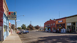
Mabton WA, September 2015.jpg
Main Street
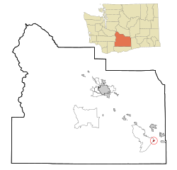
Yakima County Washington Incorporated and Unincorporated areas Mabton Highlighted.svg
Location of Mabton, Washington
Coordinates: 46°12′42″N119°59′47″W / 46.21167°N 119.99639°W / 46.21167; -119.99639
CountryUnited States
State Washington
County Yakima
IncorporatedNovember 7, 1905
Government
  Type Mayor–council [1]
   Mayor Rachel Ruelas [2]
Area
[3]
  Total0.82 sq mi (2.13 km2)
  Land0.82 sq mi (2.13 km2)
  Water0.00 sq mi (0.00 km2)
Elevation
715 ft (218 m)
Population
 (2020) [4]
  Total1,959
  Estimate 
(2021) [5]
1,948
  Density2,752.43/sq mi (1,062.70/km2)
Time zone UTC-8 (PST)
  Summer (DST) UTC-7 (PDT)
ZIP code
98935
Area code 509
FIPS code 53-40980
GNIS feature ID1512417 [6]
Website cityofmabton.com

Mabton is a city in Yakima County, Washington, United States. The population was 1,959 at the 2020 census. [4] Incorporated during the first few years of the 20th century, it is located at the eastern edge of the Yakama Indian Reservation.

Contents

History

The Mabton area's original inhabitants were the Yakama people, who were forced onto a reservation in 1855. Mabton's existence as a town is due to the Northern Pacific Railway, which arrived in the area around 1884 and built a water tower and section house on the site. Nothing else existed at Mabton until 1892 when Sam P. Flower built a store and a warehouse. He soon became the town's first postmaster. Mabton was named by Charlie Sandburg, a Swedish railworker, who proposed the name "Mabletown" for the wife (or daughter) of a railroad official who had spoken kind words to track workers during an inspection. [7] By 1895, Mabton had several stores, a hotel, a railroad depot and a schoolhouse. The Mabton Townsite Company, formed by Sam P. Flower and J.A. Humphrey, made the first plat in 1902, and by 1904, it had more than a dozen businesses and a newspaper. The town of Mabton officially incorporated on November 7, 1905.

Today, residents primarily are employed in occupations related to agriculture, especially hop growing and grape growing.

The Mabton School District has been the repeated beneficiary of grants from the Bill and Melinda Gates Foundation:

A small ranch near Mabton was home to the first confirmed case of mad cow disease in the United States on December 23, 2003, [8] later confirmed to be a cow of Canadian origin imported to the U.S. [9]

Geography

Mabton is located at the east end of the Yakama Indian Reservation and south of the Yakima River near Sunnyside and Grandview. [10] According to the United States Census Bureau, the city has a total area of 0.80 square miles (2.07 km2), all of it land. [11]

Demographics

Historical population
CensusPop.Note
1910 666
1920 547−17.9%
1930 423−22.7%
1940 48514.7%
1950 83171.3%
1960 95815.3%
1970 926−3.3%
1980 1,24834.8%
1990 1,48218.8%
2000 1,89127.6%
2010 2,28620.9%
2020 1,959−14.3%
2021 (est.)1,948 [5] −0.6%
U.S. Decennial Census [12]
2020 Census [4]

2010 census

As of the 2010 census, there were 2,286 people, 528 households, and 478 families living in the city. The population density was 2,857.5 inhabitants per square mile (1,103.3/km2). There were 548 housing units at an average density of 685.0 units per square mile (264.5 units/km2). The racial makeup of the city was 46.9% White, 0.7% African American, 0.2% Native American, 0.2% Asian, 48.4% from other races, and 3.6% from two or more races. Hispanic or Latino of any race were 91.9% of the population.

There were 528 households, of which 69.1% had children under the age of 18 living with them, 55.9% were married couples living together, 25.0% had a female householder with no husband present, 9.7% had a male householder with no wife present, and 9.5% were non-families. 7.0% of all households were made up of individuals, and 3.6% had someone living alone who was 65 years of age or older. The average household size was 4.31 and the average family size was 4.41.

The median age in the city was 23.6 years. 39.4% of residents were under the age of 18; 12.5% were between the ages of 18 and 24; 25.9% were from 25 to 44; 16.5% were from 45 to 64; and 5.8% were 65 years of age or older. The gender makeup of the city was 49.0% male and 51.0% female.

2000 census

As of the 2000 census, there were 1,891 people, 445 households, and 381 families living in the city. The population density was 1,553.4 people/km2 (4,023 people/sq mi). There were 463 housing units at an average density of 380.4 units per square kilometre (985 units/sq mi). The racial makeup of the city was 21.73% White, 0.11% African American, 0.48% Native American, 1.00% Asian, 0.00% Pacific Islander, 73.88% from other races, and 2.80% from two or more races. 89.00% of the population were Hispanic or Latino of any race.

There were 445 households, out of which 60.0% had children under the age of 18 living with them, 59.3% were married couples living together, 17.3% had a woman whose husband does not live with her, and 14.2% were non-families. 12.4% of all households were made up of individuals, and 5.8% had someone living alone who was 65 years of age or older. The average household size was 4.22 and the average family size was 4.54.

In the city, the population was spread out, with 41.9% under the age of 18, 12.9% from 18 to 24, 25.8% from 25 to 44, 12.9% from 45 to 64, and 6.5% who were 65 years of age or older. The median age was 22 years. For every 100 females, there were 104.0 males. For every 100 females age 18 and over, there were 104.1 males.

The median income for a household in the city was $26,650, and the median income for a family was $26,198. Males had a median income of $18,917 versus $21,667 for females. The per capita income for the city was $7,694. 32.7% of the population and 27.9% of families were below the poverty line. Out of the total people living in poverty, 44.0% were under the age of 18 and 18.2% were 65 or older.
Education

The city's library is open six afternoons and three evenings per week. In a space of about 1,260 sq ft (117 m2) it has over 5,000 volumes of hardback books, over 2000 paperbacks, and 26 magazine subscriptions. Many of its books and magazines are in Spanish.

Notable people

Related Research Articles

<span class="mw-page-title-main">Hudson, Iowa</span> City in Iowa, United States

Hudson is a city in Black Hawk County, Iowa, United States. The population was 2,546 at the time of the 2020 census. The rural community of Hudson has grown in recent years and is included as a part of the Waterloo-Cedar Falls Metropolitan Statistical Area.

<span class="mw-page-title-main">Osterdock, Iowa</span> City in Iowa, United States

Osterdock is a city located in Clayton County, Iowa, United States. As of the 2020 census, the city had a total population of 43, down from 50 in 2000.

<span class="mw-page-title-main">Dundee, Iowa</span> City in Iowa, United States

Dundee is a city in Delaware County, Iowa, United States. The population was 198 at the time of the 2020 census.

<span class="mw-page-title-main">Masonville, Iowa</span> City in Iowa, United States

Masonville is a city in Delaware County, Iowa, United States. The population was 99 at the time of the 2020 census. The city is located on the western border between Delaware and Buchanan counties.

<span class="mw-page-title-main">West Burlington, Iowa</span> City in Iowa, United States

West Burlington is a city in Des Moines County, Iowa, United States, adjacent to the Mississippi River city of Burlington. The population was 3,197 at the 2020 census. It is part of the Burlington, IA–IL Micropolitan Statistical Area.

<span class="mw-page-title-main">Logan, Iowa</span> City in Iowa, United States

Logan is a city and county seat of Harrison County, Iowa, United States, along the Boyer River. The population was 1,397 at the time of the 2020 census.

<span class="mw-page-title-main">St. Donatus, Iowa</span> City in Iowa, United States

St. Donatus is a city in Jackson County, Iowa, United States. The population was 120 at the time of the 2020 census. St. Donatus is known for its status as a Luxembourger village, with historic architecture and views along U.S. Route 52. It is the home of a historic Catholic church, which is dedicated to Saint Donatus of Muenstereifel, the town's namesake. It was formerly named Tete Des Morts, which is the name of a creek that flows through the village.

<span class="mw-page-title-main">Hills, Iowa</span> City in Iowa, United States

Hills is a city in Johnson County, Iowa, United States. It is part of the Iowa City, Iowa Metropolitan Statistical Area. The population was 863 at the time of the 2020 census. It is part of the Iowa City Community School District.

<span class="mw-page-title-main">Keomah Village, Iowa</span> City in Iowa, United States

Keomah Village is a city in Mahaska County, Iowa, United States. The population was 110 at the time of the 2020 census. Keomah Village is located adjacent to Lake Keomah State Park.

<span class="mw-page-title-main">College Springs, Iowa</span> City in Iowa, United States

College Springs is a city in Page County, Iowa, United States. The population was 172 at the 2020 census.

<span class="mw-page-title-main">McClelland, Iowa</span> City in Iowa, United States

McClelland is a city in Pottawattamie County, Iowa, United States. The city was founded in 1903 after the Great Western Railroad was extended to include Council Bluffs, Iowa The population was 146 at the time of the 2020 census.

<span class="mw-page-title-main">Benton, Iowa</span> City in Iowa, United States

Benton is a city in Ringgold County, Iowa, United States. The population was 39 at the 2020 census.

<span class="mw-page-title-main">Lake Shore, Minnesota</span> City in Minnesota, United States

Lake Shore is a city in Cass County, Minnesota, United States. The population was 1,056 at the 2020 census. It is part of the Brainerd Micropolitan Statistical Area.

<span class="mw-page-title-main">Trommald, Minnesota</span> City in Minnesota, United States

Trommald is a city in Crow Wing County, Minnesota, United States. The population was 99 at the 2020 census. It is part of the Brainerd Micropolitan Statistical Area.

<span class="mw-page-title-main">Clarkson Valley, Missouri</span> City in Missouri, United States

Clarkson Valley is a city in St. Louis County, Missouri, United States. The population was 2,609 at the 2020 census.

<span class="mw-page-title-main">Central City, South Dakota</span> City in South Dakota, United States

Central City is a city in Lawrence County, South Dakota, United States. The population was 93 at the 2020 census.

<span class="mw-page-title-main">Harrah, Washington</span> Town in Washington, United States

Harrah is a town in Yakima County, Washington, United States. The population was 585 at the 2020 census. It is on the Yakama Indian Reservation. The mayor is Barbara Harrer.

<span class="mw-page-title-main">Toppenish, Washington</span> City in Washington, United States

Toppenish is a city in Yakima County, Washington. As of the 2020 census, the city population was 8,854. It is located within the Yakama Indian Reservation, established in 1855.

<span class="mw-page-title-main">Lester, West Virginia</span> Town in West Virginia, United States

Lester is a town in Raleigh County, West Virginia, United States. The population was 337 at the 2020 census. The community was named after Champ Lester, a local pioneer.

<span class="mw-page-title-main">Barnes City, Iowa</span> City in Iowa, United States

Barnes City is a city in Mahaska and Poweshiek counties in the U.S. state of Iowa. The population was 156 at the 2020 census.

References

  1. "Mabton, Washington - Code of Ordinances Title 1 - GENERAL PROVISIONS". municode.com. Retrieved April 10, 2022.
  2. "City Government". City of Mabton. Retrieved April 10, 2022.
  3. "2019 U.S. Gazetteer Files". United States Census Bureau. Retrieved August 7, 2020.
  4. 1 2 3 "Explore Census Data". United States Census Bureau . Retrieved September 13, 2022.
  5. 1 2 "City and Town Population Totals: 2020-2021". United States Census Bureau. September 13, 2022. Retrieved September 13, 2022.
  6. "US Board on Geographic Names". United States Geological Survey. October 25, 2007. Retrieved January 31, 2008.
  7. Katherine Trembley Wernex (1979), It Did Happen Here: A Living History of Old Mabton, Prosser, Washington: Perfect, p. 2
  8. Historylink.org (Washington State History online encyclopedia), First U.S. case of mad cow disease is reported
  9. "Investigators Trace Diseased Cow to Canada". Archived from the original on February 11, 2004. Retrieved October 4, 2013.
  10. "US Gazetteer files 2010". United States Census Bureau. Archived from the original on January 25, 2012. Retrieved December 19, 2012.
  11. United States Census Bureau. "Census of Population and Housing" . Retrieved July 22, 2014.