Summitview, Washington

Last updated • 2 min readFrom Wikipedia, The Free Encyclopedia
Summitview, Washington
CDP
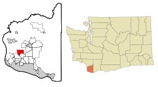
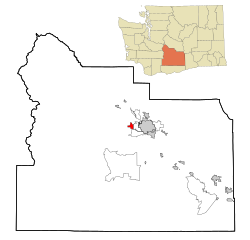
Yakima County Washington Incorporated and Unincorporated areas Summitview Highlighted.svg
Location of Summitview, Washington
Coordinates: 46°35′54″N120°38′18″W / 46.59833°N 120.63833°W / 46.59833; -120.63833 Coordinates: 46°35′54″N120°38′18″W / 46.59833°N 120.63833°W / 46.59833; -120.63833
CountryUnited States
State Washington
County Yakima
Area
  Total2.6 sq mi (6.7 km2)
  Land2.6 sq mi (6.7 km2)
  Water0.0 sq mi (0.0 km2)
Elevation
1,276 ft (389 m)
Population
 (2010)
  Total967
  Density348.6/sq mi (134.6/km2)
Time zone UTC-8 (Pacific (PST))
  Summer (DST) UTC-7 (PDT)
FIPS code 53-68417 [1]
GNIS feature ID1852959 [2]

Summitview is a census-designated place (CDP) in Yakima County, Washington, United States. The population was 967 at the 2010 census.

Contents

Based on per capita income, Summitview ranks 18th of 522 areas in the state of Washington to be ranked. It is also the highest rank achieved in Yakima County.[ citation needed ]

Geography

Summitview is located at 46°35′54″N120°38′18″W / 46.59833°N 120.63833°W / 46.59833; -120.63833 (46.598447, -120.638403). [3]

According to the United States Census Bureau, the CDP has a total area of 2.6 square miles (6.7 km2), all of it land.

Demographics

As of the census [1] of 2000, there were 900 people, 294 households, and 256 families residing in the CDP. The population density was 348.6 people per square mile (134.7/km2). There were 308 housing units at an average density of 119.3/sq mi (46.1/km2). The racial makeup of the CDP was 94.33% White, 0.33% Native American, 0.22% Pacific Islander, 3.33% from other races, and 1.78% from two or more races. Hispanic or Latino of any race were 7.78% of the population.

There were 294 households, out of which 45.9% had children under the age of 18 living with them, 79.3% were married couples living together, 5.4% had a female householder with no husband present, and 12.9% were non-families. 9.9% of all households were made up of individuals, and 2.7% had someone living alone who was 65 years of age or older. The average household size was 3.06 and the average family size was 3.29.

In the CDP, the age distribution of the population shows 29.8% under the age of 18, 6.4% from 18 to 24, 27.0% from 25 to 44, 26.6% from 45 to 64, and 10.2% who were 65 years of age or older. The median age was 40 years. For every 100 females, there were 100.4 males. For every 100 females age 18 and over, there were 103.9 males.

The median income for a household in the CDP was $66,944, and the median income for a family was $67,083. Males had a median income of $48,036 versus $25,139 for females. The per capita income for the CDP was $36,301. About 2.8% of families and 2.6% of the population were below the poverty line, including none of those under age 18 and 11.5% of those age 65 or over.

Related Research Articles

Yakima County, Washington U.S. county in Washington

Yakima County is a county in the U.S. state of Washington. As of the 2010 census, its population was 243,231. The county seat and largest city is Yakima. The county was formed out of Ferguson County in January 1865 and is named for the Yakama tribe of Native Americans.

Rock Creek, Alabama CDP in Alabama, United States

Rock Creek is a census-designated place in Jefferson County, Alabama, United States. Its location is northwest of Hueytown. At the 2010 census the population was 1,456. This area was damaged by an F5 tornado on April 8, 1998. An EF2 tornado struck northwest from here on January 23, 2012.

First Mesa, Arizona CDP in Arizona, United States

First Mesa is a census-designated place (CDP) in Navajo County, Arizona, United States, on the Hopi Reservation. As of the 2010 census, the CDP population was 1,555, spread among three Hopi villages atop the 5,700-foot mesa: Hano, Sitsomovi, and Waalpi.

Shonto, Arizona CDP in Arizona, United States

Shonto is a census-designated place (CDP) in Navajo County, Arizona, United States. The population was 591 at the 2010 census.

Tranquillity, California census-designated place in California, United States

Tranquillity is a census-designated place (CDP) in Fresno County, California, United States. It is located 10 miles (16 km) southeast of Mendota, at an elevation of 164 feet (50 m). The population was 799 at the 2010 census, down from 813 at the 2000 census. Tranquillity High School is the only high school in Tranquillity.

Johnsville, California census-designated place in California, United States

Johnsville is a census-designated place (CDP) in Plumas County, California, United States. The population was 20 at the 2010 census, down from 21 at the 2000 census.

Greenville, Delaware CDP in Delaware, United States

Greenville is a census-designated place (CDP) in New Castle County, Delaware, United States. The population was 2,326 at the 2010 census. The CDP is an affluent bedroom community and a suburb of Wilmington, Delaware. The community is also home to many Du Pont family descendants.

Fruit Cove, Florida CDP in Florida, United States

Fruit Cove is a census-designated place (CDP) in St. Johns County, Florida, United States. The population was 16,077 at the 2000 census. It is located in the community of St. Johns.

Lorane, Pennsylvania Census-designated place in Pennsylvania, United States

Lorane is a census-designated place (CDP) in Exeter Township, Berks County, Pennsylvania, United States. The population was 4,236 at the 2010 census. Located on the Schuylkill River, US Route 422 runs through the town.

Guilford, Pennsylvania Census-designated place in Pennsylvania, United States

Guilford is a census-designated place (CDP) in Franklin County, Pennsylvania, United States. The population was 2,138 at the 2010 census.

Ahtanum, Washington CDP in Washington, United States

Ahtanum is a census-designated place (CDP) in Yakima County, Washington, United States. The population was 3,601 at the 2010 census.

Eschbach, Washington CDP in Washington, United States

Eschbach is a census-designated place (CDP) in Yakima County, Washington, United States. The population was 415 at the 2010 census.

Gleed, Washington CDP in Washington, United States

Gleed is a census-designated place (CDP) in Yakima County, Washington, United States. The population was 2,906 at the 2010 census.

Satus, Washington CDP in Washington, United States

Satus is a census-designated place (CDP) in Yakima County, Washington, United States. The population was 746 at the 2000 census. It is southwest from the Toppenish National Wildlife Refuge. The community was not recognized in the 2010 census.

Terrace Heights, Washington CDP in Washington, United States

Terrace Heights is a census-designated place (CDP) in Yakima County, Washington, United States. The population was 6,937 at the 2010 census. It is essentially a suburb of the city of Yakima.

Union Gap, Washington City in Washington, United States

Union Gap is a city in Yakima County, Washington, United States. As of the 2010 census, the city population was 6,047. Union Gap has become the retail hub for the entire Yakima Valley as a result of Valley Mall and other thriving businesses being located here. Part of the city is part of the Yakama Nation.

West Valley, Washington CDP in Washington, United States

West Valley is a former census-designated place (CDP) in Yakima County, Washington, United States. The area has been annexed by the city of Yakima. The population was 10,433 at the 2000 census.

White Swan, Washington CDP in Washington, United States

White Swan is a census-designated place (CDP) in Yakima County, Washington, United States. The population was 3,033 at the 2000 census.

North Brookfield (CDP), Massachusetts CDP in Massachusetts, United States

North Brookfield is a census-designated place (CDP) in the town of North Brookfield in Worcester County, Massachusetts, United States. The population was 2,265 at the 2010 census.
Milford (CDP), Maine Census-designated place in Maine, United States

Milford is a census-designated place (CDP) consisting of the main area of settlement within the town of Milford in Penobscot County, Maine, United States. The population was 2,233 at the 2010 census.

References

  1. 1 2 "U.S. Census website". United States Census Bureau . Retrieved 2008-01-31.
  2. "US Board on Geographic Names". United States Geological Survey. 2007-10-25. Retrieved 2008-01-31.
  3. "US Gazetteer files: 2010, 2000, and 1990". United States Census Bureau. 2011-02-12. Retrieved 2011-04-23.