
A ZIP Code is a system of postal codes used by the United States Postal Service (USPS). Introduced on July 1, 1963, the basic format consisted of five digits. In 1983, an extended ZIP+4 code was introduced; it included the five digits of the ZIP Code, followed by a hyphen and four digits that designated a more specific location.

Berlin Charter Township is a charter township of Monroe County in the U.S. state of Michigan. At the 2010 census, the township population was 9,299.

Huron Charter Township is a charter township of Wayne County in the U.S. state of Michigan. The population was 15,879 at the 2010 census. Huron Charter Township is named after the Huron River, which flows southeast through the township. The township is home to three divisions of the Huron–Clinton Metroparks system: Lower Huron, Oakwoods, and Willow.

New Boston is an unincorporated community in Wayne County in the U.S. state of Michigan. The community is located within Huron Charter Township. As an unincorporated community, New Boston has no legally defined boundaries or population statistics of its own.

Old Mission is an unincorporated community in Grand Traverse County in the U.S. state of Michigan. It is located within Peninsula Township near the tip of Old Mission Peninsula along the shores of the East Arm of Grand Traverse Bay. As an unincorporated community, Old Mission has no legally defined boundaries or population statistics of its own.
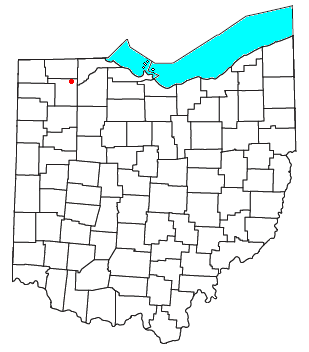
Colton is an unincorporated community in northwestern Washington Township, Henry County, Ohio, United States. It has a post office with the ZIP code 43510. It is located along County Road 4A, approximately four miles north of U.S. Route 24.

Little Hocking is a census-designated place in southern Belpre Township, Washington County, Ohio, United States. It has a post office with the ZIP code 45742.
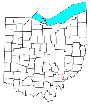
Cutler is an unincorporated community in southwestern Fairfield Township, Washington County, Ohio, United States. It has a post office with the ZIP code 45724. It lies at the intersection of State Route 555 and County Road 59 near Gilbert Run, a subsidiary of the Little Hocking River, which meets the Ohio River at Little Hocking to the southeast.
Togo is an unincorporated community in Carpenter Township, Itasca County, Minnesota, United States.

Eureka is an unincorporated community and census-designated place (CDP) in Clinton County in the U.S. state of Michigan. The population of the CDP was 233 at the 2020 census. The community is located within Greenbush Township.
Dayton is an unincorporated community located in Howard County, Maryland, United States.

Norman is an unincorporated community in northwestern Owen Township, Jackson County, Indiana, United States. It lies along State Road 58 northwest of the town of Brownstown, the county seat of Jackson County. Its elevation is 869 feet (265 m), and it is located at 38°57′9″N86°16′30″W. Because the community had two different names, the Board on Geographic Names officially decided in favor of "Norman" in 1943. Although Norman is unincorporated, it has a post office, with the ZIP code of 47264.
Knickerbocker is an unincorporated community in southwestern Tom Green County, Texas, United States. It lies along Farm to Market Road 2335 southwest of the city of San Angelo, the county seat of Tom Green County. Its elevation is 2,051 feet (625 m). Although Knickerbocker is unincorporated, it has a post office, with the ZIP code of 76939.

Beverly, Washington, United States, is a small unincorporated community along the banks of the Columbia River in central Washington state. The community, which consists of a few hundred residents, is a few miles downriver from Wanapum Dam and is nestled at the base of Sentinel Gap, a water gap in the Saddle Mountains that predates the Columbia River.

Marshall is an unincorporated community in Spokane County, Washington, United States. Named in 1880 for early settler William H. Marshall, Marshall has a post office with ZIP code 99020.
Alverda is an Census-designated place in Indiana County, Pennsylvania, United States. The community is located on Pennsylvania Route 553, 15.5 miles (24.9 km) east of Indiana in Pine Township.

Forbes Road is an unincorporated community in Westmoreland County, Pennsylvania, United States. The community is located along Pennsylvania Route 819, 3.7 miles (6.0 km) north of Greensburg. Forbes Road has a post office with ZIP code 15633, which opened on July 1, 1903.
Strabane is an unincorporated community in Washington County, Pennsylvania, United States. The community is located along the southern border of Canonsburg and the eastern border of Houston. Strabane has a post office, with ZIP code 15363.
North Washington is an unincorporated community in Butler County, Pennsylvania, United States. The community is located at the intersection of state routes 38 and 138, 13.5 miles (21.7 km) north-northeast of Butler. North Washington has a post office with ZIP code 16048.
Aquetong is populated place in Solebury Township, Bucks County, Pennsylvania, United States, situated along U.S. Route 202, approximately 2.9 miles (4.7 km) west of New Hope.


