Eschbach, Washington

Last updated

Eschbach, Washington
CDP
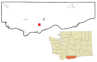
Yakima County Washington Incorporated and Unincorporated areas Eschbach Highlighted.svg
Location of Eschbach, Washington
Coordinates: 46°40′22″N120°38′2″W / 46.67278°N 120.63389°W / 46.67278; -120.63389
CountryUnited States
State Washington
County Yakima
Area
  Total1.4 sq mi (3.6 km2)
  Land1.3 sq mi (3.3 km2)
  Water0.1 sq mi (0.2 km2)
Elevation
1,296 ft (395 m)
Population
 (2020)
  Total441
  Density320/sq mi (120/km2)
Time zone UTC-8 (Pacific (PST))
  Summer (DST) UTC-7 (PDT)
FIPS code 53-22150 [1]
GNIS feature ID1510947 [2]

Eschbach is a census-designated place (CDP) in Yakima County, Washington, United States. The population was 441 at the 2020 census. [3]

Contents

Geography

Eschbach is located at 46°40′22″N120°38′02″W / 46.672760°N 120.633843°W / 46.672760; -120.633843 (46.672760, -120.633843). [4]

According to the United States Census Bureau, the CDP has a total area of 1.4 square miles (3.5 km2), of which, 1.3 square miles (3.3 km2) of it is land and 0.1 square miles (0.2 km2) of it (6.57%) is water.

Demographics

Historical population
CensusPop.Note
2000 400
2010 4153.8%
2020 4416.3%
Sources: [1] [4] [3]

As of the census [1] of 2000, there were 400 people, 143 households, and 113 families residing in the CDP. The population density was 312.6 people per square mile (120.7/km2). There were 148 housing units at an average density of 115.7/sq mi (44.6/km2). The racial makeup of the CDP was 91.75% White, 0.75% African American, 1.00% Native American, 5.50% from other races, and 1.00% from two or more races. Hispanic or Latino of any race were 12.00% of the population.

There were 143 households, out of which 37.8% had children under the age of 18 living with them, 67.8% were married couples living together, 6.3% had a female householder with no husband present, and 20.3% were non-families. 16.8% of all households were made up of individuals, and 7.0% had someone living alone who was 65 years of age or older. The average household size was 2.80 and the average family size was 3.15.

In the CDP, the age distribution of the population shows 27.3% under the age of 18, 6.5% from 18 to 24, 27.0% from 25 to 44, 26.5% from 45 to 64, and 12.8% who were 65 years of age or older. The median age was 40 years. For every 100 females, there were 111.6 males. For every 100 females age 18 and over, there were 104.9 males.

The median income for a household in the CDP was $37,708, and the median income for a family was $36,484. Males had a median income of $35,870 versus $34,875 for females. The per capita income for the CDP was $16,279. None of the families and 1.7% of the population were living below the poverty line, including no under eighteens and none of those over 64.

Related Research Articles

Silver Springs is a census-designated place (CDP) in Copper River Census Area, Alaska, United States. At the 2020 census the population was 111, down from 114 in 2010.

Tolsona is a census-designated place (CDP) in Copper River Census Area, Alaska, United States. The population was 12 at the 2020 census, down from 30 in 2010.

<span class="mw-page-title-main">Raisin City, California</span> Census-designated place in California, United States

Raisin City is a census-designated place (CDP) in Fresno County, California, United States. The population was 380 at the 2010 census, up from 165 at the 2000 census. Raisin City is located 13 miles (21 km) south-southwest of downtown Fresno, at an elevation of 236 feet.

<span class="mw-page-title-main">Tahoe Vista, California</span> Census-designated place in California, United States

Tahoe Vista is a census-designated place located on the north shore of Lake Tahoe in Placer County, California. It is part of the Sacramento–Arden-Arcade–Roseville Metropolitan Statistical Area. The population was 1,433 at the 2010 census, down from 1,668 at the 2000 census.

<span class="mw-page-title-main">Blairsden, California</span> Census-designated place in California, United States

Blairsden is a census-designated place (CDP) in Plumas County, California, United States. Blairsden is located 20 miles (32.2 km) east-southeast of Quincy. It is located on the Feather River Route. The population was 39 at the 2010 census, down from 50 at the 2000 census.

<span class="mw-page-title-main">Spring Garden, California</span> Census-designated place in California, United States

Spring Garden is a census-designated place (CDP) in Plumas County, California, United States. The population was 16 at the 2010 census, down from 55 at the 2000 census.

<span class="mw-page-title-main">Helena Valley Northeast, Montana</span> Census-designated place in Montana, United States

Helena Valley Northeast is a census-designated place (CDP) in Lewis and Clark County, Montana, United States. The population was 2,995 at the 2010 census. It is part of the Helena Micropolitan Statistical Area.

<span class="mw-page-title-main">Clinton, Montana</span> CDP in Montana, United States

Clinton is a census-designated place (CDP) in Missoula County, Montana, United States. It is part of the 'Missoula, Montana Metropolitan Statistical Area'. The CDP was named for General Sir Henry Clinton. The population was 1,052 at the 2010 census, an increase from its population of 549 in 2000.

<span class="mw-page-title-main">Crompond, New York</span> CDP in New York, United States

Crompond is a hamlet and census-designated place (CDP) located in the town of Yorktown in Westchester County, New York, United States. The population was 2,292 at the 2010 census.

<span class="mw-page-title-main">Gantt, South Carolina</span> Census-designated place in South Carolina, United States

Gantt is a census-designated place (CDP) in Greenville County, South Carolina, United States. The population was 14,229 at the 2010 census. It is part of the Greenville–Mauldin–Easley Metropolitan Statistical Area and a suburb of the city of Greenville.

<span class="mw-page-title-main">Modoc, South Carolina</span> CDP in South Carolina, United States

Modoc is a census-designated place (CDP) in McCormick County, South Carolina, United States. The population was 256 at the 2000 census, and 218 at the 2010 census, a decline of 14.8%.

<span class="mw-page-title-main">South Wenatchee, Washington</span> Census-designated place in Washington, United States

South Wenatchee is an unincorporated community and census-designated place (CDP) in Chelan County, Washington, United States. It is part of the Wenatchee–East Wenatchee Metropolitan Statistical Area. The population was 1,522 at the 2020 census.

<span class="mw-page-title-main">Gleed, Washington</span> CDP in Washington, United States

Gleed is a census-designated place (CDP) in Yakima County, Washington, United States. The population was 2,873 at the 2020 census.

<span class="mw-page-title-main">Satus, Washington</span> CDP in Washington, United States

Satus is a census-designated place (CDP) in Yakima County, Washington, United States, located on the eastern corner of the Yakama Indian Reservation. The population was 746 at the 2000 census. It is southwest from the Toppenish National Wildlife Refuge. The community was not recognized in the 2010 census. The area was first settled and established as a post office location in 1890.

<span class="mw-page-title-main">Summitview, Washington</span> CDP in Washington, United States

Summitview is a census-designated place (CDP) in Yakima County, Washington, United States. The population was 2,066 at the 2020 census, a dramatic increase of 967 from the 2010 census.

<span class="mw-page-title-main">Terrace Heights, Washington</span> CDP in Washington, United States

Terrace Heights is a census-designated place (CDP) in Yakima County, Washington, United States. The population was 9,244 at the 2020 census. It is essentially a suburb of the city of Yakima.

<span class="mw-page-title-main">Limestone (CDP), Maine</span> Census-designated place in Maine, United States

Limestone is a census-designated place (CDP) comprising the main village within the town of Limestone in Aroostook County, Maine, United States. The population was 1,075 at the 2010 census, out of a population of 2,314 for the entire town.

Hampden is a census-designated place (CDP) consisting of the eastern portion of the town of Hampden in Penobscot County, Maine, United States. The population of the CDP was 4,343 at the 2010 census.

<span class="mw-page-title-main">Clearbrook, New Jersey</span> Populated place in Middlesex County, New Jersey, US

Clearbrook is a gated community and census-designated place (CDP) located in Monroe Township, Middlesex County, in the U.S. state of New Jersey. It is in the western part of the township, bordered to the north by Encore at Monroe and to the east by Concordia and The Ponds. It is 3.5 miles (5.6 km) southwest of Jamesburg and 5 miles (8 km) northeast of Hightstown.

<span class="mw-page-title-main">Searsport (CDP), Maine</span> CDP in Maine, United States

Searsport is a census-designated place (CDP) in the town of Searsport in Waldo County, Maine, United States. The population was 999 at the 2020 census.

References

  1. 1 2 3 "U.S. Census website". United States Census Bureau . Retrieved January 31, 2008.
  2. "US Board on Geographic Names". United States Geological Survey. October 25, 2007. Retrieved January 31, 2008.
  3. 1 2 "Census Bureau profile: Eschbach, Washington". United States Census Bureau. May 2023. Retrieved May 9, 2024.
  4. 1 2 "US Gazetteer files: 2010, 2000, and 1990". United States Census Bureau. February 12, 2011. Retrieved April 23, 2011.