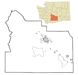
Satus is a census-designated place (CDP) in Yakima County, Washington, United States, located on the eastern corner of the Yakama Indian Reservation. The population was 746 at the 2000 census. It is southwest from the Toppenish National Wildlife Refuge. The community was not recognized in the 2010 census. The area was first settled and established as a post office location in 1890.

Toppenish is a city in Yakima County, Washington. As of the 2020 census, the city population was 8,854. It is located within the Yakama Indian Reservation, established in 1855.

North Springfield is an unincorporated community and census-designated place in the town of Springfield, Windsor County, Vermont, United States. As of the 2010 census, the population of the CDP was 573. It lies at an altitude of 495 feet (151 m). A post office has been operated in North Springfield since 1832. Black River Produce, a major food processor and distributor, is headquartered in the village.
Toppenish National Wildlife Refuge is located on the Yakama Indian Reservation about 6 miles south of Toppenish, Washington, in the agriculturally intensive Yakima Valley of eastern Washington state. Using the waters of Toppenish and Snake Creeks and supplemented with summer irrigation, managers are able to provide a mosaic of refuge wetlands interspersed with lush riparian and native upland habitats.

Pine Ridge is an unincorporated community in Fayette Township, Vigo County, in the U.S. state of Indiana. It is part of the Terre Haute metropolitan area.

Harrison is an unincorporated community in southeastern Fayette Township, Vigo County, in the U.S. state of Indiana.
Buena is an unincorporated community in Yakima County, with a 2010 census population of 990. The community was not recognized in the 2000 census figures. Washington, United States. Buena is 3.5 miles (5.6 km) north of Toppenish. Buena has a post office with ZIP code 98921. Its name originates from Spanish bueno "good".
Donald is a census-designated place and unincorporated community in Yakima County, Washington, United States. The population was 91 at the 2010 census.
Artesian is an unincorporated community in Yakima County, Washington, United States, located approximately one mile east of Moxee.
Ashue is an unincorporated community in Yakima County, Washington, United States, located approximately two mile southwest of Wapato.
Emerald is an unincorporated community in Yakima County, Washington, United States, approximately two miles (3.2 km) west of Sunnyside.
Farron is an unincorporated community in Yakima County, Washington, United States, located approximately five miles southwest of Wapato.
Flint is an unincorporated community in Yakima County, Washington, United States, located approximately three miles east of Wapato.
Venner is an unincorporated community in Yakima County, Washington, United States, located approximately four miles southwest of Wapato.
Liberty is an unincorporated community in Yakima County, Washington, United States, located approximately two miles east of Granger.
Midvale is an unincorporated community in Yakima County, Washington, United States, located immediately south of Sunnyside.
Nass is an unincorporated community in Yakima County, Washington, United States, located approximately one mile east of Granger.
Birchfield is an unincorporated community in Yakima County, Washington, United States, located between Terrace Heights and Moxee.

Cunot is an unincorporated community in Jackson Township, Owen County, in the U.S. state of Indiana. It lies near the intersection of Indiana Highway 42 and Indiana Highway 243, which is a community about twenty miles north of the city of Spencer, the county seat of Owen County. Its elevation is 722 feet, and it is located at 39°27′23″N86°51′17″W. Although this community is located within Owen County on its northern boundary, it has an address of Cloverdale, Indiana, in Putnam County, which is about six miles northeast of the community.


