Outline of Washington (state)

Last updated
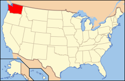
The location of the state of Washington in the United States of America Map of USA WA.svg
The location of the state of Washington in the United States of America

The following outline is provided as an overview of and topical guide to the U.S. state of Washington:

Contents

Washington is a state in the Pacific Northwest region of the United States, and is named after George Washington, the first President of the United States (it is the only U.S. state named after a president). Washington was carved out of the western part of Washington Territory which had been ceded by Britain in 1846 by the Oregon Treaty as settlement of the Oregon Boundary Dispute. It was admitted to the Union as the 42nd state in 1889. The state's population at the 2010 United States Census was 6,724,540. Washington is often called Washington State or the state of Washington to distinguish it from Washington, D.C.
General reference

An enlargeable map of the state of Washington Map of Washington NA.png
An enlargeable map of the state of Washington

Geography of Washington

Places in Washington

Environment of Washington

Natural geographic features of Washington

Regions of Washington

Administrative divisions of Washington

Demography of Washington

Government and politics of Washington

Federal representation

State government of Washington

Executive branch of the government of Washington

Legislative branch of the government of Washington

Judicial branch of the government of Washington

Law and order in Washington

Law of Washington (state)

Military in Washington

Local government in Washington

History of Washington

History of Washington (state)

History of Washington, by period

Culture of Washington

Culture of Washington

The Arts in Washington

Sports in Washington

Economy and infrastructure of Washington

Economy of Washington

Education in Washington

Education in Washington (state)

See also

Related Research Articles

<span class="mw-page-title-main">Oregon Treaty</span> 1846 treaty which ended the Oregon boundary dispute between the US and UK

The Oregon Treaty was a treaty between the United Kingdom and the United States that was signed on June 15, 1846, in Washington, D.C. The treaty brought an end to the Oregon boundary dispute by settling competing American and British claims to the Oregon Country; the area had been jointly occupied by both Britain and the U.S. since the Treaty of 1818.

The 49th parallel north is a circle of latitude that is 49° north of Earth's equator. It crosses Europe, Asia, the Pacific Ocean, North America, and the Atlantic Ocean.

<span class="mw-page-title-main">Pig War (1859)</span> Border dispute between the United States and the United Kingdom

The Pig War was a confrontation in 1859 between the United States and the United Kingdom over the British–U.S. border in the San Juan Islands, between Vancouver Island and the Washington Territory. The Pig War, so called because it was triggered by the shooting of a pig, is also called the Pig Episode, the Pig and Potato War, the San Juan Boundary Dispute, and the Northwestern Boundary Dispute. Despite being referred to as a "war", there were no human casualties on either side.

The Territory of Oregon was an organized incorporated territory of the United States that existed from August 14, 1848, until February 14, 1859, when the southwestern portion of the territory was admitted to the Union as the State of Oregon. Originally claimed by several countries, Spanish "El Orejón" was part of the Territorio de Nutca (1789–1795), later in the 19th century, the region was divided between the British Empire and the US in 1846. When established, the territory encompassed an area that included the current states of Oregon, Washington, and Idaho, as well as parts of Wyoming and Montana. The capital of the territory was first Oregon City, then Salem, followed briefly by Corvallis, then back to Salem, which became the state capital upon Oregon's admission to the Union.

The Territory of Washington was an organized incorporated territory of the United States that existed from March 2, 1853, until November 11, 1889, when the territory was admitted to the Union as the State of Washington. It was created from the portion of the Oregon Territory north of the lower Columbia River and north of the 46th parallel east of the Columbia. At its largest extent, it also included the entirety of modern Idaho and parts of Montana and Wyoming, before attaining its final boundaries in 1863.

<span class="mw-page-title-main">Oregon boundary dispute</span> Early 19th century US–UK boundary dispute

The Oregon boundary dispute or the Oregon Question was a 19th-century territorial dispute over the political division of the Pacific Northwest of North America between several nations that had competing territorial and commercial aspirations in the region.

<span class="mw-page-title-main">Oregon pioneer history</span> Account of the founders Oregon

Oregon pioneer history (1806–1890) is the period in the history of Oregon Country and Oregon Territory, in the present day state of Oregon and Northwestern United States.

<span class="mw-page-title-main">History of Oregon</span>

The history of Oregon, a U.S. state, may be considered in five eras: geologic history, inhabitation by native peoples, early exploration by Europeans, settlement by pioneers, and modern development.

<span class="mw-page-title-main">Index of Oregon-related articles</span>

The following is an alphabetical list of articles related to the U.S. state of Oregon.

<span class="mw-page-title-main">Index of Washington (state)-related articles</span>

The following is an alphabetical list of articles related to the U.S. state of Washington.

<span class="mw-page-title-main">Outline of Idaho</span> Overview of and topical guide to Idaho

The following outline is provided as an overview of and topical guide to the U.S. state of Idaho:

<span class="mw-page-title-main">Outline of Montana</span> Overview of and topical guide to Montana

The following outline is provided as an overview of and topical guide to the U.S. state of Montana:

<span class="mw-page-title-main">Outline of Oregon</span> Overview of and topical guide to Oregon

The following outline is provided as an overview of and topical guide to the U.S. state of Oregon:

<span class="mw-page-title-main">Outline of Wyoming</span> Overview of and topical guide to Wyoming

The following outline is provided as an overview of and topical guide to the U.S. state of Wyoming:

<span class="mw-page-title-main">Outline of Wyoming territorial evolution</span>

The following outline traces the territorial evolution of the U.S. State of Wyoming.

<span class="mw-page-title-main">Outline of Washington territorial evolution</span> Overview of and topical guide to Washington territorial evolution

The following outline traces the territorial evolution of the U.S. State of Washington.

<span class="mw-page-title-main">Outline of Oregon territorial evolution</span> Overview of and topical guide to Oregon territorial evolution

The following outline traces the territorial evolution of the U.S. state of Oregon.

The following is a timeline of the history of Washington state in the United States.

The following is a timeline of the history of Oregon in the United States of America.

References

  1. "Symbols of Washington State". Washington State Legislature. Archived from the original on 2007-03-05. Retrieved 2007-03-11.
  2. Golenpaul, Dan; Kieran, John, eds. (1995). Information Please Alamanac. Dan Golenpaul Associates. p. 780.
  3. "U.S. Census Bureau State & County QuickFacts Washington". Archived from the original on 2016-02-17. Retrieved 2011-11-18.

Gnome-globe.svg Wikimedia Atlas of Washington