National Register of Historic Places listings in Franklin County, Washington

Last updated

Location of Franklin County in Washington Map of Washington highlighting Franklin County.svg
Location of Franklin County in Washington

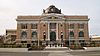
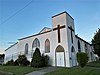
This list presents the full set of buildings, structures, objects, sites, or districts designated on the National Register of Historic Places in Franklin County, Washington, and offers brief descriptive information about each of them. The National Register recognizes places of national, state, or local historic significance across the United States. [1] Out of over 90,000 National Register sites nationwide, [2] Washington is home to approximately 1,500, [3] and 16 of those are found partially or wholly in Franklin County.

Contents


    This National Park Service list is complete through NPS recent listings posted June 9, 2023. [4]

Current listings

[5] Name on the RegisterImageDate listed [6] Location City or townDescription
1 Allen Rockshelter November 16, 1978
(#78002741)
Address Restricted
Pasco
2 Burr Cave December 15, 1978
(#78002742)
Address Restricted
Walker
3 Franklin County Courthouse
Franklin County Courthouse Franklin County Courthouse in Pasco, Washington.JPG
Franklin County Courthouse
February 8, 1978
(#78002740)
1016 N. 4th Ave..
46°14′14″N119°05′44″W / 46.237222°N 119.095556°W / 46.237222; -119.095556 (Franklin County Courthouse)
Pasco
4 Kurtzman Park
Kurtzman Park Kurtzman Park, 2009 Pasco Washington - panoramio (3).jpg
Kurtzman Park
December 27, 2022
(#100008491)
331 S. Wehe Ave.
46°13′55″N119°04′29″W / 46.2319°N 119.0746°W / 46.2319; -119.0746 (Kurtzman Park)
Pasco
5 Lower Snake River Archaeological District
Lower Snake River Archaeological District Lower Snake River Archaeological District NRHP 84000471 Franklin County, WA.jpg
Lower Snake River Archaeological District
October 29, 1984
(#84000471)
Address Restricted
Pasco
6 Marmes Rockshelter
Marmes Rockshelter Officials at Marmes Rockshelter.jpg
Marmes Rockshelter
October 15, 1966
(#66000745)
Under Lake Herbert G. West
46°36′52″N118°12′09″W / 46.6144°N 118.2025°W / 46.6144; -118.2025 (Marmes Rockshelter)
Lyons Ferry
7 James Moore House
James Moore House Moore's Mansion in Pasco, Washington.jpg
James Moore House
May 31, 1979
(#79002532)
Off U.S. 395
46°13′43″N119°08′04″W / 46.228611°N 119.134444°W / 46.228611; -119.134444 (James Moore House)
Pasco
8 Morning Star Baptist Church
Morning Star Baptist Church Morning Star Baptist Church NRHP 100008226 Franklin County, WA.jpg
Morning Star Baptist Church
September 29, 2022
(#100008226)
631 South Douglas Ave.
46°13′42″N119°04′20″W / 46.2282°N 119.0721°W / 46.2282; -119.0721 (Morning Star Baptist Church)
Pasco
9 Palouse Canyon Archaeological District
Palouse Canyon Archaeological District Palouse Canyon Archaeological District2 NRHP 84000464 Franklin County, WA.jpg
Palouse Canyon Archaeological District
October 29, 1984
(#84000464)
Address Restricted
Starbuck
10 Pasco Carnegie Library
Pasco Carnegie Library Pasco Carnegie Library.jpg
Pasco Carnegie Library
August 3, 1982
(#82004212)
305 N. 4th Ave.
46°13′58″N119°05′35″W / 46.232778°N 119.093056°W / 46.232778; -119.093056 (Pasco Carnegie Library)
Pasco Carnegie Libraries of Washington TR
11 Sacajawea State Park
Sacajawea State Park Sacajawea Museum - Pasco, WA.jpg
Sacajawea State Park
April 24, 2007
(#07000364)
2503 Sacajawea Park Rd
46°12′00″N119°02′26″W / 46.2°N 119.040556°W / 46.2; -119.040556 (Sacajawea State Park)
Pasco
12 Savage Island Archeological District
Savage Island Archeological District Savage Island AD3 NRHP76001881 Franklin County, WA.jpg
Savage Island Archeological District
August 28, 1976
(#76001881)
Address Restricted
Richland
13 Spokane, Portland and Seattle Railway Company-Box Canyon Viaduct
Spokane, Portland and Seattle Railway Company-Box Canyon Viaduct Spokane, Portland & Seattle Railway Co Box Canyon Viaduct2 NRHP 100003280 Franklin Couny, WA.jpg
Spokane, Portland and Seattle Railway Company-Box Canyon Viaduct
December 31, 2018
(#100003280)
Milepost 270.0, former SP&S RR line
46°32′57″N118°33′29″W / 46.5491°N 118.5581°W / 46.5491; -118.5581 (Spokane, Portland and Seattle Railway Company-Box Canyon Viaduct)
Windust vicinity
14 Strawberry Island Village Archeological Site
Strawberry Island Village Archeological Site Strawberry Island Village site NRHP 80003999 Franklin County, WA.jpg
Strawberry Island Village Archeological Site
August 21, 1980
(#80003999)
Address Restricted
Pasco
15 Tri-Cities Archaeological District
Tri-Cities Archaeological District Tri-Citiies AD2 84000468 Benton County, WA.jpg
Tri-Cities Archaeological District
October 29, 1984
(#84000468)
Address Restricted
Richland
16 Windust Caves Archaeological District
Windust Caves Archaeological District Windust Caves AD NRHP 84000479 Walla Walla County, WA.jpg
Windust Caves Archaeological District
October 29, 1984
(#84000479)
Address Restricted
Windust

Former listings

[5] Name on the RegisterImageDate listedDate removedLocationCity or townDescription
1 Pasco-Kennewick Bridge
Pasco-Kennewick Bridge Pasco-Kennewick Bridge and Ed Hendler Bridge.jpg
Pasco-Kennewick Bridge
March 26, 1979
(#82004213)
July 16, 1990Spanned the Columbia River downstream of the Ed Hendler Bridge
Pasco

See also

Related Research Articles

<span class="mw-page-title-main">National Register of Historic Places listings in Washington state</span>

This is a list of properties and historic districts in Washington that are listed on the National Register of Historic Places. There are at least three listings in each of Washington's 39 counties.

References

  1. Andrus, Patrick W.; Shrimpton, Rebecca H.; et al. (2002), How to Apply the National Register Criteria for Evaluation, National Register Bulletin, National Park Service, U.S. Department of the Interior , retrieved June 20, 2014.
  2. National Park Service, National Register of Historic Places Program: Research , retrieved January 28, 2015.
  3. Department of Archaeology and Historic Preservation, Washington Information System for Architectural and Archaeological Records Data (WISAARD) , retrieved February 14, 2015.
  4. National Park Service, United States Department of the Interior, "National Register of Historic Places: Weekly List Actions", retrieved June 9, 2023.
  5. 1 2 Numbers represent an alphabetical ordering by significant words. Various colorings, defined here, differentiate National Historic Landmarks and historic districts from other NRHP buildings, structures, sites or objects.
  6. The eight-digit number below each date is the number assigned to each location in the National Register Information System database, which can be viewed by clicking the number.
Map all coordinates using: OpenStreetMap  
Download coordinates as: KML