Harder, Washington | |
|---|---|
 Harder  Harder | |
| Coordinates: 46°39′43″N118°29′20″W / 46.66194°N 118.48889°W | |
| Country | United States |
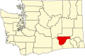
| State | Washington |
| County | Franklin |
| Elevation | 922 ft (281 m) |
| Time zone | UTC-8 (Pacific (PST)) |
| • Summer (DST) | UTC-7 (PDT) |
| Area code | 509 |
| GNIS feature ID | 1511023 [1] |
Harder is an unincorporated community in Franklin County, Washington, United States.