Fort Vancouver National Historic Site | |
---|---|
![]() Illustration of Fort Vancouver and its environs in 1855 | |
Location | Vancouver, Washington and Oregon City, Oregon, USA |
Nearest city | Vancouver, Washington, and Oregon City, Oregon |
Coordinates | 45°37′31″N122°39′29″W / 45.6253950°N 122.6581525°W [1] |
Area | 207 acres (84 ha) [2] |
Established | June 19, 1948 (national monument) June 30, 1961 (national historic site) |
Visitors | 710,439(in 2011) [3] |
Governing body | National Park Service |
Website | Fort Vancouver National Historic Site |
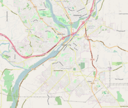
Fort Vancouver National Historic Site is a United States National Historic Site located in the states of Washington and Oregon. The National Historic Site consists of two units, one located on the site of Fort Vancouver in modern-day Vancouver, Washington; the other being the former residence of John McLoughlin in Oregon City, Oregon. The two sites were separately given national historic designation in the 1940s. [4] The Fort Vancouver unit was designated a National Historic Site in 1961, and was combined with the McLoughlin House into a unit in 2003.
The visitor center at Fort Vancouver National Historic Site was originally built in 1966 as a part of the National Park Service's Mission 66 Program. Today, the visitor center is co-operated by both the National Park Service and the United States Forest Service. Recent renovations to the visitor center (2015) transformed the historic building as an information center for both Fort Vancouver National Historic Site and the Gifford Pinchot National Forest. [5] The visitor center features rotating archaeological exhibits from the national historic site and art exhibits from local native artists. [6] The building also has a theater that shows 2 films from the National Park Service and the United States Forest Service: Oregon Experience: Fort Vancouver (25 mins), and Mount St. Helens - Eruption of Life (17 mins).
The main unit of the site, containing Fort Vancouver, is located in Vancouver, Washington, just north of Portland, Oregon. Fort Vancouver was an important Hudson's Bay Company (HBC) fur trading post that was established in 1824. Operations until 1845 were overseen by Chief Factor John McLoughlin. It was the headquarters of the Hudson's Bay Company's fur trade activity on the Pacific coast and its influence stretched from the Rocky Mountains in the east, to Alaska in the north, Alta California in the south, and to the Kingdom of Hawaii in the Pacific. Ratified in 1846, the Treaty of Oregon was signed by the United Kingdom of Great Britain and Ireland and the United States, thereby ending the decades long Oregon boundary dispute. The treaty permitted the Hudson's Bay Company to continue to operate at Fort Vancouver, which was now within the Oregon Territory. On June 14, 1860, Fort Vancouver was abandoned by the Hudson's Bay Company in favor of their stations in British Columbia, such as Fort Victoria.
Vancouver National Historic Reserve Historic District | |
![]() Pearson Hangar at Vancouver National Historic Reserve. | |
Location | Roughly bounded by an alley N of Officers' Row, East Reserve St., Columbia River, and I-5, Vancouver, Washington |
---|---|
Built | 1824 |
Architect | Hudson's Bay Co.; et al. |
Architectural style | Late Victorian, Late 19th And 20th Century Revivals |
NRHP reference No. | 06001216 |
Added to NRHP | January 5, 2007 [7] |
In 1849, the United States Army constructed the Vancouver Barracks adjacent to the British trading post; and took over the facility when it was abandoned. A fire destroyed the Hudson's Bay Company fort in 1866, but the Army facility continued in operation in various forms until the present. Fort Vancouver was separated from the Army's barracks and became a national monument in 1948. Congress expanded the protected area in 1966 and re-designated the site as a National Historic Site. For some years after its addition to the National Park System, the National Park Service was reluctant to begin reconstruction of the fort walls or buildings, preferring to manage it as an archaeological site as provided by its standing policies. However, in 1965, with the urging of the local community, Congress directed reconstruction to begin. All fort structures seen today are modern replicas, albeit carefully placed on the original locations. [8]
In response to concerns about the designation of reconstructed structures, the Park Service designated the Vancouver National Historic Reserve Historic District to encompass reconstructed buildings as well as historic Army and Mission 66-era Park Service structures. [9]
McLoughlin House National Historic Site | |
![]() | |
Location | McLoughlin Park, between 7th and 8th Sts., Oregon City, Oregon |
---|---|
Coordinates | 45°21′26″N122°36′21″W / 45.35722°N 122.60583°W |
Area | 0.6 acres (0.24 ha) |
Built | 1845 |
NRHP reference No. | 66000637 [10] |
Significant dates | |
Added to NRHP | October 15, 1966 |
Designated NHS | 1941 |
The McLoughlin House unit consists of the homes of McLoughlin and Dr. Forbes Barclay, an explorer and associate of McLoughlin's; the two homes are known respectively as the McLoughlin House and the Barclay House. They are located adjacent to each other on a bluff overlooking the Willamette River in Oregon City, Oregon, on a plot of land set aside for public use by McLoughlin in the 1840s. [11]
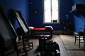
In 1846, McLoughlin left the employ of Hudson's Bay Company, and purchased from the company a land claim located on the Willamette River in Oregon City. McLoughlin constructed the house there, and lived there until his death in 1857. [12] The house, a two-style colonial mansion, is typical of East Coast residences from the time. [13]
After McLoughlin's death in 1857, his widow lived there until she died three years later; their heirs sold the house in 1867. The home soon became a bordello known as the Phoenix Hotel. In 1908, the paper mill that owned the property wished to expand and the house was threatened with demolition, but preservationists saved it the next year, raising over $1,000 and overcoming a referendum. [14] In 1910 the house was moved from the riverfront to its current location on a bluff overlooking downtown Oregon City. It sat there for twenty-five years, until being restored in 1935–1936 under the auspices of the Civil Works Administration, and opened as a museum. [13]
The Barclay House was built in 1849 by Portland carpenter and pioneer John L. Morrison, and occupied by Dr. Barclay and his family. Barclay died in 1874; the house remained in the family's possession until 1930 when it was moved from the waterfront to its present location, next to the McLoughlin House. Today, the Barclay House contains museum offices and a gift shop. [15]
The McLoughlin House became a National Historic Site in 1941, and both homes were added to the National Park System in 2003, becoming part of the Fort Vancouver National Historic Site. [12] [16] The McLoughlin House unit lies on the Oregon National Historic Trail, a part of the National Trails System. The graves of McLoughlin and his wife are on the premises. [17] The house contains both original and period furnishings.
Opened in a historic hangar in 1996, the Pearson Air Museum and The Jack Murdock Aviation Center showcases aviation history in the Vancouver area, and specifically Pearson Airfield. Today, the Pearson Air museum displays a number of aircraft, including a De Havilland DH-4 Liberty [18] that has been restored to represent an aircraft from the US Army Air Corps 321st Observation Squadron that was stationed at Pearson Airfield in the 1930s. In June 2018, National Park Service Volunteers completed work on a replica of Silas Christofferson's Curtis Pusher from scratch. The original plane was flown from the roof of the Multnomah Hotel in Portland, OR to the location of the modern day Pearson airfield. The replica is currently being exhibited at the Pearson Air Museum. Exhibits at the museum also feature the US Army Spruce Production Division, [19] and the first transpolar flight which landed in 1937 on Pearson Field from Moscow, Russia. Models of the Russian Tupolev ANT-25 that made the first transpolar flight are on display at the museum. [20]
An earth-covered pedestrian land bridge was built over the Lewis and Clark Highway, as part of the Confluence Project, in 2007. It connects the site with the Columbia River. [21]
Parts of the Vancouver Barracks were transferred to the National Park Service in 2012 when the US Army Reserve officially closed the post after its continuous occupation since 1849. The buildings are typically closed to the public, but there are outdoor exhibits. [22]
Since the Post to Park transfer to the National Park Service in 2012, the NPS has been restoring and renovating the barracks buildings to be used as mixed-use structures. Future tenants of these buildings are expected to be other governmental agencies, community groups, and private businesses. The area is expected to feature a community center, office buildings, restaurants, and retail in addition to a future museum space for the Vancouver Barracks operated by the National Park Service. In 2016, the Gifford Pinchot National Forest moved its headquarters and administration operations to one of the renovated double infantry barracks buildings in the Vancouver Barracks. [23] The United States Forest Service co-operates the visitor center on Fort Vancouver National Historic Site along with the National Park Service. [5]
A cross country running course is located at the site. The USA Cross Country Championships have been held at this site. [24]
John McLoughlin, baptized Jean-Baptiste McLoughlin, was a French-Canadian, later American, Chief Factor and Superintendent of the Columbia District of the Hudson's Bay Company at Fort Vancouver from 1824 to 1845. He was later known as the "Father of Oregon" for his role in assisting the American cause in the Oregon Country. In the late 1840s, his general store in Oregon City was famous as the last stop on the Oregon Trail.
The Presidio of San Francisco is a park and former U.S. Army post on the northern tip of the San Francisco Peninsula in San Francisco, California, and is part of the Golden Gate National Recreation Area.
Fort Vancouver was a 19th-century fur trading post built in the winter of 1824–1825. It was the headquarters of the Hudson's Bay Company's Columbia Department, located in the Pacific Northwest. Named for Captain George Vancouver, the fort was located on the northern bank of the Columbia River in present-day Vancouver, Washington. The fort was a major center of the regional fur trading. Every year trade goods and supplies from London arrived either via ships sailing to the Pacific Ocean or overland from Hudson Bay via the York Factory Express. Supplies and trade goods were exchanged with a plethora of Indigenous cultures for fur pelts. Furs from Fort Vancouver were often shipped to the Chinese port of Guangzhou where they were traded for Chinese manufactured goods for sale in the United Kingdom. At its pinnacle, Fort Vancouver watched over 34 outposts, 24 ports, six ships, and 600 employees. Today, a full-scale replica of the fort, with internal buildings, has been constructed and is open to the public as Fort Vancouver National Historic Site.
Fort Concho is a former United States Army installation and National Historic Landmark District located in San Angelo, Texas. It was established in November 1867 at the confluence of the North and South Concho Rivers, on the routes of the Butterfield Overland Mail Route and Goodnight–Loving Trail, and was an active military base for the next 22 years. Fort Concho was the principal base of the 4th Cavalry from 1867 to 1875 and then the "Buffalo Soldiers" of the 10th Cavalry from 1875 to 1882. The troops stationed at Fort Concho participated in Ranald S. Mackenzie's 1872 campaign, the Red River War in 1874, and the Victorio Campaign of 1879–1880.
Klondike Gold Rush National Historical Park is a national historical park operated by the National Park Service that seeks to commemorate the Klondike Gold Rush of the late 1890s. Though the gold fields that were the ultimate goal of the stampeders lay in Yukon, the park comprises staging areas for the trek there and the routes leading in its direction. There are four units, including three in Municipality of Skagway Borough, Alaska and a fourth in the Pioneer Square National Historic District in Seattle, Washington.
Valley Forge National Historical Park is the site of the third winter encampment of the Continental Army during the American Revolutionary War from December 19, 1777 to June 19, 1778. The National Park Service preserves the site and interprets the history of the Valley Forge encampment. The park contains historical buildings, recreated encampment structures, memorials, museums, and recreation facilities.
San Juan Island National Historical Park, also known as American and English Camps, San Juan Island, is a US National Historical Park owned and operated by the National Park Service on San Juan Island in the state of Washington. The park is made up of the sites of the British and U.S. Army camps during the Pig War, a boundary dispute over the ownership of the island. The camp sites were designated a National Historic Landmark in 1961, and listed on the National Register of Historic Places in 1966. The park was created by an act of Congress in 1966 and expanded slightly in 2013.
San Juan National Historic Site in the Old San Juan section of San Juan, Puerto Rico, is a National Park Service-managed historic site which preserves and interprets the Spanish colonial-era fortification system of the city of San Juan, and features structures such as the San Felipe del Morro and San Cristóbal fortresses. This fortification system is the oldest European construction under United States jurisdiction and one of the oldest in the New World. This national historic site, together with La Fortaleza, have been designated a UNESCO World Heritage Site since 1983.
The trade center Fort Colvile was built by the Hudson's Bay Company (HBC) at Kettle Falls on the Columbia River in 1825 and operated in the Columbia fur district of the company. Named for Andrew Colvile, a London governor of the HBC, the fort was a few miles west of the present site of Colville, Washington. It was an important stop on the York Factory Express trade route to London via the Hudson Bay. The HBC for some time considered Fort Colvile second in importance only to Fort Vancouver, near the mouth of the Columbia, until the foundation of Fort Victoria.
The Richmond National Battlefield Park commemorates 13 American Civil War sites around Richmond, Virginia, which served as the capital of the Confederate States of America for most of the war. The park connects certain features within the city with defensive fortifications and battle sites around it.
The Pearson Air Museum is a place-based aviation museum at Pearson Field in Vancouver, Washington, USA. Managed by the National Park Service as part of the Fort Vancouver National Historic Site, museum exhibits provide an opportunity for visitors to explore aviation history tied to Pearson Field and Vancouver Barracks. Objects and artifacts from the National Park Service collections and on loan from members of the community and other museums depict history of aviation in the Pacific Northwest.
Fort Boise is either of two different locations in the Western United States, both in southwestern Idaho. The first was a Hudson's Bay Company (HBC) trading post near the Snake River on what is now the Oregon border, dating from the era when Idaho was included in the British fur company's Columbia District. After several rebuilds, the fort was ultimately abandoned in 1854, after it had become part of United States territory following settlement in 1846 of the northern boundary dispute.
Fort Klamath was a military outpost near the western end of the Oregon Trail, between Crater Lake National Park and Upper Klamath Lake in Klamath County, Oregon, United States. The Fort Klamath Site, about a mile southeast of the present community of Fort Klamath, Oregon, is listed on the U.S. National Register of Historic Places
The Vancouver Barracks was the first United States Army base located in the Pacific Northwest, established in 1849, in what is now contemporary Vancouver, Washington. It was built on a rise 20 feet (6.1 m) above the Fort Vancouver fur trading station established by the Hudson's Bay Company (HBC). Its buildings were formed in a line adjacent to the Columbia River approximately 2,000 yards (1,800 m) from the riverbank.
Vancouver is a city on the north bank of the Columbia River in the U.S. state of Washington, located in Clark County. Founded in 1825 and incorporated in 1857, Vancouver had a population of 190,915 as of the 2020 census, making it the fourth-most populous city in Washington state. Vancouver is the seat of government of Clark County and forms part of the Portland-Vancouver metropolitan area, the 25th-largest metropolitan area in the United States. Originally established in 1825 around Fort Vancouver, a fur-trading outpost, the city is located on the Washington–Oregon border along the Columbia River, directly north of Portland.
Pearson Field also once known as Pearson Airpark, is a city-owned municipal airport located one mile (2 km) southeast of the central business district of Vancouver, a city in Clark County, Washington, United States.
Fort Cronkhite is one of the components of California's Golden Gate National Recreation Area. Today part of the National Park Service, Fort Cronkhite is a former US Army post that served as part of the coastal artillery defenses of the San Francisco Bay Area during World War II. The soldiers at Cronkhite manned gun batteries, radar sites, and other fortifications on the high ridges overlooking the fort.
The Education Center on Pearson Field, formerly Pearson Field Education Center (PFEC) is an educational facility for young people ages kindergarten through 12th grade (K-12). It is located in Pearson Field, Vancouver, Washington. The center provides programs in aviation-based science, technology, engineering, and math (STEM).
The McLoughlin Promenade is a scenic pathway located on Singer Hill Bluff, on the southeast bank of the Willamette River overlooking Oregon City in the U.S. state of Oregon. It was constructed 1936–1939 on land once inhabited by the Molala and other indigenous peoples. Named after Oregon pioneer John McLoughlin who donated his personal real estate for the purpose of a city promenade, the design and implementation of it was part of a joint public works effort between Oregon and the United States government. The pathway courses 100 feet (30 m) above Oregon City and features the Grand Staircase and the man-made Singer Creek Falls. Lighting was added by the local Kiwanis club in 1972, and the Lee Kelly Moontrap bas-relief addition at the bottom of the falls was sponsored by the Rotary Club in 2011.