Sycan River

Last updated
Sycan River
Sycan Marsh.jpg
Aerial view of Sycan Marsh
Name origin:after Sycan Marsh, from the Klamath words saiga and keni, meaning level, grassy place [1]
Country United States
State Oregon
County Lake and Klamath
Sourcesouth of Slide Mountain and Summer Lake
 - location Fremont National Forest, Lake County
 - coordinates 42°38′50″N120°44′08″W / 42.64722°N 120.73556°W / 42.64722; -120.73556   [2]
Mouth Sprague River
 - locationnear Beatty, Klamath County
 - elevation4,311 ft (1,314 m) [2]
 - coordinates 42°27′40″N121°17′13″W / 42.46111°N 121.28694°W / 42.46111; -121.28694 Coordinates: 42°27′40″N121°17′13″W / 42.46111°N 121.28694°W / 42.46111; -121.28694   [2]
Length75 mi (121 km) [3]
Basin559 sq mi (1,447.8 km2) [4]
Discharge
 - average149 cu ft/s (4 m3/s) [5]
 - min1 cu ft/s (0 m3/s)
Wpdms shdrlfi020l sprague river.jpg
Map of Sycan River region
USA Oregon location map.svg
Red pog.svg
Location of the mouth of the Sycan River in Oregon
TypeScenic, Recreational
DesignatedOctober 28, 1988

The Sycan River is a tributary, about 75 miles (121 km) long, of the Sprague River in the U.S. state of Oregon. [3] The headwaters are in highlands in the Fremont National Forest south of Summer Lake. [6] The river runs northwest into the Sycan Marsh in southern Lake County, from which it flows generally southwest to join the Sprague River near Beatty, in Klamath County. [6] The uppermost 59 miles (95 km) of the stream are part of the National Wild and Scenic Rivers System. [7]

Sprague River (Oregon) river in the United States of America

The Sprague River is a tributary of the Williamson River, approximately 75 miles (121 km) long, in southwestern Oregon in the United States. It drains an arid volcanic plateau region east of the Cascade Range in the watershed of the Klamath River.

U.S. state constituent political entity sharing sovereignty as the United States of America

In the United States, a state is a constituent political entity, of which there are currently 50. Bound together in a political union, each state holds governmental jurisdiction over a separate and defined geographic territory and shares its sovereignty with the federal government. Due to this shared sovereignty, Americans are citizens both of the federal republic and of the state in which they reside. State citizenship and residency are flexible, and no government approval is required to move between states, except for persons restricted by certain types of court orders. Four states use the term commonwealth rather than state in their full official names.

Oregon State of the United States of America

Oregon is a state in the Pacific Northwest region on the West Coast of the United States. The Columbia River delineates much of Oregon's northern boundary with Washington, while the Snake River delineates much of its eastern boundary with Idaho. The parallel 42° north delineates the southern boundary with California and Nevada. Oregon is one of only three states of the contiguous United States to have a coastline on the Pacific Ocean.

Contents

Course

Near its headwaters, the Sycan River, flowing west, receives Boulder Creek from the right and the South Fork Sycan River from the left. The Hanan Trail, a hiking path, runs roughly parallel to the river along this stretch, which is part of the National Wild and Scenic Rivers System. Turning northwest, the Sycan receives Rock, Kelly, and Nixon creeks from the right before turning west again. Over the next stretch, Cummings Creek enters from the right, Rifle Creek from the left, and the Sycan leaves Lake County and enters Klamath County. Skull Creek then enters from the left and Currier Creek from the right. [6]

Downstream of Currier Creek, Paradise Creek enters from the left, and the Sycan turns northwest and then north, leaving Klamath County and re-entering Lake County. Slightly north of the border, Long Creek enters from the right. After turning west and southwest, [6] the river enters Sycan Marsh, a wetland of about 50 square miles (130 km2). [8] Continuing southwest through the marsh, the river leaves Lake County and re-enters Klamath County. Further downstream, Merritt Creek enters from the left. Meandering west and then south, the Sycan receives Blue Creek from the left, enters Sprague River Valley, receives Snake Creek from the left, and enters the Sprague River north of Beatty. [6]

Wetland A land area that is permanently or seasonally saturated with water

A wetland is a distinct ecosystem that is inundated by water, either permanently or seasonally, where oxygen-free processes prevail. The primary factor that distinguishes wetlands from other land forms or water bodies is the characteristic vegetation of aquatic plants, adapted to the unique hydric soil. Wetlands play a number of functions, including water purification, water storage, processing of carbon and other nutrients, stabilization of shorelines, and support of plants and animals. Wetlands are also considered the most biologically diverse of all ecosystems, serving as home to a wide range of plant and animal life. Whether any individual wetland performs these functions, and the degree to which it performs them, depends on characteristics of that wetland and the lands and waters near it. Methods for rapidly assessing these functions, wetland ecological health, and general wetland condition have been developed in many regions and have contributed to wetland conservation partly by raising public awareness of the functions and the ecosystem services some wetlands provide.

Recreation

The river supports rainbow, brook, brown, and bull trout. The upper river offers good fly fishing for small brook trout, while brown trout are found only in the lower river downstream of the marsh. Rough forest roads provide access to parts of the lightly fished river. The lower 12 miles (19 km) is generally bordered by privately owned land, where permission is needed for access. [9]

Rainbow trout species of trout

The rainbow trout is a trout and species of salmonid native to cold-water tributaries of the Pacific Ocean in Asia and North America. The steelhead is an anadromous (sea-run) form of the coastal rainbow trout(O. m. irideus) or Columbia River redband trout (O. m. gairdneri) that usually returns to fresh water to spawn after living two to three years in the ocean. Freshwater forms that have been introduced into the Great Lakes and migrate into tributaries to spawn are also called steelhead.

Brook trout species of fish

The brook trout is a species of freshwater fish in the char genus Salvelinus of the salmon family Salmonidae. It is native to Eastern North America in the United States and Canada, but has been introduced elsewhere in North America, as well as to Iceland, Europe, and Asia. In parts of its range, it is also known as the eastern brook trout, speckled trout, brook charr, squaretail, or mud trout, among others. A potamodromous population in Lake Superior, as well as an anadromous population in Maine, is known as coaster trout or, simply, as coasters. The brook trout is the state fish of nine U.S. states: Michigan, New Hampshire, New Jersey, New York, North Carolina, Pennsylvania, Vermont, Virginia, and West Virginia, and the Provincial Fish of Nova Scotia in Canada.

Brown trout species of brown trout

The brown trout is a European species of salmonid fish that has been widely introduced into suitable environments globally. It includes both purely freshwater populations, referred to as the riverine ecotype, Salmo trutta morpha fario, and a lacustrine ecotype, S. trutta morpha lacustris, also called the lake trout, as well as anadromous forms known as the sea trout, S. trutta morpha trutta. The latter migrates to the oceans for much of its life and returns to fresh water only to spawn. Sea trout in the Ireland and Britain have many regional names: sewin in Wales, finnock in Scotland, peal in the West Country, mort in North West England, and white trout in Ireland.

The Nature Conservancy, a nonprofit organization that owns most of the Sycan Marsh and some of the surrounding forest, offers self-guided automobile tours of the marsh. No hunting, fishing, camping, or pets are allowed in the preserve, which has no services and few opportunities for hiking. However, the marsh, attracting thousands of migrating tundra swans, sandhill cranes, yellow rails, black tern, white-faced ibises, and other species, offers opportunities for bird-watching. Access to the preserve is by unpaved forest roads. [10]

The Nature Conservancy organization

The Nature Conservancy (TNC) is a charitable environmental organization, headquartered in Arlington, Virginia, United States.

Tundra swan species of bird

The tundra swan is a small Holarctic swan. The two taxa within it are usually regarded as conspecific, but are also sometimes split into two species: Bewick's swan of the Palaearctic and the whistling swan proper of the Nearctic. Birds from eastern Russia are sometimes separated as the subspecies C. c. jankowskii, but this is not widely accepted as distinct, with most authors including them in C. c. bewickii. Tundra swans are sometimes separated in the subgenus Olor together with the other Arctic swan species.

Sandhill crane species of bird

The sandhill crane is a species of large crane of North America and extreme northeastern Siberia. The common name of this bird refers to habitat like that at the Platte River, on the edge of Nebraska's Sandhills on the American Plains. This is the most important stopover area for the nominotypical subspecies, the lesser sandhill crane, with up to 450,000 of these birds migrating through annually.

See also

Related Research Articles

Deschutes River (Oregon) river in the United States of America

The Deschutes River in central Oregon is a major tributary of the Columbia River. The river provides much of the drainage on the eastern side of the Cascade Range in Oregon, gathering many of the tributaries that descend from the drier, eastern flank of the mountains. The Deschutes provided an important route to and from the Columbia for Native Americans for thousands of years, and then in the 19th century for pioneers on the Oregon Trail. The river flows mostly through rugged and arid country, and its valley provides a cultural heart for central Oregon. Today the river supplies water for irrigation and is popular in the summer for whitewater rafting and fishing.

Sandy River (Oregon) tributary of the Columbia River in northwestern Oregon in the United States

The Sandy River is a 56-mile (90 km) tributary of the Columbia River in northwestern Oregon in the United States. The Sandy joins the Columbia about 14 miles (23 km) upstream of Portland.

Clackamas River tributary of the Willamette River in Oregon

The Clackamas River is an approximately 83-mile (134 km) tributary of the Willamette River in northwestern Oregon, in the United States. Draining an area of about 940 square miles (2,435 km2), the Clackamas flows through mostly forested and rugged mountainous terrain in its upper reaches, and passes agricultural and urban areas in its lower third. The river rises in eastern Marion County, about 55 miles (89 km) east-southeast of Salem. The headwaters are on the slopes of Olallie Butte in the Mount Hood National Forest, about 10 miles (16 km) north of Mount Jefferson, at an elevation of 4,909 feet (1,496 m) in the Cascade Range. The Clackamas flows briefly north and then flows northwest through the mountains, passing through North Fork Reservoir and Estacada. It then emerges from the mountains southeast of Portland. It joins the Willamette near Oregon City and forms the boundary between Oregon City and Gladstone.

Bly, Oregon Unincorporated community in Oregon, United States

Bly is an unincorporated small town in Klamath County, Oregon, United States. By highway, it is about 50 miles (80 km) east of Klamath Falls. As of 2000, the population was 486.

Williamson River (Oregon) river in the United States of America

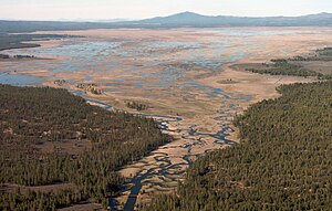
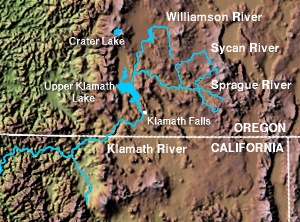
The Williamson River of south-central Oregon in the United States is about 100 miles (160 km) long. It drains about 3,000 square miles (7,800 km2) east of the Cascade Range. Together with its principal tributary, the Sprague River, it provides over half the inflow to Upper Klamath Lake, the largest freshwater lake in Oregon. The lake's outlet is the Link River, which flows into Lake Ewauna and the Klamath River.

Lost River (California) river in the United States of America

Lost River begins and ends in a closed basin in northern California and southern Oregon in the United States. The river, 60 miles (97 km) long, flows in an arc from Clear Lake Reservoir in Modoc County, California, through Klamath County, Oregon, to Tule Lake in Siskiyou County, California. About 46 mi (74 km) of Lost River are in Oregon, and 14 miles (23 km) are in California.

OC&E Woods Line State Trail

The OC&E Woods Line State Trail is a rail trail in Klamath and Lake counties in the U.S. state of Oregon. It is Oregon's longest state park. The trail follows the old OC&E and Weyerhaeuser railroads from Klamath Falls to Thompson Reservoir. Along its 105-mile (169 km) length it passes through the communities of Olene, Sprague River, Dairy, Beatty, and Bly.

Klamath Basin

The Klamath Basin is the region in the U.S. states of Oregon and California drained by the Klamath River. It contains most of Klamath County and parts of Lake and Jackson counties in Oregon, and parts of Del Norte, Humboldt, Modoc, Siskiyou, and Trinity counties in California. The 15,751-square-mile (40,790 km2) drainage basin is 35% in Oregon and 65% in California. In Oregon, the watershed typically lies east of the Cascade Range, while California contains most of the river's segment that passes through the mountains. In the Oregon-far northern California segment of the river, the watershed is semi-desert at lower elevations and dry alpine in the upper elevations. In the western part of the basin, in California, however, the climate is more of temperate rainforest, and the Trinity River watershed consists of a more typical alpine climate.

Umatilla River tributary of the Columbia River in Oregon

The Umatilla River is an 89-mile (143 km) tributary of the Columbia River in the U.S. state of Oregon. Draining a basin of 2,450 square miles (6,300 km2), it enters the Columbia near the city of Umatilla in the northeastern part of the state. In downstream order, beginning at the headwaters, major tributaries of the Umatilla River are the North Fork Umatilla River and the South Fork Umatilla River, then Meacham, McKay, Birch, and Butter creeks.

Crooked River (Oregon) tributary of the Deschutes River in the U.S. state of Oregon

The Crooked River is a tributary, 125 miles (201 km) long, of the Deschutes River in the U.S. state of Oregon. The river begins at the confluence of the South Fork Crooked River and Beaver Creek. Of the two tributaries, the South Fork Crooked River is the larger and is sometimes considered part of the Crooked River proper. A variant name of the South Fork Crooked River is simply "Crooked River". The Deschutes River flows north into the Columbia River.

Quartzville Creek tributary of the Middle Santiam River in Oregon

Quartzville Creek is a 28-mile (45 km) tributary of the Middle Santiam River in Linn County in the U.S. state of Oregon. It is paralleled by the Quartzville Back Country Byway and used for recreation, including camping, fishing, hunting, kayaking, and gold panning. The lower 12 miles (19 km) of the creek, from the Willamette National Forest boundary to Green Peter Reservoir, was designated Wild and Scenic in 1988.

Course of the Rogue River (Oregon) river in the United States of America

The Rogue River in the U.S. state of Oregon begins at Boundary Springs on the border between Klamath and Douglas counties near the northern edge of Crater Lake National Park. The Rogue River flows generally west for 215 miles (346 km) from the Cascade Range through the Rogue River – Siskiyou National Forest and the Klamath Mountains to the Pacific Ocean at Gold Beach. Communities along its course include Union Creek, Prospect, Trail, Shady Cove, Gold Hill, and Rogue River, all in Jackson County; Grants Pass, and Galice in Josephine County, and Agness, Wedderburn and Gold Beach in Curry County. Significant tributaries include the South Fork Rogue River, Elk Creek, Bear Creek, the Applegate River, and the Illinois River. Arising at 5,320 feet (1,622 m) above sea level, the river loses more than 1 mile (1.6 km) in elevation by the time it reaches the Pacific.

South Fork Rogue River tributary of the Rogue River in Oregon

The South Fork Rogue River is a 25-mile (40 km) tributary of the Rogue River in the U.S. state of Oregon. Rising in the Sky Lakes Wilderness in the Cascade Range, it flows generally northeast through the Rogue River – Siskiyou National Forest to meet the Rogue River downstream of Prospect and slightly upstream of Lost Creek Lake.

The Klamath River is a river in southern Oregon and northern California in the United States. This article describes its course.

North Fork Malheur River river in the United States of America

The North Fork Malheur River is a 59-mile (95 km) tributary of the Malheur River in eastern Oregon in the United States. Rising in Big Cow Burn in the Blue Mountains, it flows generally south to join the larger river at Juntura. The upper 25.5 miles (41.0 km) of the river have been designated Wild and Scenic. This part of the river basin offers camping, hiking, and fishing opportunities in a remote forest setting. The lower river passes through Beulah Reservoir, which stores water for irrigation and has facilities for boaters.

Union Creek (Rogue River)

Union Creek is a 15-mile (24 km) long tributary of the Rogue River in the U.S. state of Oregon. Beginning west of Union Peak in the Cascade Range, it flows through the Rogue River – Siskiyou National Forest to meet the Rogue at Union Creek and the Union Creek Historic District.

Pistol River river in the United States of America

The Pistol River is a coastal stream that meanders for 21 miles (34 km) through the Southern Oregon Coast Range to the Pacific Ocean near the unincorporated community of Pistol River in the U.S. state of Oregon. Flowing generally southwest from its origin near Sugarloaf Mountain in the Siskiyou National Forest, the river enters the sea at Pistol River State Scenic Viewpoint, 10 miles (16 km) south of Gold Beach. The river received its name after pioneer James Mace lost his pistol in it in 1853.

Winchuck River river in the United States of America

The Winchuck River is a short coastal stream that runs through the Rogue River–Siskiyou National Forest to the Pacific Ocean in the U.S. states of Oregon and California. Flowing generally west from its origin near Elk Mountain, the river enters the sea at Crissey Field State Recreation Site, about 12 mile (0.80 km) north of the Oregon–California border and about 5 miles (8 km) south of Brookings.

South Fork McKenzie River tributary of the McKenzie River in Oregon

The South Fork McKenzie River is a tributary, about 31 miles (50 km) long, of the McKenzie River in the U.S. state of Oregon. It begins at about 4,500 feet (1,400 m) above sea level near Mink Lake in the Three Sisters Wilderness of the Cascade Range. Flowing northwest within Lane County, it meets the McKenzie River about 60 miles (97 km) from the larger river's confluence with the Willamette River.

References

  1. McArthur, pp. 93031
  2. 1 2 3 "Sycan River". Geographic Names Information System. United States Geological Survey. November 28, 1980. Retrieved April 7, 2011.
  3. 1 2 "National Hydrography Dataset". United States Geological Survey. Retrieved March 9, 2011.
  4. "Lower Sycan Watershed Analysis" (PDF). United States Forest Service. 2005. p. 2. Retrieved April 7, 2011.
  5. Palmer, Tim (2014). Field Guide to Oregon Rivers. Corvallis: Oregon State University Press. p. 239. ISBN   978-0-87071-627-0.
  6. 1 2 3 4 5 United States Geological Survey. "United States Geological Survey Topographic Map". TopoQuest. Retrieved April 8, 2011. The relevant map quadrangles from mouth to source are Beatty, Spodue Mountain, Riverbed Butte Spring, Sycan Marsh West, Sycan Marsh East, Pole Butte, Riverbed Butte, Shake Butte, Harvey Creek, and Slide Mountain.
  7. "Sycan River, Oregon". National Wild and Scenic Rivers System. Retrieved December 19, 2013.
  8. "Sycan Marsh Preserve". The Nature Conservancy. Retrieved April 8, 2011.
  9. Sheehan, p. 292
  10. "Discover Sycan Marsh" (PDF). The Nature Conservancy. 2005. Retrieved April 8, 2011.

Works cited