Fremont National Forest

Last updated

The Fremont-Winema National Forest of south central Oregon is a mountainous region with a rich geological, ecological, archaeological, and historical history. Founded in 1908, the Fremont National Forest was originally protected as the Goose Lake Forest Reserve in 1906. The name was soon changed to Fremont National Forest, named after John C. Frémont, who explored the area for the United States Army Corps of Engineers in 1843. It absorbed part of Paulina National Forest on July 19, 1915. In 2002, it was administratively combined with the Winema National Forest as the Fremont–Winema National Forests.

Contents

Geography

The Fremont National Forest is the eastern portion of the Fremont-Winema National Forest, which combined comprises a significant portion of south-central Oregon. Yamsay Mountain is located in the extreme north-northwest of the forest region. The Winema portion includes Crater Lake and the eastern slopes of the Cascade Mountains. The Fremont portion includes an area that begins on the shores of Klamath Marsh in the west, Hagger Mountain in the north, Winter Rim on the east, and down to the California border between near Lakeview, Oregon. This area of Oregon region is nicknamed the ‘pumice plains’, referring to the area having borne the brunt of tephra deposition during the eruption of Mount Mazama (Crater Lake) in 7,620 BP.

The climate is significantly drier on the east side of the Cascades, resulting in a rainshadow effect. This difference in precipitation between the lower and higher elevations of forested areas spans two Köppen climate classifications. The majority of the Fremont is Csb: warm summer Mediterranean, whereas elevations of 7,000 feet and higher are designated as Dsc: dry summer subarctic, [1] (Climate Data.org 2016). Precipitation primarily in the form of winter rains and snow pack feed watersheds that include perennial and annual creeks, fen marshes, and small lakes. Perennial rivers include the Chewaucan, Sprague, Williamson, and Sycan. Generally the landscape is relatively flat and rolling, although there are some high peaks that include Yamsay Mountain at 8,196 feet above sea level, and 8,370 foot Gearhart Mountain. Both are volcanic in origin but formed during events separate from what formed the nearby Cascade Range.

Geology

The volcanoes of the Fremont Forest are typically older than the Cascades and were a result of tectonic shearing stretching the crust thin which allowed mantle magma to emerge at the surface. [2] Crustal stretching continued through the late Miocene resulting in uplifted fault blocking of what was flat basalt landscapes, creating into towering scarp- mountains that are gently sloped on one side and terminate into a sharp scarp face on the other. [2] The east portion of the Fremont Forest region is like this, sloping to the west and terminating in a sheer scarp face along the Summer Lake sub-basin.

Archaeological & ethnographic history

Elder Klamath woman, 1924 Edward S. Curtis Collection People 086.jpg
Elder Klamath woman, 1924

Human presence in the Fremont region extends back thousands of years. Physical evidence of this comes from the Paisley Caves (location of the discovery of a 14,500 year old human coprolite [3] ) Fort Rock Cave (the location of the now famous ‘oldest shoes in the world’ sagebrush sandals [4] ), and more recently, Connley Caves (where bison remains and delicate Ice Age bone needles have been found and dated to well over 10k years old [5] ). These sites are within 10 to 20 miles from the Fremont Forest boundary. Further archaeological evidence of later human activity can be found at Carlon Village and Picture Rock Pass, and many more smaller house rings and artifact scatters throughout the area. Through clear cultural relationships seen in the artifact record, as well as legends and oral knowledge tying them to this place, the decedents of these early people are the Klamath. The Paiute and Modoc also have a long and rich cultural connection to the Fremont Forest.

Native people were quickly moved out of their traditional territories through the late 1800s into the mid-1900s as a response to Euro-American settlers in the region that were attracted to rich forest resources and ranching possibilities. The exception was Yamsay Mountain which remained part of the 1901 Klamath Reservation until 1911 when it became listed as part of the Paulina National Forest and was later ceded to the Fremont National Forest in 1913. [6] The Klamath tried to recover their previous lands, but in 1954 the Klamath Termination Act meant that the tribe's remaining 525,700 acres of former Indian reservation lands, almost all within the Fremont Forest region, were placed under National Forest administration under the 1953 House Concurrent Resolution 108 (HCR-108). Klamath tribal designation was restored in 1986 [1].

Euro-American arrival

Euro-American traders began entering the Klamath area at some point between 1825 and 1827, where they worked as trappers for the Hudson's Bay Company. [7] The Fremont National Forest was established in 1908 and was named for Captain John C. Fremont, who was sent to explore the area in 1843. After trade routes inland and to the Pacific were opened up in 1846, Fort Klamath was built in 1863 and the Klamath reservation was established. In the beginning the Klamath were able to keep Yamsay Mountain in their territory, but vast economic opportunities present was too much for the federal government to resist. Trappers may have begun the early movements of Euro-Americans into the area, but it was the harvesting of old growth ponderosa pine timber that was the real draw later in the 19th century. Ecological damage done by excessive logging was exacerbated by the introduction of sheep and cattle ranching, complete fire suppression, and other activities which remain visible on the landscape to this day.

Ecology

Drews Creek, Fremont National Forest Drews Creek, Fremont National Forest, Oregon.jpg
Drews Creek, Fremont National Forest

The Fremont Forest region is listed as part of the Mazama ecoregion due to high amounts of Mazama tephra covering the landscape as a result of its catastrophic eruption 7,620 years ago that resulted in the formation of Crater Lake. [8] [9] Fremont ecology is at once fragile and robust, with dominant trees including ponderosa and lodgepole pines, juniper, willow in wetter areas, and occasional firs in some higher elevations [10] as well as over 925 vascular plant species. [11] Examples of herbaceous plants and shrubs include Nootka rose, biscuit roo t, bitterroot, ipos (wild carrot), gooseberries, service berries, wild strawberries, lily bulbs, and, in wetter areas, camas, wokus (yellow pond lily), and cattails. [12] [13] [11] The Fremont area differs from the Winema area in that it has slightly less tree diversity. This is due to two primary factors: the Cinema encompasses a greater elevation range, and receives more precipitation, due to its location on the east slopes of the Cascades, which provides alpine and subalpine environments.

Fauna includes deer, elk, black bears, coyotes, badgers, many types of rodents, jackrabbits and rabbits, cougars, bobcats, porcupines, Reptiles and amphibians. Endangered endemic fauna includes the Larch Mountain salamander (Plethodon larselli), a rare, lungless amphibian that lives on steep talus slopes. [14] Golden and bald eagles are permanent fixtures, as well as hawks, herons, sandhill cranes, and many migratory birds that move along the Pacific flyway.

Fire ecology

Burned ponderosa pine from 2012 Barry Point Fire. Photo taken on road to Dog Lake. Road to Dog Lake 09-2017.jpg
Burned ponderosa pine from 2012 Barry Point Fire. Photo taken on road to Dog Lake.

Fire is a necessary component to the health and structure of a meso-xeric landscape forest structure. State, federal, and tribal land managers recognize this and are moving research and implementation of fire regimes along quickly in order to minimize possible future threats to forest, water resources, human health and properties.

An assessment of prehistoric forest composition will be of benefit to understanding how climate change might affect future forest structure and thus, better informed management. The genera described below are primary forest structure trees as listed by which trees make up the primary composition of the Fremont forest. This list comes from a combination of primary literature that includes academic studies as well as forestry reports and genera surveys.

Forest zones east of the Cascades are generally defined as being Rocky Mountain forest types. [15] The Fremont is on the boundary of the floristic Great Basin and reflects this with the presence of typical Great Basin flora, including sagebrush (Artemisia sp.) and bitterbrush (Purshia sp.). The dominant conifer species is ponderosa pine (Pinus ponderosa). Current ecological structures are the result of 100 years of fire suppression.

Shrub-steppe flora of the Basin and Range mix with ponderosa pine communities. Fire is a natural and regular occurrence in this region, which is reflected in the flora and fauna evolved to make use of cyclical fire regimes [16] [17] and species distributions are rapidly affected depending on the presence or lack of fire cycles.

Tree species of Fremont National Forest

SpeciesAutecology
Ponderosa pine (Pinus ponderosa) The dominant conifer species of the east of the Cascade Range. Ponderosas range in height of mature trees range up to 232 feet in height, diameter trunks range from 30 to 50 inches and can live from 300 to 600 years. [18] Fire is a critical component to the ponderosa lifecycle. Ponderosas have thick bark that allows for low intensity fires to burn without damaging the inner cambium, have relatively light lichen cover to also reduce fire fuels on their trunks, drop their lower branches as they mature, reducing possibility of fuel for fire to reach the open canopy, and have high moisture content within their leaves. Ponderosa also have deep roots that can escape most fire damage. Seedlings thrive and grow quickly in mineral-rich soils left behind by fires. Ponderosa do not thrive in shaded areas, and therefore can be out-competed by fast growing, shade-tolerant tree species. Their cones are not considered serotinous [19] fire dependent for opening to drop seeds. Fire shapes the composition of ponderosa forests. Early Euro-Americans reported open parklands in the 1800s with relatively little fuel (smaller trees, shrubs) in the understory. However, since fire suppression efforts began in the 1800s, potential fire fuels increased greatly and rapidly, resulting in an increased risk of high intensity, stand-replacing fires. Fire kills ponderosa saplings that have not matured enough to develop their fire defenses, which is what traditionally led to well-spaced mature trees, which have a higher survival rate due to these fire adaptations. The primary threat of fire to a mature ponderosa is crown scorch.
Lodgepole pine (Pinus contorta) This species exists in various areas throughout the Fremont forest region, particularly at higher elevations and in areas with thick deposits of Mazama tephra. P. contorta is a successional conifer, meaning that it rapidly colonizes disturbed areas, but is also highly shade and fire intolerant. They grow 40–150 feet in height, with a trunk diameter not exceeding 30 inches and can live 150–200 years. Evolutionarily they seem to have traded speed in growth and regeneration over longevity and fire hardiness. Lodgepole pines can rapidly move into disturbed areas which may be due to a variable rooting system that can take advantage of deep or shallow soils. There is evidence that they may fix nitrogen with their root systems. [20] Although lodgepole is fire sensitive, lodgepole cones are often serotinous, releasing seed after fire. They are also highly susceptible to insect infestations and disease, particularly lodgepole pine dwarf-mistletoe (Arceuthobium americanum), all of which can alter and increase the amount and spatial distribution of fuels in lodgepole pine stands which can result in stand-replacing fires. [21]
Jeffrey pine (Pinus jeffreyi) This species is present in much of the area dividing the Fremont section from the Winema section. In these areas, it is often a dominant species. [22] However, in sites with more nutrient rich soils and in mixed-conifer forests, Jeffrey pine's dominance is dependent on recurrent fire. Without fire or other disturbances that create gaps in the canopy, Jeffrey pine is often replaced by more shade-tolerant conifers such as white fir (Abies concolor). [23] Its possible that many of the white fir in lower elevations of the eastern Cascades have replaced Jeffrey pine stands as a result of fire suppression.
Juniper (Juniperus occidentalis) Juniper is endemic to this region but highly fire intolerant. Because of fire suppression juniper is beginning to outcompete and dominate many areas within the Fremont Forest and other areas in the Great Basin. [24] Burning kills western juniper and temporarily produces herbaceous or shrubland communities, but these are typically reinvaded by junipers. Juniper is also a sparely spaced tree that outcompetes other plants, including other junipers, by dropping needles that make it near impossible for new plants to be able to grow. Aggressively invasive cheatgrass (Bromus tectorum) is typically able to deal with the hostile environment created by junipers, and so out also outcompetes native forbs and grasses and increases risk of fire spread. [25]

Balance between fire suppression and prescribed burning

The suppression of fire for the last 100 years within the Fremont has resulted in an increase in fuel loads that lead to too hot forest fires that kill the plants evolved to depend on recurrent fire or create stands of shade-tolerant trees replacing shade-intolerant species, thus altering the structure of the ecosystem. This stand structures can lead to more intense fires, given the right fuel moisture and wind conditions, due to an increase in understory and smaller trees growing closer together. This may also increase susceptibility to disease and insect outbreaks. These results have led to loss of natural diversity, and an increased risk of severe fires threatening homes and lives. Prescribed fires reducing fuel loads beneath existing stands of ponderosa pine have proven useful in reducing the potential threat of wildfires, while also favoring natural regeneration of seral species in many places. However, prescribed fires can lead to the loss of volatile nutrients from burn site, particularly nitrogen.

Related Research Articles

<span class="mw-page-title-main">Mount Thielsen</span> Extinct shield volcano n Oregon

Mount Thielsen, or Big Cowhorn, is an extinct shield volcano in the Oregon High Cascades, near Mount Bailey. Because eruptive activity ceased 250,000 years ago, glaciers have heavily eroded the volcano's structure, creating precipitous slopes and a horn-like peak. The spire-like shape of Thielsen attracts lightning strikes and creates fulgurite, an unusual mineral. The prominent horn forms a centerpiece for the Mount Thielsen Wilderness, a reserve for recreational activities such as skiing and hiking. Thielson is one of Oregon's Matterhorns.

<span class="mw-page-title-main">Klamath National Forest</span> National forest in California, US

Klamath National Forest is a 1,737,774-acre national forest, in the Klamath Mountains and Cascade Range, located in Siskiyou County in northern California, but with a tiny extension into southern Jackson County in Oregon. The forest contains continuous stands of ponderosa pine, Jeffrey pine, Douglas fir, red fir, white fir, lodgepole pine, Baker Cypress, and incense cedar. Old growth forest is estimated to cover some 168,000 acres (680 km2) of the forest land. Forest headquarters are located in Yreka, California. There are local ranger district offices located in Fort Jones, Happy Camp, and Macdoel, all in California. The Klamath was established on May 6, 1905. This forest includes the Kangaroo Lake and the Sawyers Bar Catholic Church is located within the boundaries of the Forest. The Forest is managed jointly with the Butte Valley National Grassland.

<span class="mw-page-title-main">Fremont–Winema National Forest</span> Protected area in the U.S. state of Oregon

The Fremont–Winema National Forest is a United States National Forest formed from the 2002 merger of the Fremont and Winema National Forests. They cover territory in southern Oregon from the crest of the Cascade Range on the west past the city of Lakeview to the east. The northern end of the forests is bounded by U.S. Route 97 on the west and Oregon Route 31 on the east. To the south, the state border with California forms the boundary of the forests. Klamath Falls is the only city of significant size in the vicinity. The forests are managed by the United States Forest Service, and the national forest headquarters are located in Lakeview.

<span class="mw-page-title-main">Sky Lakes Wilderness</span>

The Sky Lakes Wilderness is a wilderness area located in the Rogue River–Siskiyou and Fremont–Winema national forests in the southern Cascade Range of Oregon in the United States. It comprises 116,300 acres (47,100 ha), of which 75,695 acres (30,633 ha) are in the Rogue River–Siskiyou National Forest and 40,605 acres (16,432 ha) are in the Fremont–Winema National Forest. It was established in 1984 under the Wilderness Act of 1964.

<span class="mw-page-title-main">Mount Thielsen Wilderness</span> Wilderness area in Oregon, U.S.

The Mount Thielsen Wilderness is a wilderness area located on and around Mount Thielsen in the southern Cascade Range of Oregon in the United States. It is located within the Deschutes, Umpqua, and Fremont–Winema national forests. It was established by the United States Congress in 1984 and comprises 55,100 acres (22,300 ha).

<span class="mw-page-title-main">Yamsay Mountain</span> Shield volcano mountain in Oregon, U.S.

Yamsay Mountain is a large shield volcano in the Cascade Range of south-central Oregon, located about 35 miles (56 km) east of Crater Lake on the border between Klamath County and Lake County. It is part of the Cascade Volcanic Arc but is located in a mountain range 30 to 50 miles behind the main Cascade volcanic front. The best known members of this enigmatic arc are the massive shields of Newberry Volcano, about 55 miles (89 km) farther north in Oregon, and Medicine Lake Volcano, about 80 miles (130 km) south in Northern California. Yamsay is the highest volcano in the eastern arc, almost 300 feet (90 m) higher than Newberry and Medicine Lake.

<span class="mw-page-title-main">Gearhart Mountain Wilderness</span> Protected natural area in the U.S. state of Oregon

Gearhart Mountain Wilderness is a wilderness area located within the Fremont–Winema National Forest in Lake County and Klamath County in south-central Oregon. This area was established in 1943 as a Wild Area and designated as wilderness with the Wilderness Act of 1964. In 1984, an additional 4,144 acres (1,677 ha) were added for a total of 22,823 acres (9,236 ha). The wilderness is entirely within the Bly Ranger District.

<span class="mw-page-title-main">Sun Pass State Forest</span> State Forest in Klamath County, Oregon, United States

Sun Pass State Forest is one of six state forests managed by the Oregon Department of Forestry. The forest is located 40 miles (64 km) north of Klamath Falls, Oregon near the southeastern corner of Crater Lake National Park. It is the largest single block of Oregon state forestry land east of the Cascade Mountains. The forest is managed as part of the Klamath-Lake District, comprising 21,317 acres (86.27 km2) of the 33,739 state-owned acres within the district.

<span class="mw-page-title-main">Wood River (Oregon)</span> River in Oregon, United States

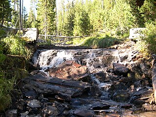
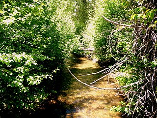
The Wood River is a short river in the southern region of the U.S. state of Oregon, and part of the Klamath Basin drainage. It flows 18 miles (29 km) through the Fremont-Winema National Forests, Bureau of Land Management land, and private property in southern Oregon. Its watershed consists of 220 square miles (570 km2) of conifer forest, rural pasture land, and marsh. The river provides habitat for many species of wildlife including an adfluvial (migratory) and resident populations of native Great Basin redband trout.

<span class="mw-page-title-main">Eastern Cascades Slopes and Foothills</span> Temperate coniferous forests ecoregion of the United States

The Eastern Cascades Slopes and Foothills ecoregion is a Level III ecoregion designated by the United States Environmental Protection Agency (EPA) in the U.S. states of Oregon, Washington, and California. In the rain shadow of the Cascade Range, the eastern side of the mountains experiences greater temperature extremes and receives less precipitation than the west side. Open forests of ponderosa pine and some lodgepole pine distinguish this region from the Cascades ecoregion, where hemlock and fir forests are more common, and from the lower, drier ecoregions to the east, where shrubs and grasslands are predominant. The vegetation is adapted to the prevailing dry, continental climate and frequent wildfire. Volcanic cones and buttes are common in much of the region.

<span class="mw-page-title-main">Klamath Mountains (ecoregion)</span> Temperate coniferous forests ecoregion in northern California and southwestern Oregon

The Klamath Mountains ecoregion of Oregon and California lies inland and north of the Coast Range ecoregion, extending from the Umpqua River in the north to the Sacramento Valley in the south. It encompasses the highly dissected ridges, foothills, and valleys of the Klamath and Siskiyou Mountains. It corresponds to the Level III ecoregion designated by the Environmental Protection Agency and to the Klamath-Siskiyou forests ecoregion designated by the World Wide Fund for Nature.

<span class="mw-page-title-main">Lake of the Woods (Oregon)</span> Lake in Oregon, United States

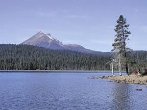
Lake of the Woods is a natural lake near the crest of the Cascade Range in the Fremont–Winema National Forest in southern Oregon in the United States. The lake covers 1,146 acres (4.64 km2). It was named by Oliver C. Applegate in 1870. Today, the Oregon Department of Fish and Wildlife manages the lake's fishery. The small unincorporated community of Lake of the Woods is located on the east shore of the lake. Lake of the Woods is one of southern Oregon's most popular outdoor recreation sites.

<span class="mw-page-title-main">Lake of the Woods Ranger Station</span> United States historic place

The Lake of the Woods Ranger Station is a United States Forest Service compound consisting of eight buildings overlooking Lake of the Woods in the Fremont-Winema National Forests of southern Oregon. All of the ranger station structures were built by the Civilian Conservation Corps between 1937 and 1939. Today, the compound serves as a Forest Service work center, and the old ranger station office is a visitor center. The ranger station is listed on the National Register of Historic Places.

<span class="mw-page-title-main">Hager Mountain</span>

Hager Mountain is a volcanic peak in Oregon in the northwest corner of the Basin and Range Province in the United States. The mountain is located south of the small unincorporated community of Silver Lake in south-central Oregon, and it is in the Fremont–Winema National Forest. On the summit, there is a fire lookout operated during the summer and fall by the United States Forest Service. There are several hiking trails that lead to the lookout station.

<span class="mw-page-title-main">Ponderosa pine forest</span>

Ponderosa pine forest is a plant association and plant community dominated by ponderosa pine and found in western North America. It is found from the British Columbia to Durango, Mexico. In the south and east, ponderosa pine forest is the climax forest, while in the more northern part of its range, it can transition to Douglas-fir or grand fir, or white fir forests. Understory species depends on location. Fire suppression has led to insect outbreaks in ponderosa pine forests.

<span class="mw-page-title-main">Barry Point Fire</span> Wildfire

The Barry Point Fire was a wildfire that burned over 92,977 acres (376.26 km2) of Oregon and California forest land during the summer of 2012. The fire began on 5 August 2012, the result of a lightning strike. The fire consumed public forest and rangeland as well as private forest and grazing land located in Lake County, Oregon and Modoc County, California. The public lands effected by the fire are administered by the United States Forest Service and the Oregon Department of Forestry. The largest part of the private land was owned by the Collins Timber Company. At the peak of the firefighting effort, there were 1,423 personnel working on the fire. It took 22 days to fully contain the fire and then an additional three weeks to mop it up.

<span class="mw-page-title-main">Crane Mountain</span>

Crane Mountain is in the Warner Mountain range and is the tallest peak in Lake County, Oregon, U.S. It is located southeast of Lakeview in south-central Oregon, near the northwest corner of the Basin and Range Province of the western United States. The mountain is in the Fremont section of the Fremont–Winema National Forest. There was a United States Forest Service fire lookout located near the summit which was removed in 1972. The Crane Mountain National Recreation Trail runs north and south along the crest of the mountain.

<span class="mw-page-title-main">Gearhart Mountain</span>

Gearhart Mountain is a 8,041-foot (2,451 m) high mountain in Lake County and Klamath County, Oregon, in the United States. It is located in the Gearhart Mountain Wilderness of the Fremont–Winema National Forest, northeast of the Sprague River valley and the town of Bly.

The Northwestern Forested Mountains is a Level I ecoregion of North America designated by the Commission for Environmental Cooperation (CEC) in its North American Environmental Atlas.

References

  1. "Climate Oregon: Temperature, Climograph, Climate table for Oregon - Climate-Data.org". en.climate-data.org. Retrieved 2017-12-05.
  2. 1 2 Orr, Elizabeth L.; Orr, William N. (2012). Oregon Geology (6th ed.). Corvallis: Oregon State University Press. pp. 61, 83. ISBN   9780870716812. OCLC   847008228.
  3. Gilbert, M. Thomas P.; Jenkins, Dennis L.; Götherstrom, Anders; Naveran, Nuria; Sanchez, Juan J.; Hofreiter, Michael; Thomsen, Philip Francis; Binladen, Jonas; Higham, Thomas F. G. (2008-05-09). "DNA from Pre-Clovis Human Coprolites in Oregon, North America". Science. 320 (5877): 786–789. doi:10.1126/science.1154116. ISSN   0036-8075. PMID   18388261. S2CID   17671309.
  4. Dillehay, Tom D. Monte Verde : a late Pleistocene settlement in Chile. Washington: Smithsonian Institution Press. pp. 122–123. ISBN   978-0874743500. OCLC   18351797.
  5. Dillehay, Tom D. (1989). Monte Verde: a late Pleistocene settlement in Chile. Washington: Smithsonian Institution Press. p. 121. ISBN   978-0874743500. OCLC   18351797.
  6. "Forest History Society". Archived from the original on 2014-01-11. Retrieved 2017-12-05.
  7. "Forest History Society - By understanding our past, we shape our future". Forest History Society. Retrieved 2017-12-05.
  8. Dyrness, C. T.; Youngberg, C. T. (1966-01-01). "Soil-Vegetation Relationships within the Ponderosa Pine Type in the Central Oregon Pumice Region". Ecology. 47 (1): 122–138. doi:10.2307/1935750. ISSN   1939-9170. JSTOR   1935750.
  9. Franklin, Jerry F.; Dyrness, C. T. (1988). Natural vegetation of Oregon and Washington (Rev. & enl. ed.). Corvallis: Oregon State University Press. p. 86. ISBN   978-0870713569. OCLC   18564613.
  10. Krueger, William C.; Anderson, William E.; Borman, Michael M. "The ecological provinces of Oregon : a treatise on the basic ecological geography of the state". ScholarsArchive@OSU: 88.
  11. 1 2 Moerman, Daniel E. (2010). Native American food plants: an ethnobotanical dictionary. Portland: Timber Press. ISBN   9781604691894. OCLC   555620134.
  12. Cronquist, Arthur; Holmgren, Noel H.; Holmgren, Patricia K.; Reveal, James L.; Barneby, Rupert C. (1972–2017). Intermountain flora; vascular plants of the Intermountain West, U.S.A. . New York: Published for the New York Botanical Garden by Hafner Pub. Co. ISBN   978-0231041201. OCLC   320442.
  13. Taylor, Ronald J. (1992). Sagebrush country : a wildflower sanctuary ([Rev. ed.] ed.). Missoula, MT: Mountain Press Pub. Co. ISBN   9780878422807. OCLC   25708726.
  14. "Status of the Larch Mountain Salamander (Plethodon larselli) in Washington - WDFW Publications | Washington Department of Fish & Wildlife". wdfw.wa.gov. Retrieved 2017-12-05.
  15. Franklin, Jerry F.; Dyrness, C. T. (1988). Natural vegetation of Oregon and Washington ([Rev. & enl. ed.] ed.). Corvallis: Oregon State University Press. p. 49. ISBN   9780870713569. OCLC   18564613.
  16. Ager, A. A.; Finney, M. A.; McMahan, A.; Cathcart, J. (2010-12-07). "Measuring the effect of fuel treatments on forest carbon using landscape risk analysis". Nat. Hazards Earth Syst. Sci. 10 (12): 2515–2526. doi: 10.5194/nhess-10-2515-2010 . ISSN   1684-9981.
  17. Ager, Alan A.; Vaillant, Nicole M.; Finney, Mark A.; Preisler, Haiganoush K. (2012). "Analyzing wildfire exposure and source–sink relationships on a fire prone forest landscape". Forest Ecology and Management. 267: 271–283. doi:10.1016/j.foreco.2011.11.021.
  18. Hitchcock, C. Leo; Cronquist, Arthur; Janish, Jeanne R. (1973). Flora of the Pacific Northwest; an illustrated manual . Seattle: University of Washington Press. ISBN   978-0295952734. OCLC   524274.
  19. Richardson, D. M. (1998). Ecology and biogeography of Pinus. Cambridge: Cambridge University Press. p. 283. ISBN   9780521551762. OCLC   36621846.
  20. Bal, Amandeep; Chanway, Christopher P. (2012-08-22). "Evidence of nitrogen fixation in lodgepole pine inoculated with diazotrophic Paenibacillus polymyxa". Botany. 90 (9): 891–896. doi:10.1139/b2012-044. ISSN   1916-2790.
  21. Bitz, Julie. "Lodgepole Pine Dwarf Mistletoe - FIDL". www.na.fs.fed.us. Retrieved 2017-12-05.
  22. Peinado, M.; Aguirre, J.l.; Delgadillo, J. (1997-08-01). "Phytosociological, bioclimatic and biogeographical classification of woody climax communities of western North America". Journal of Vegetation Science. 8 (4): 505–528. doi:10.2307/3237202. ISSN   1654-1103. JSTOR   3237202.
  23. Conrad, Clarence Frederick (1953). Geology of the Ana River section, Summer Lake, Oregon. Oregon State College.
  24. Ansley, R. James; Rasmussen, G. Allen (2005). "Managing Native Invasive Juniper Species Using Fire". Weed Technology. 19 (3): 517–522. doi:10.1614/WT-04-098R1.1. JSTOR   3989470. S2CID   85754004.
  25. Young, J. A.; Clements, C. D. (2000-08-01). "Cheatgrass control and seeding". Rangelands Archives. 22 (4): 3–7. doi: 10.2458/azu_rangelands_v22i4_young . ISSN   0190-0528.