Grants Pass is a city in and the county seat of Josephine County, Oregon, United States. The city is located on Interstate 5, northwest of Medford, along the Rogue River. The population is 39,194 according to the 2020 census, making it the 15th most populous city in Oregon.

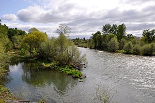
The Rogue River in southwestern Oregon in the United States flows about 215 miles (346 km) in a generally westward direction from the Cascade Range to the Pacific Ocean. Known for its salmon runs, whitewater rafting, and rugged scenery, it was one of the original eight rivers named in the Wild and Scenic Rivers Act of 1968. Beginning near Crater Lake, which occupies the caldera left by the explosive volcanic eruption and collapse of Mount Mazama, the river flows through the geologically young High Cascades and the older Western Cascades, another volcanic province. Further west, the river passes through multiple exotic terranes of the more ancient Klamath Mountains. In the Kalmiopsis Wilderness section of the Rogue basin are some of the world's best examples of rocks that form the Earth's mantle. Near the mouth of the river, the only dinosaur fragments ever discovered in Oregon were found in the Otter Point Formation, along the coast of Curry County.

The Oregon Coast Trail (OCT) is a long-distance hiking route along the Pacific coast of the U.S. state of Oregon in the United States. It follows the coast of Oregon from the mouth of the Columbia River to the California border south of Brookings.

Goose Lake is a large alkaline lake in the Goose Lake Valley on the Oregon–California border in the United States. Like many other lakes in the Great Basin, it is a pluvial lake that formed from precipitation and melting glaciers during the Pleistocene epoch. The north portion of the lake is in Lake County, Oregon, and the south portion is in Modoc County, California. The mountains at the north end of the lake are part of the Fremont National Forest, and the south end of the lake is adjacent to Modoc National Forest lands. Most of the valley property around the lake is privately owned agricultural land, though Goose Lake State Recreation Area is on the Oregon side of the lake.

Oswald West State Park is part of the state park system of the U.S. state of Oregon. It is located about 10 miles (16 km) south of the city of Cannon Beach, adjacent to Arch Cape, on the Pacific Ocean. The park covers 2,448 acres (9.91 km2), with many miles of hiking trails both inside the park grounds and linking to other parks and landmarks beyond.
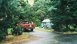
TouVelle State Recreation Site is a state park, administered by Oregon Parks and Recreation Department, and located in Jackson County, Oregon, United States, 9 miles (14 km) north of Medford, where Table Rock Road crosses the Rogue River. This 51-acre (210,000 m2) park is used for fishing, birding, hiking, picnicking and swimming. There is also a boat ramp, which lies at the lower end of an easily navigated stretch of the Rogue. A daily user-fee or annual permit is required.

Applegate Lake is a 988-acre (400 ha) reservoir located in the Rogue River–Siskiyou National Forest about 27 miles (43 km) southwest of Medford in the U.S. state of Oregon. It is 16 miles (26 km) south of Oregon Route 238 along Applegate River Road and slightly north of the Oregon–California border. The lake is an impoundment of the Applegate River about 46 miles (74 km) from its confluence with the Rogue River.

Tumalo State Park is a well-developed state park in Deschutes County, Oregon, United States. Established in 1954, the park is located northwest of the city of Bend and along the Deschutes River at a site home to many bird species. The park is popular for picnics, swimming, fishing, hiking, and camping, and is open year-round.
Sarah Helmick State Recreation Site, also known as Helmick Park, is a state park located south of Monmouth, in Polk County, Oregon, United States. It is located on the floodplain of the Luckiamute River and is forested by Bigleaf Maple, Douglas-fir, and Black Cottonwood trees, among other varieties. The park is named for Sarah Helmick, a pioneer to Oregon in 1845 who donated the original land. Sarah Helmick State Recreation Site is the first state park established in Oregon. It was listed on the National Register of Historic Places in 2022.

The Deschutes River State Recreation Area is a park at the confluence of the Deschutes and Columbia rivers in the U.S. state of Oregon. It is a few miles east of The Dalles. The 35.1-acre (14.2 ha) park offers opportunities for camping, fishing, hiking, mountain biking, and equestrian trail riding.

D River State Recreation Site is a state park in the U.S. state of Oregon, administered by the Oregon Parks and Recreation Department. It is a sandy beach of the Pacific Ocean within central Lincoln City along the length of the 120-foot (37 m) long D River, one of the world's shortest rivers.

Devil's Lake State Recreation Area is a state park in the U.S. state of Oregon, administered by the Oregon Parks and Recreation Department.

Sunset Bay State Park is a state park in the U.S. state of Oregon. Administered by the Oregon Parks and Recreation Department, it is about 0.4 miles (0.6 km) south of Cape Arago Lighthouse and 2.5 miles (4.0 km) outside the town of Charleston on Coos Bay. The park offers a crescent shaped beach, tide pools, hiking trails and a year-round campground.

The Rogue River in the U.S. state of Oregon begins at Boundary Springs on the border between Klamath and Douglas counties near the northern edge of Crater Lake National Park. The Rogue River flows generally west for 215 miles (346 km) from the Cascade Range through the Rogue River – Siskiyou National Forest and the Klamath Mountains to the Pacific Ocean at Gold Beach. Communities along its course include Union Creek, Prospect, Trail, Shady Cove, Gold Hill, and Rogue River, all in Jackson County; Grants Pass, and Galice in Josephine County, and Agness, Wedderburn and Gold Beach in Curry County. Significant tributaries include the South Fork Rogue River, Elk Creek, Bear Creek, the Applegate River, and the Illinois River. Arising at 5,320 feet (1,622 m) above sea level, the river loses more than 1 mile (1.6 km) in elevation by the time it reaches the Pacific.
The South Fork Rogue River is a 25-mile (40 km) tributary of the Rogue River in the U.S. state of Oregon. Rising in the Sky Lakes Wilderness in the Cascade Range, it flows generally northeast through the Rogue River – Siskiyou National Forest to meet the Rogue River downstream of Prospect and slightly upstream of Lost Creek Lake.
Illahe is an unincorporated community and the site of a former post office in Curry County, Oregon, United States. Located along the Rogue River about 8 miles (13 km) upriver from Agness, the area was home to Takelma Indians, then to white and Karok settlers, before becoming part of a designated wilderness. In the 21st century, it is a stopping place for hikers, boaters, and other visitors. The area has a riverside lodge and a nearby campground, both named Illahe.

Union Creek is a 15-mile (24 km) long tributary of the Rogue River in the U.S. state of Oregon. Beginning west of Union Peak in the Cascade Range, it flows through the Rogue River – Siskiyou National Forest to meet the Rogue at Union Creek and the Union Creek Historic District.

The Little North Santiam River is a 27-mile (43 km) tributary of the North Santiam River in western Oregon in the United States. It drains 113 square miles (290 km2) of the Cascade Range on the eastern side of the Willamette Valley east of Salem.

Sisters State Park is a state park located at the southeast side of the town of Sisters in Deschutes County, Oregon, United States. The park property is bisected by U.S. Route 20 and Oregon Route 126, creating three separate parcels. The park covers 28 acres (11 ha) of undeveloped forest land along Whychus Creek. It is adjacent to two developed city parks that were once part of the state park. Sisters State Park is administered by the Oregon Parks and Recreation Department.