Waldport is a city in Lincoln County, Oregon, United States. The population was 2,033 at the 2010 census. The city is located on the Alsea River and Alsea Bay, 15 miles (24 km) south of Newport and 8 miles (13 km) north of Yachats.

Yachats is a small coastal city in the southernmost area of Lincoln County, Oregon, United States. According to Oregon Geographic Names, the name comes from the Siletz language and means "dark water at the foot of the mountain". There is a range of differing etymologies, however. William Bright says the name comes from the Alsea placename yáx̣ayky. At the 2010 census, the city's population was 690. In 2007, Budget Travel magazine named Yachats one of the "Ten Coolest Small Towns of the U.S.A.", and Yachats was chosen among the top 10 U.S. up-and-coming vacation destinations by Virtualtourist. In 2015, Arthur Frommer, founder of Frommer's Travel Guides, listed Yachats number eight among his ten favorite vacation destinations in the world.

The Alsea River flows 48.5 miles (78.1 km) from Alsea, an unincorporated community in the coastal mountains of the U.S. state of Oregon, to the Pacific Ocean near the city of Waldport. It begins at the confluence of the North Fork Alsea River and the South Fork Alsea River and ends in Alsea Bay, a wide estuary at Waldport. The river flows generally west-northwest in a winding course through the mountains of southern Benton and Lincoln counties, passing near the unincorporated community of Tidewater and through the Siuslaw National Forest. Its drainage basin extends into Lane County, along the headwaters of the South Fork Alsea River.
The Oregon Department of Transportation (ODOT) is a department of the state government of the U.S. state of Oregon responsible for systems of transportation. It was first established in 1969. It had been preceded by the Oregon State Highway Department which, along with the Oregon State Highway Commission, was created by an act of the Oregon Legislative Assembly in 1913. It works closely with the five-member Oregon Transportation Commission in managing the state's transportation systems.

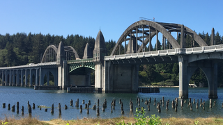
The Alsea Bay Bridge is a concrete arch bridge that spans the Alsea Bay on U.S. Route 101 (US 101) near Waldport, Oregon.
The Siuslaw River Bridge is a bascule bridge that spans the Siuslaw River on U.S. Route 101 in Florence, Oregon. It was designed by Conde McCullough, built by the Mercer-Fraser Company of Eureka, California, and funded by the Federal Emergency Administration of Public Works. It opened in 1936.

Oregon Route 34 is a state highway in the U.S. state of Oregon that runs between the city of Waldport on the Oregon Coast and the city of Lebanon in the western part of the state. OR 34 traverses the Alsea Highway No. 27 from Waldport to Flynn, part of the Corvallis–Newport Highway No. 33 from Flynn to east of Corvallis, and the Corvallis–Lebanon Highway No. 210 from east of Corvallis to Lebanon, of the Oregon state highway system. In Corvallis, OR 34 includes a brief concurrency with U.S. Route 20 and OR 99W over the Pacific Highway West No. 1W.
The Alsea are a Native American tribe of Oregon. Alsea may also refer to:

Alsea is an unincorporated community in Benton County, in the U.S. state of Oregon. It is on Oregon Route 34 and the Alsea River. For statistical purposes, the United States Census Bureau has defined Alsea as a census-designated place (CDP). The census definition of the area may not precisely correspond to local understanding of the area with the same name. As of the 2010 Census, the population was 164.

Tidewater is an unincorporated community in Lincoln County, Oregon, United States located on the Alsea River east of Waldport on Oregon Route 34.
Fisher is an unincorporated community in rural Lincoln County, Oregon, United States. Fisher lies along Five Rivers Road, 9.2 miles (14.8 km) south of its intersection with Oregon Route 34. It is slightly north of the Lincoln–Lane county line in the Siuslaw National Forest. A stream called Five Rivers flows west through Fisher, about 12 miles (19 km) by water from the stream's mouth on the Alsea River. Route 34 runs along the Alsea River between Alsea and Waldport.

W. B. Nelson State Recreation Site is a state park in Lincoln County, western Oregon.
The Lincoln County School District is a public school district in the U.S. state of Oregon. The district serves the communities of Yachats, Waldport, Eddyville, Newport, Siletz, Lincoln City and Toledo. The district spans roughly 55 miles of the central Oregon Coast from Cascade Head south to Cape Perpetua, and encompasses about 1,000 square miles.

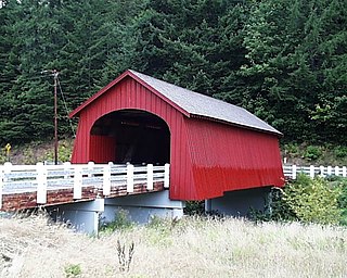
Hayden Bridge, a Howe truss structure, spans the Alsea River about 2 miles (3 km) west of Alsea, Oregon, United States. Constructed in 1918, the 91-foot (28 m) span is one of only seven remaining covered bridges in Oregon that were built before 1920. Similar spans such as the Mill Creek Bridge crossed the Alsea or one of its tributaries in the same vicinity, but only the Hayden Bridge has survived. It was added to the National Register of Historic Places in 1979.
The Red River is a stream approximately 1 mile (2 km) long in Lincoln County in the northwestern U.S. state of Oregon. It rises south of downtown Waldport and flows through the city to meet the Alsea River near the larger river's mouth on the Pacific Ocean.
Five Rivers is a tributary of the Alsea River in the U.S. state of Oregon, in Lane, Lincoln, Benton counties. The name Five Rivers refers to the relative importance to the stream of five of its tributaries: Alder, Cougar, Buck, Crab, and Cherry creeks.
David Anthony Durham is an American wanted fugitive who disappeared under mysterious circumstances after shooting and critically injuring a police officer during a traffic stop in Lincoln City, Oregon. After shooting the officer, Durham's vehicle was rendered inoperable via a spike strip 40 miles (64 km) south in Waldport, where he fled on foot and began shooting at a crab fisherman in Alsea Bay before disappearing. Durham's whereabouts remain unknown.
Alsea Bay is a body of water near Waldport, Oregon at the mouth of the Alsea River. It is a site for beach angling. It is spanned by the Alsea Bay Bridge and is in Lincoln County, Oregon.
Bayshore is an unincorporated community and census-designated place (CDP) in Lincoln County, Oregon, United States. It was first listed as a CDP prior to the 2020 census.


