
Yachats is a small coastal city in the southernmost area of Lincoln County, Oregon, United States. According to Oregon Geographic Names, the name comes from the Siletz language and means "dark water at the foot of the mountain". There is a range of differing etymologies, however. William Bright says the name comes from the Alsea placename yáx̣ayky. At the 2010 census, the city's population was 690. In 2007, Budget Travel magazine named Yachats one of the "Ten Coolest Small Towns of the U.S.A.", and Yachats was chosen among the top 10 U.S. up-and-coming vacation destinations by Virtualtourist. In 2015, Arthur Frommer, founder of Frommer's Travel Guides, listed Yachats number eight among his ten favorite vacation destinations in the world.

Oceanside is a census-designated place (CDP) and unincorporated community in Tillamook County, Oregon, United States. The population was 361 at the 2010 census. Oregon Route 131's northern terminus is in the community, which is just north of Netarts. Symons State Park is in Oceanside, while Three Arch Rocks National Wildlife Refuge lies just offshore.

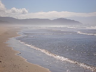
The Oregon Coast is a coastal region of the U.S. state of Oregon. It is bordered by the Pacific Ocean to its west and the Oregon Coast Range to the east, and stretches approximately 362 miles (583 km) from the California state border in the south to the Columbia River in the north. The region is not a specific geological, environmental, or political entity, and includes the Columbia River Estuary.

Cape Blanco is a prominent headland on the Pacific Ocean coast of southwestern Oregon in the United States, forming the westernmost point in the state. Cape Blanco extends further west than any point of land in the contiguous United States except portions of the Olympic Peninsula in Washington, including Cape Alava, the true westernmost point. The cape is part of Cape Blanco State Park and is the location of the Cape Blanco Light, first lit in 1870.

The Oregon Coast Trail (OCT) is a long-distance hiking route along the Pacific coast of the U.S. state of Oregon in the United States. It follows the coast of Oregon from the mouth of the Columbia River to the California border south of Brookings.

The Lewis and Clark National Historical Park, located in the vicinity of the mouth of the Columbia River, commemorates the Lewis and Clark Expedition. Administration of the park, which includes both federal and state lands, is a cooperative effort of the National Park Service and the states of Oregon and Washington. The National Historical Park was dedicated on November 12, 2004.

Haystack Rock is a 235 ft-tall (72 m) sea stack in Cannon Beach, Oregon. It is the third-tallest such intertidal structure in the world. A popular tourist destination on the Oregon Coast, the monolithic rock is adjacent to the beach and accessible by foot at low tide. The Haystack Rock tide pools are home to many intertidal animals, including starfish, sea anemone, crabs, chitons, limpets, and sea slugs. The rock is also a nesting site for many sea birds, including terns and puffins.

Assateague Island National Seashore is a unit of the National Park Service system of the U.S. Department of the Interior. Located on the East Coast along the Atlantic Ocean in Maryland and Virginia, Assateague Island is the largest natural barrier island ecosystem in the Middle Atlantic states region that remains predominantly unaffected by human development. Located within a three-hour drive to the east and south of Richmond, Washington, Baltimore, Wilmington, Philadelphia major metropolitan areas plus north of the several clustered smaller cities around Hampton Roads harbor of Virginia with Newport News, Hampton, Norfolk, Portsmouth, Chesapeake and Virginia Beach. The National Seashore offers a setting in which to experience a dynamic barrier island and to pursue a multitude of recreational opportunities. The stated mission of the park is to preserve and protect “unique coastal resources and the natural ecosystem conditions and processes upon which they depend, provide high-quality resource-based recreational opportunities compatible with resource protection and educate the public as to the values and significance of the area”.

The Long Beach Peninsula is an arm of land on the southern coast of the state of Washington in the United States. Entirely within Pacific County, it is bounded on the west by the Pacific Ocean, the south by the Columbia River, and the east by Willapa Bay. Leadbetter Point State Park and Willapa National Wildlife Refuge are at the northern end of the peninsula and Cape Disappointment is at the southern end, with Pacific Pines State Park located in between.

Oswald West State Park is part of the state park system of the U.S. state of Oregon. It is located about 10 miles (16 km) south of the city of Cannon Beach, adjacent to Arch Cape, on the Pacific Ocean. The park covers 2,448 acres (9.91 km2), with many miles of hiking trails both inside the park grounds and linking to other parks and landmarks beyond.
The Oregon Coast National Wildlife Refuge Complex consists of six National Wildlife Refuges along the Oregon Coast. It provides wilderness protection to thousands of small islands, rocks, reefs, headlands, marshes, and bays totaling 371 acres spanning 320 miles (515 km) of Oregon's coastline. The areas are all managed by the United States Fish and Wildlife Service.
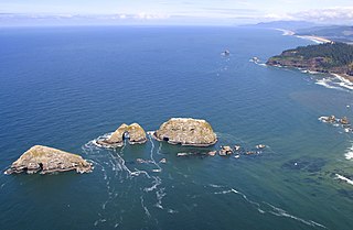
Three Arch Rocks National Wildlife Refuge is a U.S. National Wildlife Refuge off the northern Oregon Coast. It is located on the central coast of Tillamook County, in the northwestern part of Oregon. It is one of six National Wildlife Refuges within the Oregon Coast National Wildlife Refuge Complex and was the first National Wildlife Refuge west of the Mississippi River. In 1970 the Refuge was designated as wilderness. It is one of the smallest wilderness areas in the United States.
Cape Meares National Wildlife Refuge is a National Wildlife Refuge of the Oregon Coast. It is one of six National Wildlife Refuges in the Oregon Coast National Wildlife Refuge Complex. Located on Cape Meares, the refuge was established in 1938 to protect a remnant of coastal old-growth forest and the surrounding habitat used by breeding seabirds. The area provides a home for a threatened bird species, the marbled murrelets. Peregrine falcons, once at the brink of extinction, have nested here since 1987. The refuge, with the exception of the Oregon Coast Trail, was designated a Research Natural Area in 1987.

Siletz Bay National Wildlife Refuge is a U.S. National Wildlife Refuge on Oregon's coast. It is one of six National Wildlife Refuges (NWRs) comprising the Oregon Coast National Wildlife Refuge Complex. The refuge consists of several discontinuous tracts north and south of the Siletz River where it enters Siletz Bay south of Lincoln City. Previously closed to public use, excluding viewing from outside the refuge boundaries and during special events, the refuge now has a boat launch offering access to non-motorized boats. Alder Island Nature Trail caters to visitors on foot, opened in 2017, and is 0.85 miles (1.37 km) round trip.

Samuel H. Boardman State Scenic Corridor is a linear state park in southwestern Oregon, in the United States. It is 12 miles (19 km) long and thickly forested along steep and rugged coastline with a few small sand beaches. It is named in honor of Samuel H. Boardman, the first Oregon Parks superintendent.

Hug Point State Recreation Site is a state park on the northern Oregon Coast in the U.S. state of Oregon. Administered by the Oregon Parks and Recreation Department, the park is open to the public and is fee-free. Amenities at the park, which is 5 miles (8.0 km) south of Cannon Beach along U.S. Route 101, include picnicking, fishing, and a Pacific Ocean beach.

Devils Punch Bowl State Natural Area is a state day use park on the central Oregon Coast in the United States. It is centered on a large bowl naturally carved in a rock headland which is partially open to the Pacific Ocean. Waves enter the bowl and often violently churn, swirl, and foam. Outside the bowl, ocean conditions are attractive to surfers near a large offshore rock pinnacle named Gull Rock, located about 1⁄2 mile (800 m) west-northwest of Devils Punch Bowl, which funnels and concentrates waves easily seen from the park. There are at least seventeen large rocks, part of Oregon Islands National Wildlife Refuge, which provide interesting wave viewing, and attract and provide a home for wildlife.

Driftwood Beach State Recreation Site is a state park administered by the Oregon Parks and Recreation Department in the U.S. state of Oregon. Located 3 miles (5 km) north of Waldport along the Pacific Ocean, the park offers beach access, picnicking, and fishing in a setting of shore pines and sand. It is fee-free and open year-round.

Sunset Bay State Park is a state park in the U.S. state of Oregon. Administered by the Oregon Parks and Recreation Department, it is about 0.4 miles (0.6 km) south of Cape Arago Lighthouse and 2.5 miles (4.0 km) outside the town of Charleston on Coos Bay. The park offers a crescent shaped beach, tide pools, hiking trails and a year-round campground.

Floras Lake is a natural 236-acre (96 ha) body of water on the southern Oregon Coast of the United States. Fed by four small tributaries from a basin of about 10 square miles (26 km2) in Curry County, it lies about 10 miles (16 km) north of Port Orford and 2 miles (3 km) west of U.S. Route 101. It was probably named for Fred Flora, a 19th-century settler and miner who lived nearby.


