Sleeping Bear Dunes National Lakeshore is a United States National Lakeshore located along the northwest coast of the Lower Peninsula of Michigan in Leelanau and Benzie counties near Empire, Michigan. The park covers a 35-mile-long (56 km) stretch of Lake Michigan's eastern coastline, as well as North and South Manitou islands. This Northern Michigan park was established primarily because of its outstanding natural features, including forests, beaches, dune formations, and ancient glacial phenomena. The lakeshore also contains many cultural features including the 1871 South Manitou Island Lighthouse, three former stations of the Coast Guard and an extensive rural historic farm district. In 2011, the area won the title of "The Most Beautiful Place in America" from Good Morning America. In 2014, a section of the park was named the Sleeping Bear Dunes Wilderness by the United States Congress.

The Oregon Coast Trail (OCT) is a long-distance hiking route along the Pacific coast of the U.S. state of Oregon in the United States. It follows the coast of Oregon from the mouth of the Columbia River to the California border south of Brookings.

Goose Lake is a large alkaline lake in the Goose Lake Valley on the Oregon–California border in the United States. Like many other lakes in the Great Basin, it is a pluvial lake that formed from precipitation and melting glaciers during the Pleistocene epoch. The north portion of the lake is in Lake County, Oregon, and the south portion is in Modoc County, California. The mountains at the north end of the lake are part of the Fremont National Forest, and the south end of the lake is adjacent to Modoc National Forest lands. Most of the valley property around the lake is privately owned agricultural land, though Goose Lake State Recreation Area is on the Oregon side of the lake.

Foster Reservoir is a reservoir created by Foster Dam on the South Santiam River in the city of Foster, Oregon, United States. The reservoir is approximately 5.6 km (3.5 mi) long and covers approximately 494 ha when full. Primary use of the reservoir is recreation in the summer and flood control in the winter and spring.

Oswald West State Park is part of the state park system of the U.S. state of Oregon. It is located about 10 miles (16 km) south of the city of Cannon Beach, adjacent to Arch Cape, on the Pacific Ocean. The park covers 2,448 acres (9.91 km2), with many miles of hiking trails both inside the park grounds and linking to other parks and landmarks beyond.

Lake Billy Chinook is a reservoir in Jefferson County in the U.S. state of Oregon. Created by the Round Butte Dam in 1964, Lake Billy Chinook lies in a canyon at the confluence of the Crooked, Deschutes, and Metolius rivers near Culver and Madras. It was named for Billy Chinook, a Native American of the Wasco tribe who traveled alongside American explorers John C. Frémont and Kit Carson in their expeditions of 1843 and 1844.

Twin Lakes State Park is a 175-acre (71 ha) state park on the western shore of Lake Roland in Houghton County, Michigan. It is located in the Elm River Township, Michigan along M-26.

Beaver Lake State Park is a public recreation area located in Logan County, North Dakota, about equidistant from Napoleon and Wishek. The state park occupies 273 acres (110 ha) of land on the western shore of 968-acre (392 ha) Beaver Lake and offers hiking, boating, swimming, fishing, cabins, and campground.

Goose Lake State Recreation Area is located on Stateline Road, between New Pine Creek, Oregon and Goose Lake in Lake County, Oregon, on the east side of Goose Lake on the Oregon–California border.

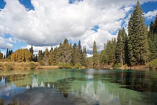
Jackson F. Kimball State Recreation Site is a state park in southern Oregon. The park is operated and maintained by the Oregon Parks and Recreation Department, and is located approximately 20 miles (32 km) southeast of Crater Lake National Park and 3 miles (4.8 km) north of Fort Klamath. The park was established in 1955, and covers 19 acres (7.7 ha) including the headwaters of the Wood River.

The Deschutes River State Recreation Area is a park at the confluence of the Deschutes and Columbia rivers in the U.S. state of Oregon. It is a few miles east of The Dalles. The 35.1-acre (14.2 ha) park offers opportunities for camping, fishing, hiking, mountain biking, and equestrian trail riding.

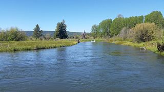
The Wood River is a short river in the southern region of the U.S. state of Oregon, and part of the Klamath Basin drainage. It flows 18 miles (29 km) through the Fremont-Winema National Forests, Bureau of Land Management land, and private property in southern Oregon. Its watershed consists of 220 square miles (570 km2) of conifer forest, rural pasture land, and marsh. The river provides habitat for many species of wildlife including an adfluvial (migratory) and resident populations of native Great Basin redband trout.

Wallowa Lake State Park is a state park located in northeast Oregon in the United States. It is at the southern shore of Wallowa Lake, near the city of Joseph in Wallowa County. The town of Wallowa Lake is situated next to the park.

Cline Falls State Scenic Viewpoint is a state park near Redmond, Oregon, United States. It is located on the Deschutes River. The park covers 9 acres (36,000 m2). It is administered by the Oregon Parks and Recreation Department.

D River State Recreation Site is a state park in the U.S. state of Oregon, administered by the Oregon Parks and Recreation Department. It is a sandy beach of the Pacific Ocean within central Lincoln City along the length of the 120-foot (37 m) long D River, one of the world's shortest rivers.
Umbagog Lake State Park is a 1,360-acre (550 ha) park in Errol, New Hampshire, on the southern shore of Umbagog Lake along Route 26. It is adjacent to the Umbagog National Wildlife Refuge.

Chief White Crane Recreation Area is a state recreation area in southeastern South Dakota, United States. It is located about 5 miles (8.0 km) west of Yankton and located on the shores of the Missouri River and Lake Yankton. The recreation area is located about 1.5 miles (2.4 km) downstream of Gavins Point Dam and Lewis and Clark Lake.
Sandy Shore Recreation Area is a South Dakota State Recreation Area in east-central South Dakota, United States, near Watertown. The recreation area is located on the shore of Lake Kampeska, a 5,250-acre inland glacial lake. Within the recreation area is a beach, boat ramp, 17-site campground and canoe/kayak rentals. At 19 acres in size, it is South Dakota's smallest state park.
Volga River State Recreation Area is a 5,700-acre (2,300 ha) state recreation area in Fayette County, Iowa, United States, near the city of Fayette. The park is located in a forested and hilly region along the Volga River and also includes the 138-acre (56 ha) Frog Hollow Lake.
Marble Beach State Recreation Area is a 64-acre (26 ha) state recreation area in Dickinson County, Iowa, United States, near the city of Orleans. The recreation area is located on the western shore of Big Spirit Lake and is one of several state parks and recreation areas in Iowa Great Lakes region. It is home to the largest state-owned campground in the region and one of the state's most popular, which includes electric and non-electric campsites and modern facilities. The park also includes a boat ramp onto the lake and fishing areas.


